Diksmuide
Diksmuide
Diksmude | |
|---|---|
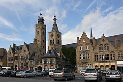 Town Hall and St Nicholas Church | |
 Flag  Coat of arms | |
 Diksmuide Location in Belgium
show Location of Diksmuide in West Flanders | |
| Coordinates: 51°02′00″N 2°52′00″E / 51.0333°N 2.8667°E | |
| Country | Belgium |
| Community | Flemish Community |
| Region | Flemish Region |
| Province | West Flanders |
| Arrondissement | Diksmuide |
| Government | |
| • Mayor | Lies Laridon (CD&V) |
| • Governing party/ies | CD&V, sp.a-Open |
| Area | |
| • Total | 149.40 km2 (57.68 sq mi) |
| Population (2018-01-01)[1] | |
| • Total | 16,739 |
| • Density | 110/km2 (290/sq mi) |
| Postal codes | 8600 |
| Area codes | 051 |
| Website | www |


Diksmuide (Dutch pronunciation: [ˌdɪksˈmœy̯də]; French: Dixmude, West Flemish: Diksmude) is a Belgian city and municipality in the Flemish province of West Flanders. The municipality comprises the city of Diksmuide proper and the former communes of Beerst, Esen, Kaaskerke, Keiem, Lampernisse, Leke, Nieuwkapelle, Oostkerke, Oudekapelle, Pervijze, Sint-Jacobs-Kapelle, Stuivekenskerke, Vladslo and Woumen.
Most of the area west of the city is a polder riddled with drainage trenches. The major economic activity of the region is dairy farming, producing the famous butter of Diksmuide.
History[]
Medieval origins[]
The 9th-century Frankish settlement of Dicasmutha was situated at the mouth of a stream near the River Yser (Dutch: IJzer). The name is a compound of the Dutch words dijk (dike) and muide (river mouth). By the 10th century, a chapel and marketplace were already established. The city's charter was granted two centuries later and defensive walls built in 1270. The economy was already then based mainly on agriculture, with dairy products and linen driving the economy.
From the 15th century to the French Revolution, Diksmuide was affected by the wars between the Netherlands, France, Spain, and Austria, with a corresponding decline in activity; it was captured by Allied forces in the Capitulation of Diksmuide in 1695. The 19th century was more peaceful and prosperous.
World War I[]
At the outset of World War I, German troops crossed the Belgian border near Arlon, then proceeded hurriedly towards the North Sea to secure the French ports of Calais and Dunkirk. The Battle of the Yser started in October 1914. Thanks to the water the Belgians were able to stop the Germans; at the end of October, they opened the floodgates holding back the River Yser and flooded the area. As a result, the river became a front line throughout the First World War. The city was first attacked on 16 October 1914 and defended by Belgian and French troops, which marked the beginning of the battle. Colonel Alphonse Jacques led the troops that prevented Diksmuide from being taken by the German Army. Despite the heavy Belgian losses, the press, politicians, literary figures and the military itself created propaganda which formed public opinion into making the action appear strategic and heroic.[2]
By the time the fighting ended, the town had been reduced to rubble. It was, however, completely rebuilt in the 1920s.
Sights[]


- The belfry contains a 30-bell carillon and is a UNESCO World Heritage Site, on the list Belfries of Belgium and France.[3]
- The City Hall and neighbouring Saint Nicolas Church were completely rebuilt after World War I in the Gothic style of the 14th and 15th centuries.
- The "Trench of Death" (Dutch: Dodengang), about 1.5 km (0.93 mi) from the centre of the city, preserves the trench setting where Belgian soldiers fought under the most perilous conditions until the final offensive of 28 September 1918.
- A peace monument, the Yser Tower, was built after the First World War in the 1920s. It was demolished in 1946 because during the Second World War it had been the scene of Nazi ceremonies and collaboration. A new tower was built in the 1950s. The tower houses a World War I museum owned by the United Nations, where it is possible among other things to experience the odour of mustard gas. The Yser Tower is also the scene of the yearly IJzerbedevaart (Dutch for 'Pilgrimage of the Yser'), a celebration of peace and of Flemish political autonomy. During World War II, it was used for Nazi-inspired meetings. After the war it still had problems with neo-Nazis from all over Europe. They were a minority, but the press emphasised this minority participation. However, after many years the organisers succeeded in banning neo-Nazis. The more radical Flemish faction now organizes the IJzerwake (Dutch for 'Yser Vigil').
- Several military cemeteries are located around Diksmuide, including the Vladslo German war cemetery, which is now the resting place for more than 25,000 German soldiers and has the famous sculpture of the 'Mourning parents' by Käthe Kollwitz.
- Diksmuide used to have its own weekly magazine called Weekblad van Dixmude.
Notable inhabitants[]

- nl:Pierre Morel-Danheel(1773-1856), politician
- Maria Doolaeghe (1803–1884), writer
- Wim Vansevenant, record three-time Tour de France Lanterne rouge winner
Twin cities[]
 Ellesmere, United Kingdom
 Ploemeur, France
 Rottach-Egern, Germany
- Finnentrop, Germany
References[]
- ^ "Wettelijke Bevolking per gemeente op 1 januari 2018". Statbel. Retrieved 9 March 2019.
- ^ Fichou, Jean-Christophe (2010). "Les Pompons Rouges à Dixmude: L'Envers d'une Légende" [The Red Pompons in Diksmuide: The Other Side of a Legend]. Guerres mondiales et conflits contemporains (in French). Presses Universitaires de France. 240 (4): 5–21. doi:10.3917/gmcc.240.0005. ISSN 0984-2292. OCLC 909782173.
- ^ "World Heritage List | Belfries of Belgium and France". UNESCO. Retrieved 16 March 2021.
- ^ "Weekblad van Dixmude". lib.ugent.be. Retrieved 28 September 2020.
External links[]
| Wikimedia Commons has media related to Diksmuide. |
- Official website
 (in Dutch)
| show Places adjacent to Diksmuide |
|---|

| show Authority control |
|---|
- Diksmuide
- Sub-municipalities of Diksmuide
- Municipalities of West Flanders
- World Heritage Sites in Belgium