Torhout
Torhout | |
|---|---|
 Town Hall | |
 Flag  Coat of arms | |
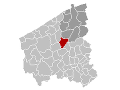
 Torhout Location in Belgium
show Location of Torhout in West Flanders | |
| Coordinates: 51°03′N 03°06′E / 51.050°N 3.100°ECoordinates: 51°03′N 03°06′E / 51.050°N 3.100°E | |
| Country | Belgium |
| Community | Flemish Community |
| Region | Flemish Region |
| Province | West Flanders |
| Arrondissement | Bruges |
| Government | |
| • Mayor | (CD&V) |
| • Governing party/ies | CD&V |
| Area | |
| • Total | 45.23 km2 (17.46 sq mi) |
| Population (2018-01-01)[1] | |
| • Total | 20,530 |
| • Density | 450/km2 (1,200/sq mi) |
| Postal codes | 8820 |
| Area codes | 050 |
| Website | www.torhout.be |

Torhout (Dutch pronunciation: [ˈtɔrɦʌu̯t]) (West Flemish: Toeroet) is a municipality located in the Belgian province of West Flanders. The municipality comprises the city of Torhout proper, the villages of Wijnendale and , and the hamlet of . On January 1, 2012, Torhout had a total population of 20,149. The total area is 45.23 km² which gives a population density of 445 inhabitants per km².
People associated with Torhout[]
- Rimbert, saint
- Josse van Huerter, first settler, and captain-major of the island of Faial in the Portuguese Azores.
- Karel Van Wijnendaele (Founder of Tour of Flanders (Tour of Flanders))
- Benny Vansteelant (Multiple World Champion Duathlon) and
- Luk Descheemaeker, winner at the 2nd Holocaust cartoon contest in Tehran, 2016.
- Hilde Crevits, Vice Minister-President of the Flemish Government and Flemish minister of Economy, Innovation, Work, Social economy and Agriculture; and former mayor of Torhout (2016-2018)
- Brahim Attaeb, R&B singer and presenter
Festivities[]
Torhout-Werchter was until 1999 one of the largest annual pop festivals in Europe. Efforts were made to have a world music festival in Torhout after Torhout Werchter became Rock Werchter, held in Werchter only.
Sports[]
The main club of the city is Torhout 1992 KM.
Sights[]
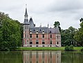
Aertrycke castle

Church: Sint Pietersbandenkerk

Watertower in Berg op Zoom


References[]
- ^ "Wettelijke Bevolking per gemeente op 1 januari 2018". Statbel. Retrieved 9 March 2019.
External links[]
 Media related to Torhout at Wikimedia Commons
- Official website - Information available in Dutch and limited information available in French, English and German
| show Places adjacent to Torhout |
|---|

| show Authority control |
|---|
This West Flanders location article is a stub. You can help Wikipedia by . |
- Torhout
- Municipalities of West Flanders
- West Flanders geography stubs