Liry
show This article may be expanded with text translated from the corresponding article in French. (December 2008) Click [show] for important translation instructions. |
Liry | |
|---|---|
Commune | |
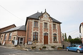 The town hall in Liry | |
 Coat of arms | |
show Location of Liry | |
 Liry | |
| Coordinates: 49°18′30″N 4°39′35″E / 49.3083°N 4.6597°ECoordinates: 49°18′30″N 4°39′35″E / 49.3083°N 4.6597°E | |
| Country | France |
| Region | Grand Est |
| Department | Ardennes |
| Arrondissement | Vouziers |
| Canton | Attigny |
| Intercommunality | Argonne Ardennaise |
| Government | |
| • Mayor (2020–2026) | Jacques Bouillon[1] |
| Area 1 | 12.69 km2 (4.90 sq mi) |
| Population (Jan. 2018)[2] | 87 |
| • Density | 6.9/km2 (18/sq mi) |
| Time zone | UTC+01:00 (CET) |
| • Summer (DST) | UTC+02:00 (CEST) |
| INSEE/Postal code | 08256 /08400 |
| 1 French Land Register data, which excludes lakes, ponds, glaciers > 1 km2 (0.386 sq mi or 247 acres) and river estuaries. | |


Liry is a commune in the Ardennes department in northern France.
Population[]
| Year | Pop. | ±% |
|---|---|---|
| 1962 | 109 | — |
| 1968 | 145 | +33.0% |
| 1975 | 119 | −17.9% |
| 1982 | 119 | +0.0% |
| 1990 | 106 | −10.9% |
| 1999 | 96 | −9.4% |
| 2008 | 107 | +11.5% |
See also[]
References[]
- ^ "Répertoire national des élus: les maires". data.gouv.fr, Plateforme ouverte des données publiques françaises (in French). 2 December 2020.
- ^ "Populations légales 2018". INSEE. 28 December 2020.
| Wikimedia Commons has media related to Liry. |
This Ardennes geographical article is a stub. You can help Wikipedia by . |
Categories:
- Communes of Ardennes (department)
- Ardennes (department) geography stubs