List of Cultural Properties of Japan - paintings (Fukushima)
This list is of the Cultural Properties of Japan designated in the category of paintings (絵画, kaiga) for the Prefecture of Fukushima.[1]
National Cultural Properties[]
As of 1 July 2020, five Important Cultural Properties have been designated, being of national significance.[2][3][4]
| Property | Date | Municipality | Ownership | Comments | Image | Dimensions | Coordinates | Ref. |
|---|---|---|---|---|---|---|---|---|
| Descent of Amida with Twenty-Five Bodhisattvas, colour on silk 絹本著色阿弥陀二十五菩薩来迎図 kenpon chakushoku Amida nijūgo bosatsu raigō zu |
Kamakura period | Aizuwakamatsu | Fukushima Museum |  |
37°29′20″N 139°56′05″E / 37.488761°N 139.934621°E | [1] | ||
| Miroku, colour on silk 絹本著色弥勒菩薩像 kenpon chakushoku Miroku bosatsu zō |
C13 | Iwaki | Yakuōji (薬王寺) |  |
155 centimetres (61 in) by 58.8 centimetres (23.1 in) | 37°06′57″N 140°55′07″E / 37.115769°N 140.918643°E | [2] | |
| Gamō Ujisato, colour on paper 紙本著色蒲生氏郷像 shihon chakushoku Gamō Ujisato zō |
1621 | Aizuwakamatsu | Saikōji (西光寺) (kept at Fukushima Museum) |
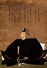 |
37°29′20″N 139°56′05″E / 37.488761°N 139.934621°E | [3] | ||
| Famous Places in the Eastern Capital, copperplates by 銅版画東都名所図〈亜欧堂田善筆/(二十五図)〉 dōhanga tōto meisho zu |
1748–1822 | Sukagawa | (須賀川市立博物館) | series of twenty-five prints; the designation includes a sample book[5] |  |
37°17′29″N 140°22′45″E / 37.291382°N 140.379170°E | [4] [5] | |
| Amida Triad, colour on silk 絹本著色阿弥陀三尊像 kenpon chakushoku Amida sanzon zō |
C13 | Taitō, Tokyo | Iwaki City (kept at the Tokyo National Museum) |
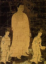 |
323.5 centimetres (127.4 in) by 166.8 centimetres (65.7 in) | 35°43′08″N 139°46′35″E / 35.718817°N 139.776478°E | [6] |

Prefectural Cultural Properties[]
As of 18 February 2020, twenty-seven properties have been designated at a prefectural level.[4]
| Property | Date | Municipality | Ownership | Comments | Image | Dimensions | Coordinates | Ref. |
|---|---|---|---|---|---|---|---|---|
| Shichirigahama, colour on silk 絹本著色七里ヶ浜図 kenpon chakushoku Shichirigahama zu |
1748–1822 | Koori | (種徳美術館) | by (亜欧堂田善) | 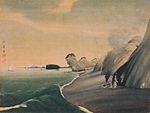 |
37°50′36″N 140°31′07″E / 37.843359°N 140.518516°E | for all refs see [7] | |
| Bamboo, flowers, and birds, colour with gold ground on paper 紙本金地著色叢竹花鳥図 shihon kinji chakushoku muratake kachō zu |
Edo period | Koori | (種徳美術館) | pair of six-panel byōbu | 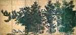  |
37°50′36″N 140°31′07″E / 37.843359°N 140.518516°E | ||
| Poetry Gathering at the Orchid Pavilion 蘭亭曲水図 rantei kyokusui zu |
late Edo period | Date | (伊達市保原歴史文化資料館) | by (熊坂適山) | 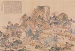 |
56.3 centimetres (22.2 in) by 84.3 centimetres (33.2 in) | 37°49′11″N 140°34′11″E / 37.819675°N 140.569811°E | |
| Southerly View of , ema 絵馬佃島南望之図 ema Tsukuda-shima nanbō no zu |
late Edo period | Kōriyama | (田村神社) | by (遠藤田一) | 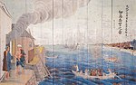 |
37°24′30″N 140°24′51″E / 37.408472°N 140.414240°E | ||
| Mount Ōe, ema 絵馬大江山図 ema Ōeyama zu |
Kōriyama | (田村神社) | 37°24′30″N 140°24′51″E / 37.408472°N 140.414240°E | |||||
| Three Great Personages from Records of the Three Kingdoms, ema 絵馬三国志三傑図 ema Sangokushi sanketsu zu |
Kōriyama | (田村神社) | 37°24′30″N 140°24′51″E / 37.408472°N 140.414240°E | |||||
| , colour on silk 絹本著色亜欧堂田善画像 kenpon chakushoku Aōdō Denzen gazō |
1822 | Sukagawa | private | by (遠藤田一) | 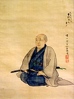 |
|||
| Hanawa Hokiichi, colour on silk 絹本著色塙保己一像 kenpon chakushoku Hanawa Hokiichi zō |
1821 | Iwaki | private | 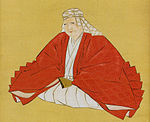 |
172.7 centimetres (68.0 in) by 55.7 centimetres (21.9 in) | 36°53′37″N 140°45′27″E / 36.893514°N 140.757372°E |
| show Cultural Properties of Japan - paintings |
|---|

See also[]
- Cultural Properties of Japan
- List of National Treasures of Japan (paintings)
- Japanese painting
- List of Historic Sites of Japan (Fukushima)
- List of Places of Scenic Beauty of Japan (Fukushima)
References[]
- ^ "Cultural Properties for Future Generations". Agency for Cultural Affairs. Retrieved 9 July 2020.
- ^ 国宝・重要文化財 [Number of National Treasures and Important Cultural Properties by Prefecture] (in Japanese). Agency for Cultural Affairs. 1 July 2020. Retrieved 9 July 2020.
- ^ "Database of National Cultural Properties: 国宝・重要文化財(美術品)(絵画 福島県)" (in Japanese). Agency for Cultural Affairs. Retrieved 9 July 2020.
- ^ Jump up to: a b 国指定(登録・選定・選択)・県指定(選定)文化財地域別件数 [Number of National and Prefectural Cultural Properties] (PDF) (in Japanese). Fukushima Prefecture. 18 February 2020. Retrieved 9 July 2020.
- ^ 銅版画見本帖〈亜欧堂田善筆/(十二図)〉 [Copperplate sample book] (in Japanese). Agency for Cultural Affairs. Retrieved 26 July 2014.
External links[]
- (in Japanese) Cultural Properties in Fukushima Prefecture
Categories:
- Japanese paintings
- Fukushima Prefecture
- Lists of Cultural Properties of Japan