List of Cultural Properties of Japan - structures (Hokkaidō)
This list is of the Cultural Properties of Japan designated in the category of structures (建造物, kenzōbutsu) for the Circuit of Hokkaidō.[1]
National Cultural Properties[]
As of 1 July 2019, thirty Important Cultural Properties with sixty-nine component structures have been designated, being of national significance.[2][3][4][5]
| Property | Date | Municipality | Comments | Image | Coordinates | Ref. |
|---|---|---|---|---|---|---|
| Iai Gakuin (Former Iai Girls School) 遺愛学院(旧遺愛女学校) Iai gakuin (kyū-Iai jo-gakkō) |
1908 | Hakodate | designation comprises two components: the main building and former missionary building | 41°47′13″N 140°45′26″E / 41.78705694°N 140.75734441°E | [1] [2] | |
| Former Asahikawa Officers' Clubhouse 旧旭川偕行社 kyū-Asahikawa kaikōsha |
1902 | Asahikawa | now the Asahikawa Museum of Sculpture |  |
43°48′20″N 142°21′52″E / 43.80558911°N 142.36431901°E | [3] |
旧下ヨイチ運上家 kyū-Shimoyoichi unjōya |
1853 | Yoichi | 43°11′52″N 140°47′17″E / 43.19788747°N 140.78816085°E | [4] | ||
旧花田家番屋(北海道留萌郡小平町) kyū-Hanada-ke banya (Hokkaidō Rumoi-gun Obira-chō) |
1905 | Obira | 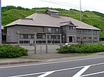 |
44°08′14″N 141°39′19″E / 44.13710644°N 141.65530403°E | [5] | |
旧開拓使工業局庁舎 kyū-Kaitakushi kōgyō-kyoku chōsha |
1877 | Sapporo | now within the Historical Village of Hokkaido[6] |  |
43°02′51″N 141°29′56″E / 43.04736948°N 141.49893428°E | [6] |
旧笹浪家住宅(北海道檜山郡上ノ国町) kyū-Sasanami-ke jūtaku (Hokkaidō Hiyama-gun Kaminokuni-chō) |
1801-1900 | Kaminokuni | designation comprises three components: the main building (C19), earthen warehouse (1885), and rice storehouse and archive (1848) | 41°48′12″N 140°06′16″E / 41.80340534°N 140.10432497°E | [7] [8] [9] | |
| Former Sapporo Agricultural College Drill Hall Clock Tower 旧札幌農学校演武場(時計台) kyū-Sapporo nōgakkō enbujō (tokei-dai) |
1878 | Sapporo | the bell is one of the 100 Soundscapes of Japan |  |
43°03′45″N 141°21′13″E / 43.0625588°N 141.35353324°E | [10] |
旧三戸部家住宅(北海道有珠郡伊達町) kyū-Mitobe-ke jūtaku (Hokkaidō Usu-gun Date-chō) |
1887 (circa) | Date |  |
42°28′23″N 140°52′30″E / 42.47293847°N 140.8750337°E | [11] | |
| Former Temiya Railway Facilities 旧手宮鉄道施設 kyū-Temiya tetudō shisetsu |
1868-1919 | Otaru | designation comprises six components: the No. 1 Locomotive Shed (機関車庫一号) (c. 1908), No. 3 Locomotive Shed (機関車庫三号) (1885), Storehouse for Dangerous Goods (危険品庫) (pre-1898), Water Tower (貯水槽) (pre-1916), Turntable (転車台) (1919), and Retaining Wall (擁壁) (1868-1911) | 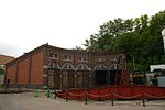 |
43°12′43″N 141°00′01″E / 43.21190863°N 141.00037116°E | [12][13][14][15][16][17] |
旧双葉幼稚園園舎 kyū-Futaba yōchien ensha |
1922 | Obihiro | 42°55′21″N 143°12′40″E / 42.92256583°N 143.21122194°E | [18] | ||
旧中村家住宅(北海道檜山郡江差町) kyū-Nakamura-ke jūtaku (Hokkaidō Hiyama-gun Esashi-chō) |
1830-1889 | Esashi | designation comprises three components: the Main Building (c. 1889) and two storage buildings (one of c. 1889, the other from the end of the Edo period) | 41°52′09″N 140°07′44″E / 41.86909424°N 140.1287878°E | [19][20][21] | |
| Former Nippon Yūsen Otaru Branch Building 旧日本郵船株式会社小樽支店 kyū-Nippon Yūsen kabushiki kaisha Otaru shiten |
1905 | Otaru |  |
43°12′26″N 140°59′54″E / 43.20727415°N 140.99830789°E | [22] | |
旧函館区公会堂 kyū-Hakodate-ku kōkaidō) |
1910 | Hakodate | designation comprises two components: the Main Building and Annex |  |
41°45′54″N 140°42′32″E / 41.76504812°N 140.708939°E | [23][24] |
旧本間家住宅 kyū-Homma-ke jūtaku |
1893-1902 | Mashike | designation comprises five components: the Main Building (1902), Store (1893), Annex (c. 1894), Clothing Warehouse (c. 1893), and Brewing Warehouse (c. 1894) |  |
43°51′27″N 141°31′30″E / 43.85743585°N 141.52505762°E | [25][26][27][28][29] |
| Old Abashiri Prison 旧網走監獄 kyū-Abashiri kangoku |
1912 | Abashiri | designation comprises three components: the Administration Building, Prison House and Central Guard House, and Lecture Hall; now part of the Abashiri Prison Museum (博物館網走監獄) |  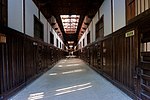  |
43°59′44″N 144°13′45″E / 43.995681°N 144.229291°E | [30][31][32] |
| Old Abashiri Prison (Futamigaoka Branch) 旧網走刑務所二見ヶ岡刑務支所(二見ヶ岡農場) kyū-Abashiri keimusho Futamigaoka keimushisho (Futamigaoka nōjō) |
1896-1930 | Abashiri | designation comprises five components: the Administration Building (1896), Prison House (1896), Lecture Hall and Cafeteria (1926), Building for Chaining and Unchaining (1930), and Kitchen (1896); now part of the Abashiri Prison Museum (博物館網走監獄) |  |
43°59′49″N 144°13′53″E / 43.997013°N 144.231257°E | [33][34][35][36][37] |
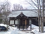
| Jōkoku-ji Hondō 上國寺本堂 Jōkokuji hondō |
1758 | Kaminokuni | 41°48′12″N 140°06′12″E / 41.80337204°N 140.1033182°E | [38] | ||
| Shōgyō-ji Hondō 正行寺本堂 Shōgyōji hondō |
1799 | Akkeshi | 43°02′09″N 144°50′48″E / 43.03596183°N 144.84669424°E | [39] | ||
太刀川家住宅店舗(北海道函館市弁天町) Tachikawa-ke jūtaku tenpo (Hokkaidō Hakodate-shi Benten-chō) |
1900 | Hakodate |  |
41°46′17″N 140°42′31″E / 41.77131771°N 140.70855274°E | [40] | |
| Ōtani-ha Hongan-ji Hakodate Betsu-in 大谷派本願寺函館別院 Ōtani-ha Honganji Hakodate betsuin |
1912-25 | Hakodate | designation comprises three components: the Hondō (1915), Shōrō (1912-25), and Main Gate (1912-25) |  |
41°45′47″N 140°42′50″E / 41.76297283°N 140.71395981°E | [41][42][43] |
| of the Orthodox Church in Hakodate 函館ハリストス正教会復活聖堂 Hakodate Harisutosu seikyōkai fukkatsu seidō |
1916 | Hakodate | the sound of the church bell is one of the 100 Soundscapes of Japan |  |
41°45′46″N 140°42′44″E / 41.76281284°N 140.71223236°E | [44] |
| Hassō-an 八窓庵 Hassōan |
Edo period (early) | Sapporo |  |
43°02′47″N 141°21′09″E / 43.04639149°N 141.35247412°E | [45] | |
| Matsumae Castle Honmaru Gate 福山城(松前城)本丸御門 Fukuyama-jō (Matsumae-jō) honmaru gomon |
1853 | Matsumae |  |
41°25′47″N 140°06′29″E / 41.42969676°N 140.10810811°E | [46] | |
| Sanmon 法源寺山門 Hōgen-ji sanmon |
Edo period (middle) | Matsumae | 41°25′53″N 140°06′27″E / 41.43151526°N 140.10755472°E | [47] | ||
| Hōheikan 豊平館 Hōheikan |
1880 | Sapporo |  |
43°02′47″N 141°21′09″E / 43.04628141°N 141.35257398°E | [48] | |
| Hokkaido University School of Agriculture (Former Tōhoku Imperial University Agricultural College Farm 2 北海道大学農学部(旧東北帝国大学農科大学)第二農場 Hokkaidō Daigaku nōgakubu (kyū-Tōhoku Teikoku Daigaku Nōka Daigaku) dai ni nōjō |
1877-1911 | Sapporo | designation comprises nine components |  |
43°03′49″N 141°20′35″E / 43.06348876°N 141.34313049°E | [49][50][51][52][53][54][55][56][57] |
| Hokkaido University School of Agriculture Botanical Gardens and Museum 北海道大学農学部植物園・博物館 Hokkaidō Daigaku nōgakubu shokubutsu-en・hakubutsukan |
1882-1911 | Sapporo | designation comprises four components: the Main Building (1882), Offices (1900), Storage Building (1884), and Botanical Garden Gatehouse (1911) |     |
43°03′49″N 141°20′35″E / 43.06348876°N 141.34313049°E | [58][59][60][61] |
| Former Hokkaidō Government Office 北海道庁旧本庁舎 Hokkaidō-chō kyū-honchōsha |
Edo period (early) | Sapporo |  |
43°03′50″N 141°20′53″E / 43.06396711°N 141.34800414°E | [62] | |
| Ryūun-in 龍雲院 Ryūun-in |
1842 | Matsumae | designation comprises five components: the Hondō and Kitchen of 1842, Shōrō of 1846, Sōmon of 1851, and Storehouse, which pre-dates 1846 | 41°25′53″N 140°06′25″E / 41.43131622°N 140.10701897°E | [63][64][65][66][67] | |
旧相馬家住宅 kyū-Sōma-ke jūtaku |
Meiji period (end) | Hakodate | designation comprises two components: the Main Building and Storehouse |  |
41°45′55″N 140°42′39″E / 41.765262°N 140.710898°E | [68] |

Prefectural Cultural Properties[]
As of 1 May 2019, twenty-five properties with the same number of component structures have been designated at a prefectural level.[4][7][8]


Municipal Cultural Properties[]
As of 1 May 2019, one hundred and eleven properties with one hundred and eighteen component structures have been designated at a municipal level.[10][11]
| Property | Date | Municipality | Comments | Image | Coordinates | Ref. |
|---|---|---|---|---|---|---|
華月館 Kagetsukan |
1897 | Takikawa | 43°33′54″N 141°55′28″E / 43.564897°N 141.924546°E | for all refs see [90] |
Registered Cultural Properties[]
As of 1 September 2016, one hundred and forty-three properties have been registered (as opposed to designated) at a national level.[12][13][14]
| Property | Date | Municipality | Comments | Image | Coordinates | Ref. |
|---|---|---|---|---|---|---|
| JR Otaru Station Main Building JR小樽駅本屋 JR Otaru-eki honya |
1934 | Otaru |  |
43°11′52″N 140°59′37″E / 43.19764691°N 140.99372864°E | [91] | |
| Iai Gakuin (Former Iai Girls School) Shaonkan 遺愛学院(旧遺愛女学校)謝恩館 Iai Gakuin (kyū-Iai jo-gakkō) Shaonkan |
1922 | Hakodate | extended in 1961 | 41°47′14″N 140°45′28″E / 41.787235°N 140.757645°E | [92] | |
| Iai Gakuin Chapel 遺愛学院講堂 Iai Gakuin kōdō |
1935 | Hakodate |  |
41°47′15″N 140°45′26″E / 41.787518°N 140.757172°E | [93] | |
| Edwin Dun エドウィン・ダン記念館(旧北海道庁真駒内種畜場事務所) Edōin Dan Kinenkan (kyū-Hokkaidō-chō Makomanai shuchikujō jimusho) |
1887 | Sapporo | relocated in 1964 |  |
42°59′20″N 141°21′09″E / 42.98898587°N 141.35236232°E | [94] |
| Former Japanese National Railways 旧国鉄根北線越川橋梁 kyū-Kokutetsu Konpoku-sen Koshikawa kyōryō |
1940 | Shari | a ten-arch 147 metres (482 ft) long 21.7 metres (71 ft) high concrete railway bridge, the largest on the island; never complete, two piers were removed during work on Japan National Route 244 in 1973 |  |
43°50′12″N 144°47′28″E / 43.836672°N 144.791079°E | [95] |
| show Cultural Properties of Japan - structures |
|---|


See also[]
- Cultural Properties of Japan
- National Treasures of Japan
- List of Historic Sites of Japan (Hokkaidō)
- List of Cultural Properties of Japan - paintings (Hokkaidō)
- Hokkaido Museum
- Historical Village of Hokkaido
References[]
- ^ "Cultural Properties for Future Generations". Agency for Cultural Affairs. Retrieved 16 September 2019.
- ^ 国宝・重要文化財 [Number of National Treasures and Important Cultural Properties by Prefecture] (in Japanese). Agency for Cultural Affairs. 1 July 2019. Retrieved 16 September 2019.
- ^ 国宝・重要文化財(美術品)(建造物 北海道) [Database of National Cultural Properties] (in Japanese). Agency for Cultural Affairs. Archived from the original on 30 June 2019. Retrieved 16 September 2019.
- ^ Jump up to: a b 北海道の指定文化財件数一覧 [Number of Cultural Properties in Hokkaido] (in Japanese). Hokkaido Government Board of Education. 29 March 2019. Retrieved 16 September 2019.
- ^ 国の指定・選定文化財一覧 [List of National Cultural Properties] (in Japanese). Hokkaido Government Board of Education. 31 July 2019. Retrieved 16 September 2019.
- ^ 開拓の村 マップ [Map] (in Japanese). Historical Village of Hokkaido. Retrieved 9 October 2016.
- ^ 都道府県別指定等文化財件数(都道府県分) [Number of Prefectural Cultural Properties by Prefecture] (in Japanese). Agency for Cultural Affairs. 1 May 2019. Retrieved 16 September 2019.
- ^ 北海道指定の文化財一覧 [List of Hokkaido Prefectural Cultural Properties] (in Japanese). Hokkaido Government Board of Education. 5 September 2019. Retrieved 16 September 2019.
- ^ 【北海道指定有形文化財】上ノ國八幡宮本殿 [Hokkaidō Prefectural Tangible Cultural Properties: Kaminokuni Hachimangū Honden] (in Japanese). Kaminokuni Town. Retrieved 15 June 2019.
- ^ 都道府県別指定等文化財件数(市町村分) [Number of Municipal Cultural Properties by Prefecture] (in Japanese). Agency for Cultural Affairs. 1 May 2019. Retrieved 16 September 2019.
- ^ 市町村指定文化財一覧 [List of Municipal Cultural Properties] (in Japanese). Hokkaido Government Board of Education. 1 May 2016. Retrieved 8 October 2016.
- ^ 登録文化財 [Number of Registered Cultural Properties by Prefecture] (in Japanese). Agency for Cultural Affairs. 1 September 2016. Retrieved 8 October 2016.
- ^ 登録有形文化財 (美術品) (歴史資料 北海道) [Database of National Cultural Properties] (in Japanese). Agency for Cultural Affairs. Archived from the original on 22 July 2019. Retrieved 8 November 2015.
- ^ 国の登録文化財一覧 [List of National Registered Cultural Properties] (in Japanese). Hokkaido Government Board of Education. 5 July 2016. Retrieved 8 October 2016.
External links[]
- (in Japanese) Cultural Properties in Hokkaido
Categories:
- Architecture of Japan
- Buildings and structures in Hokkaido
- Lists of buildings and structures in Japan by prefecture
- Lists of Cultural Properties of Japan