Matsumae, Hokkaido
This article includes a list of general references, but it remains largely unverified because it lacks sufficient corresponding inline citations. (June 2017) |
Matsumae
松前町 | |
|---|---|
Town | |
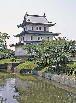 Matsumae Castle (July 2004) | |
 Flag | |
 Location of Matsumae in Oshima Subprefecture, Hokkaido | |
 Matsumae Location in Japan | |
| Coordinates: 41°26′N 140°7′E��� / 41.433°N 140.117°ECoordinates: 41°26′N 140°7′E / 41.433°N 140.117°E | |
| Country | Japan |
| Prefecture | Hokkaido |
| District | Matsumae |
| Government | |
| • Mayor | Hideo Ishiyama (石山 英雄) |
| Area | |
| • Total | 293.11 km2 (113.17 sq mi) |
| Population (2016) | |
| • Total | 7,843 |
| • Density | 27/km2 (69/sq mi) |
| Time zone | UTC+09:00 (JST) |
| Postal code(s) | 049-1592 |
| Area code(s) | 0139 |
| City hall address | Aza Fukiyama 248, Matsumae-chō, Matsumae-gun, Hokkaidō 049-1592 |
| Website | www |
| Symbols | |
| Flower | Cherry blossom |
| Tree | Pine |

Matsumae (松前町, Matsumae-chō) is a town located in Oshima Subprefecture, Hokkaido, Japan. The former home of the Matsumae Han, it has an Edo period castle, Matsumae Castle, the only one in Hokkaido, and Ryūun-in.
The total area of the town is 293.11 square kilometres (113.17 sq mi).
History[]
- 1900: Fukuyama town was founded.
- 1940: Fukuyama changed its name to Matsumae.
- 1953: Matsumae Line opened.
- 1954: Matsumae town, Oshima village, Osawa village, and Kojima village were merged to form Matsumae town.
- 1988: Matsumae Line was abolished.[1]
Geography[]
The town is located on the southern end of the Matsumae Peninsula. In addition the town governs the two islands in the Tsugaru Strait, Oshima and Kojima.[2]
Along with Kaminokuni, Hokkaido, and Fukushima, Hokkaido, Matsumae shares a border with Mount Daisengen, and contains the newest and shortest climbing route to the summit of the mountain.[3]
Demographics[]
As of September 2016, the town has an estimated population of 7,843 and a density of 26.7 persons per km2.
Culture and lifestyle[]
Surrounding Matsumae Castle is Matsumae Park, which features over 10,000 cherry trees of over 250 varieties, and is ranked among the top cherry blossom viewing spots in the country.[4]
Education[]
High school[]
- Hokkaido Matsumae High School (the southernmost high school in Hokkaido)[5]
Sister cities[]
- Omihachiman, Shiga (since 1984) [6]
- Masaki, Ehime (since 1990) [7]
- Date, Fukushima (since 2011) [8]
References[]
- ^ Matsumae Line Archived 2015-02-27 at the Wayback Machine
- ^ "gotyuuikudasai" (in Japanese). 松前町役場. Archived from the original on 15 July 2010. Retrieved 30 June 2010.
- ^ "大千軒岳情報 | 渡島総合振興局森林室西部森林室". www.oshima.pref.hokkaido.lg.jp. Retrieved 2020-07-14.
- ^ "Matsumae". www.japan-guide.com. Retrieved 2020-07-14.
- ^ Hokkaido Matsumae High School
- ^ Sister cities of Omihachiman
- ^ Interaction with sister city, Matsumae
- ^ Sister cities of Date
External links[]
![]() Media related to Matsumae, Hokkaidō at Wikimedia Commons
Media related to Matsumae, Hokkaidō at Wikimedia Commons
- Official Website (in Japanese)
| show |
|---|
| show Authority control |
|---|
- Matsumae, Hokkaido
- Towns in Hokkaido