List of Important Cultural Properties of Japan (Taishō period: structures)
This list is of Japanese structures dating from the Taishō period (1912–1926) that have been designated Important Cultural Properties.[1] As of October 2016, ninety-six properties with two hundred and twenty-seven component structures have been so designated.[2]
Structures[]
| Structure | Date | Municipality | Prefecture | Comments | Image | Coordinates | Ref. |
|---|---|---|---|---|---|---|---|
旧手宮鉄道施設 kyū-Temiya tetsudō shisetsu |
1916-19 | Otaru | Hokkaido | designation comprises six components, two from the Taishō period: the water tank (1916) and turntable (1919) |  |
43°12′43″N 141°00′01″E / 43.21190863°N 141.00037116°E | [1] [2] |
| Ōtani Hongan-ji Hakodate Betsu-in 大谷派本願寺函館別院 Ōtani-ha Honganji Hakodate betsu-in |
1912-25 | Hakodate | Hokkaido | designation comprises three components: the hondō (1915), shōrō, and main gate |  |
41°45′47″N 140°42′50″E / 41.76297283°N 140.71395981°E | [3] [4] [5] |
函館ハリストス正教会復活聖堂 Hakodate Harisutosu seikyōkai fukkatsu seidō |
1916 | Hakodate | Hokkaido | the sound of the church bell is one of the 100 Soundscapes of Japan |  |
41°45′46″N 140°42′44″E / 41.76281284°N 140.71223236°E | [6] |
| Iwate University Department of Agriculture 岩手大学農学部(旧盛岡高等農林学校) Iwate daigaku nōgakubu |
1912 | Morioka | Iwate | designation comprises two components, one from the Taishō period: the former main building (1912) |  |
39°42′49″N 141°08′20″E / 39.71350333°N 141.13876763°E | [7] |
旧高橋家住宅 kyū-Takahashi-ke jūtaku |
1924 | Ōshū | Iwate | designation comprises seven components, two from the Taishō period: two storehouses (1924) | 39°08′29″N 141°08′23″E / 39.14128347°N 141.1396203°E | [8] [9] | |
千葉家住宅 Chiba-ke jūtaku |
1912-25 | Tōno | Iwate | designation comprises five components, one from the Taishō period: the stone storehouse |  |
39°20′27″N 141°26′30″E / 39.34076665°N 141.44172789°E | [10] |
金家住宅 Kon-ke jūtaku |
1913-25 | Kitaakita | Akita | designation comprises four components, two from the Taishō period: the western-style residence (1925) and rice storehouse (1913) | 40°07′45″N 140°20′55″E / 40.12921965°N 140.34872314°E | [11] [12] | |
小玉家住宅 Kodama-ke jūtaku |
1923 | Katagami | Akita | designation comprises four components: the residence, two storehouses, and garage | 39°53′44″N 140°04′43″E / 39.89563747°N 140.07858951°E | [13] [14] [15] [16] | |
鈴木家住宅 Suzuki-ke jūtaku |
1915 | Ugo | Akita | designation comprises two components, one from the Taishō period: the storehouse | 39°09′05″N 140°21′22″E / 39.15135546°N 140.35624542°E | [17] | |
山形県旧県庁舎及び県会議事堂 Yamagata-ken kyū-kenchōsha oyobi kenkaigijidō |
1916 | Yamagata | Yamagata | designation comprises two components: the Former Yamagata Prefectural Office and Former Yamagata Prefectural Assembly Hall |   |
38°15′24″N 140°20′28″E / 38.25679728°N 140.34118635°E | [18] [19] |
旧高松宮翁島別邸 kyū-Takamatsunomiya Okinashima bettei |
1922 | Inawashiro | Fukushima | designation comprises three components: two entrances and the kitchen | 37°31′03″N 140°02′40″E / 37.517585°N 140.04440658°E | [20] [21] [22] | |
横利根閘門 Yokotone kō-mon |
1921 | Inashiki | Ibaraki |  |
35°54′43″N 140°29′39″E / 35.91204494°N 140.49414408°E | [23] | |
石岡第一発電所施設 Ishioka dai-ichi hatsudensho shisetsu |
1916 | Takahagi | Ibaraki | designation comprises eight components, one from the Taishō period | 36°47′30″N 140°39′18″E / 36.79160108°N 140.65496273°E | [24] | |
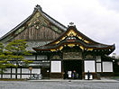
| Former Nikkō Tamozawa Imperial Villa 旧日光田母澤御用邸 kyū-Nikkō Tamozawa go-yōtei |
1912-25 | Nikkō | Tochigi | designation comprises ten components, three from the Taishō period: two audience chambers (1921) and a room for the ladies-in-waiting | 36°45′08″N 139°35′29″E / 36.75226281°N 139.59150267°E | [25] [26] [27] | |
碓氷峠鉄道施設 Usui-tōge tetsudō shisetsu |
1912 | Annaka | Gunma | designation comprises seventeen components, two from the Taishō period: the former Maruyama substation machinery and battery rooms; proposed for inscription on the UNESCO World Heritage List as a component of The Tomioka Silk Mill and Related Industrial Heritage |  |
36°21′18″N 138°42′20″E / 36.35511988°N 138.70551693°E | [28] [29] |
誠之堂 Seishidō |
1916 | Fukaya | Saitama | designed by Tanabe Junkichi (田辺淳吉) |  |
36°13′21″N 139°16′32″E / 36.22251641°N 139.27548844°E | [30] |
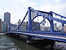
永代橋 Eitai-hashi |
1926 | Chūō | Tokyo | 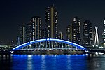 |
35°40′35″N 139°47′15″E / 35.67629725°N 139.78753602°E | [31] | |
旧磯野家住宅 kyū-Isono-ke jūtaku |
1912-13 | Bunkyō | Tokyo | designation comprises two components: the residence (1912) and front gate (1913) |  |
35°43′08″N 139°44′18″E / 35.71900907°N 139.73826313°E | [32] [33] |
旧三河島汚水処分場喞筒場施設 kyū-Mikawajima osuishobunjō bonbujō shisetsu |
1920-1 | Arakawa | Tokyo | designation comprises seven components |  |
35°44′17″N 139°47′07″E / 35.73802807°N 139.78520458°E | [34] [35] [36] [37] [38] [39] [40] |
旧渋沢家飛鳥山邸 kyū-Shibusawa-ke Asukayama-tei |
1918-25 | Kita | Tokyo | designation comprises two components: the Bankōro by Tanabe Junkichi (1918) and Seien Bunko Library (1925) |   |
35°44′56″N 139°44′24″E / 35.74883852°N 139.74002707°E | [41] [42] |
旧朝倉家住宅 kyū-Asakura-ke jūtaku |
1919 | Shibuya | Tokyo | designation comprises two components: the main building and storehouse |   |
35°38′51″N 139°42′03″E / 35.64751566°N 139.70090102°E | [43] [44] |
| Jiyu Gakuen Myōnichikan 自由学園明日館 Jiyu Gakuen Myōnichikan |
1921-5 | Toshima | Tokyo | designation comprises four components, three from the Taishō period: the central building (1921), west classroom building (1922), and east classroom building (1925) |  |
35°43′36″N 139°42′26″E / 35.72668075°N 139.70723087°E | [45] [46] [47] |
| Meiji Memorial Picture Gallery 聖徳記念絵画館 Seitoku kinen kaigakan |
1926 | Shinjuku | Tokyo | 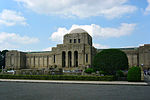 |
35°40′44″N 139°43′03″E / 35.67877212°N 139.71763049°E | [48] | |
| Sensō-ji Denbō-in 浅草寺伝法院 Sensōji Denbōin |
1918 | Taitō | Tokyo | designation comprises six components, two from the Edo period, three from the Meiji period, and one from the Taishō period: the new Shoin | 35°42′48″N 139°47′44″E / 35.71325522°N 139.79549036°E | [49] | |
| Tokyo Station Marunouchi Building 東京駅丸ノ内本屋 Tōkyō-eki Marunouchi honya |
1914 | Chiyoda | Tokyo |  |
35°40′53″N 139°45′58″E / 35.6813841°N 139.76601016°E | [50] | |
| Meiji Jingū Treasure Museum 明治神宮宝物殿 Meiji Jingū hōmotsuden |
1921 | Shibuya | Tokyo | designation comprises thirteen components: the central, east, and west treasure houses, east and west corridors, east and west bridges, east and west crossings, north building, covered driveway, office, and main gate |   |
35°40′48″N 139°41′53″E / 35.67994525°N 139.69798693°E | [51] [52] [53] [54] [55] [56] [57] [58] [59] [60] [61] [62] [63] |
| Yokohama Port Opening Memorial Hall 横浜市開港記念会館 Yokohama-shi kaikō kinen kaikan |
1917 | Yokohama | Kanagawa |  |
35°26′50″N 139°38′28″E / 35.44727244°N 139.64110417°E | [64] | |
五十嵐家住宅 Igarashi-ke jūtaku |
1924 | Aga | Niigata | designation comprises three components, one from the Taishō period: a storehouse | 37°44′37″N 139°37′07″E / 37.74365141°N 139.61856327°E | [65] | |
佐藤家住宅 Satō-ke jūtaku |
1926 | Sekikawa | Niigata | designation comprises six components, one from the Taishō period: the new living room | 38°05′25″N 139°33′48″E / 38.09025365°N 139.56337511°E | [66] | |
白岩堰堤砂防施設 Shiraiwa entei sabō shisetsu |
1919 | Toyama | Toyama | designation comprises four components, one from the Taishō period: a side dam |  |
36°32′55″N 137°32′04″E / 36.54851948°N 137.53453884°E | [67] |
旧金澤陸軍兵器支廠 kyū-Kanazawa rikugun heikishō |
1913-4 | Kanazawa | Ishikawa | designation comprises three components, two from the Taishō period: the sixth (1913) and seventh (1914) arsenal buildings; now the Ishikawa Prefectural History Museum |  |
36°33′30″N 136°39′45″E / 36.55845265°N 136.66246229°E | [68] [69] |
忠谷家住宅 Chūya-ke jūtaku |
1915 | Kaga | Ishikawa | designation comprises four components, two from the Taishō period: the new living room and new storehouse | 36°21′04″N 136°18′28″E / 36.35118126°N 136.30781967°E | [70] [71] | |
中村家住宅 Nakamura-ke jūtaku |
1913 | Minamiechizen | Fukui | designation comprises ten components, one from the Taishō period: the new living room | 35°49′38″N 136°04′04″E / 35.82714224°N 136.06790956°E | [72] | |
八ツ沢発電所施設 Yatsusawa hatsudensho shisetsu |
1915 | Ōtsuki, Uenohara | Yamanashi | designation comprises twenty components, three from the Taishō period: the Ōno regulating pond dam, floodgate, and spillway |  |
35°36′49″N 138°57′45″E / 35.613585°N 138.96238516°E | [73] [74] [75] |
旧松本高等学校 kyū-Matsumoto kōtō gakkō |
1920-2 | Matsumoto | Nagano | designation comprises two components: the main building (1920) and auditorium (1922) |  |
36°13′52″N 137°58′55″E / 36.23113197°N 137.98191708°E | [76] [77] |
旧常田館製糸場施設 kyū-Tokidakan seishijō shisetsu |
1912 | Ueda | Nagano | designation comprises seven components, two from the Taishō period: the five-storey cocoon warehouse and cocoon processing building | 36°23′38″N 138°15′19″E / 36.3938401°N 138.25533018°E | [78] [79] | |
牛伏川本流水路(牛伏川階段工) Ushibuse-gawa honryū suiro (Ushibuse-gawa kaidankō) |
1917 | Matsumoto | Nagano |  |
36°09′41″N 138°01′21″E / 36.16149921°N 138.02251975°E | [80] | |
読書発電所施設 Yomikaki hatsudensho shisetsu |
1922-3 | Nagiso | Nagano | designation comprises three components: the power plant (1922-3), Kakizore aqueduct (1923), and Momosuke bridge (1922) |    |
35°35′17″N 137°35′31″E / 35.58806458°N 137.59195596°E | [81] [82] [83] |
美濃橋 Mino-hashi |
1920 | Mino | Gifu |  |
35°33′08″N 136°54′38″E / 35.5521254°N 136.91064104°E | [84] | |
旧額田郡公会堂及物産陳列所 kyū-Nukada-kun kōkaidō oyobi Bussan chinretsusho |
1913 | Okazaki | Aichi | designation comprises two components |  |
34°57′12″N 137°10′35″E / 34.95331919°N 137.17632101°E | [85] [86] |
旧名古屋控訴院地方裁判所区裁判所庁舎 kyū-Nagoya kōsoin chihōsaibansho kusaibansho chōsha |
1922 | Nagoya | Aichi | now the Nagoya City Archives |  |
35°10′53″N 136°54′37″E / 35.18125338°N 136.91029986°E | [87] |
豊橋ハリストス正教会聖使徒福音者馬太聖堂 Toyohashi Harisutosu seikyōkai seishito fukuinsha matai seidō |
1913 | Toyohashi | Aichi |  |
34°46′05″N 137°23′39″E / 34.76806742°N 137.39408224°E | [88] | |
旧諸戸家住宅 kyū-Moroto-ke jūtaku |
1912-13 | Kuwana | Mie | designation comprises two components: the Japanese-style (1912) and Western-style (1913) buildings |   |
35°04′16″N 136°41′34″E / 35.07102499°N 136.69268121°E | [89] [90] |
旧伊庭家住宅 kyū-Iba-ke jūtaku |
1922 | Ōtsu | Shiga | designation comprises six components, one from the Taishō period: the new living room | 34°58′15″N 135°54′09″E / 34.97074345°N 135.90247334°E | [91] | |
蘆花浅水荘 Rokasansuisō |
1915-21 | Ōtsu | Shiga | designation comprises six components: the outhouse (1915), storehouse (1919), Jibutsudō (1920), and front gate, main building, and connecting corridor (1921) | 34°59′24″N 135°53′43″E / 34.99002129°N 135.89521134°E | [92] [93] [94] [95] [96] [97] | |
旧京都中央電話局西陣分局舎 kyū-Kyōto chūō denwa-kyoku Nishijin-bun kyokusha |
1921 | Kyoto | Kyoto |  |
35°01′29″N 135°45′12″E / 35.02479098°N 135.75339695°E | [98] | |
旧三井家下鴨別邸 kyū-Mitsui-ke Shimogamo bettei |
1912-26 | Kyoto | Kyoto | designation comprises three components, two from the Taishō period: the entrance building (1925) and chashitsu | 35°01′54″N 135°46′19″E / 35.0317384°N 135.7719041°E | [99] [100] | |
清風荘 Seifūsō |
1912-14 | Kyoto | Kyoto | designation comprises twelve components | 35°01′46″N 135°46′34″E / 35.02945068°N 135.77609436°E | [101] [102] [103] [104] [105] [106] [107] [108] [109] [110] [111] [112] | |
清流亭 Seiryūtei |
1913 | Kyoto | Kyoto | designation comprises three components | 35°00′49″N 135°47′27″E / 35.01348976°N 135.7908233°E | [113] [114] [115] | |
| Umekōji Roundhouse 梅小路機関車庫 Umekōji kikan shako |
1914 | Kyoto | Kyoto |  |
34°59′13″N 135°44′34″E / 34.98696968°N 135.74284927°E | [116] | |
舞鶴旧鎮守府水道施設 Maizuru kyū-chinjufu suidō shisetsu |
1921 | Maizuru | Kyoto | designation comprises ten components, one from the Taishō period: the water intake dam on the lower stretches of the Kishitani River | 35°26′44″N 135°26′37″E / 35.44551266°N 135.44362462°E | [117] | |
野村碧雲荘 Nomura Hekiunsō |
1921 | Kyoto | Kyoto | villa built for Tokushichi Nomura II in the grounds of Nanzen-ji; the gardens use water from Lake Biwa Canal; designation comprises seventeen components, including a Noh stage and chashitsu; six date from the Taishō era and the remainder from 1928 | 35°00′49″N 135°47′35″E / 35.01353526°N 135.79302579°E | [118] [119] [120] [121] [122] [123] | |
旧西尾家住宅 kyū-Nishio-ke jūtaku |
1926 | Suita | Osaka | designation comprises seven components, two from the Taishō period: the east and west wings | 34°45′24″N 135°31′24″E / 34.7565366°N 135.5234237°E | [124] [125] | |
大阪市中央公会堂 Ōsaka-shi chūō kōkaidō |
1918 | Osaka | Osaka |  |
34°41′37″N 135°30′14″E / 34.69354611°N 135.50400457°E | [126] | |
| Osaka Prefectural Library 大阪府立図書館 Ōsaka furitsu toshokan |
1922 | Osaka | Osaka | designation comprises three components, two from the Taishō period: the left and right wings |  |
34°41′37″N 135°30′12″E / 34.69361651°N 135.50324472°E | [127] [128] |
移情閣 Ijōkaku |
1915 | Kobe | Hyōgo |  |
34°37′48″N 135°02′04″E / 34.62999772°N 135.0345347°E | [129] | |
| Former Yamamura Family Residence 旧山邑家住宅(淀川製鋼迎賓館) kyū-Yamamura-ke jūtaku (Yodogawa seikō geihinkan) |
1924 | Ashiya | Hyōgo | by Frank Lloyd Wright |  |
34°44′23″N 135°18′00″E / 34.73984411°N 135.29993014°E | [130] |
旧村山家住宅 kyū-Murayama-ke jūtaku |
1912-26 | Kobe | Hyōgo | designation comprises six components, three from the Taishō period: the shoin (1918), entrance (1918), and art storehouse | 34°43′25″N 135°15′24″E / 34.72368512°N 135.25666529°E | [131] [132] [133] | |
| Nunobiki Water Source Facilities 布引水源地水道施設 Nunobiki suigen-chi suidō shisetsu |
1912-25 | Kobe | Hyōgo | designation comprises nine components, one from the Taishō period: the Tanigawa Bridge | 34°42′52″N 135°11′15″E / 34.71448884°N 135.18744859°E | [134] | |
| Hase-dera Honbō 長谷寺本坊 Hase-dera honbō |
1919-24 | Sakurai | Nara | designation comprises eight components, six from the Taishō period: the great lecture hall (1919), inner shoin (1920), large entrance and kuri, small shoin, and Gomadō (1923), and karamon and kairō (1924) |  |
34°32′01″N 135°54′28″E / 34.53358162°N 135.90789065°E | [135] [136] [137] [138] [139] [140] |
旧西村家住宅 kyū-Nishimura-ke jūtaku |
1914 | Shingū | Wakayama |  |
33°43′40″N 135°59′33″E / 33.72783104°N 135.99259141°E | [141] | |
琴ノ浦温山荘 Kotonoura Onzansō |
1913-20 | Kainan | Wakayama | designation comprises three components: the "hama-zashiki" (1913), main building (1915), and chashitsu (1920) |   |
34°09′30″N 135°11′40″E / 34.15825806°N 135.19450044°E | [142] [143] [144] |
旧美歎水源地水道施設 kyū-Mitani suigenchi entei suidō shisetsu |
1922 | Tottori | Tottori | designation comprises ten components, eight from the Taishō period: two weirs, four filtration ponds, and a well (1915) and the dam (1922) | 35°29′11″N 134°17′15″E / 35.48635487°N 134.28757652°E | [145] [146] [147] [148] [149] [150] [151] [152] | |
| Ishitani Family Residence 石谷家住宅 Ishitani-ke jūtaku |
1920-2 | Chizu | Tottori | designation comprises eight components, three from the Taishō period: three storehouses |  |
35°16′12″N 134°13′49″E / 35.27013223°N 134.23033923°E | [153] [154] [155] |
門脇家住宅 Kadowaki-ke jūtaku |
1914 | Daisen | Tottori | designation comprises four components, one from the Taishō period: the new storehouse | 35°29′01″N 133°27′57″E / 35.48353658°N 133.46587737°E | [156] | |
旧大社駅本屋 kyū-Taisha-eki honya |
1920 | Izumo | Shimane |  |
35°23′12″N 132°41′25″E / 35.38671219°N 132.69022887°E | [157] | |
旧大原家住宅 kyū-Ōhara-ke jūtaku |
1912-25 | Kurashiki | Okayama | designation comprises ten components, two from the Taishō period: two storehouses | 34°35′48″N 133°46′15″E / 34.59663246°N 133.77090814°E | [158] [159] | |
春風館賴家住宅 Shunbūkan Rai-ke jūtaku |
1917 | Takehara | Hiroshima | designation comprises five components, one from the Taishō period: a storehouse | 34°20′49″N 132°54′35″E / 34.34694237°N 132.90985191°E | [160] | |
本庄水源地堰堤水道施設 Honjō suigenchi entei suidō shisetsu |
1916 | Kure | Hiroshima | designation comprises three components: the dam and two wells |  |
34°18′25″N 132°33′44″E / 34.30681234°N 132.56208707°E | [161] [162] [163] |
旧毛利家本邸 kyū-Mōri-ke hontei |
1916-8 | Hōfu | Yamaguchi | designation comprises twelve components: the main building, gate, gatehouse, stone bridge, kitchen, bathroom, maids' room, and four storehouses (1916) and image hall (1918); partly occupied by the Mōri Museum |  |
34°03′48″N 131°35′15″E / 34.06337421°N 131.58746256°E | [164] [165] [166] [167] [168] [169] [170] [171] [172] [173] [174] [175] [176] |
山口県旧県庁舎及び県会議事�� Yamaguchi-ken kyū-kenchōsha oyobi kenkaigijidō |
1916 | Yamaguchi | Yamaguchi | designation comprises two components: the Former Yamaguchi Prefectural Office and Former Yamaguchi Prefectural Assembly Hall | 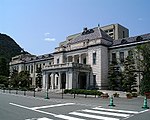 |
34°11′07″N 131°28′19″E / 34.1851821°N 131.47204959°E | [177] [178] |
有近家住宅 Arichika-ke jūtaku |
1923-4 | Yamaguchi | Yamaguchi | designation comprises seven components, three from the Taishō period: the main building and gate (1924) and warehouse (1923) | 34°13′53″N 131°39′48″E / 34.23147117°N 131.66324044°E | [179] [180] [181] | |
| (Former Matsudaira Takamatsu Villa) 披雲閣(旧松平家高松別邸) Hiunkaku (kyū-Matsudaira-ke Takamatsu bettei) |
1917-26 | Takamatsu | Kagawa | designation comprises three components: the main building (1917) and two storehouses (1917, 1926) |  |
34°21′01″N 134°03′06″E / 34.35040275°N 134.05161019°E | [182] [183] [184] |
| Daishidō 岩屋寺大師堂 Iwayaji Daishidō |
1920 | Kumakōgen | Ehime | Iwaya-ji is Temple 45 of the Shikoku pilgrimage |  |
33°39′32″N 132°58′51″E / 33.6587575°N 132.98077524°E | [185] |
| Dōgo Onsen Main Building 道後温泉本館 Dōgo onsen honkan |
1924 | Matsuyama | Ehime | designation comprises four components, two from the Taishō period: the south wing and entrance (1924) |  |
33°51′08″N 132°47′11″E / 33.85213473°N 132.78635339°E | [186] [187] |
内子座 Uchiko-za |
1916 | Uchiko | Ehime |  |
33°33′05″N 132°39′01″E / 33.55151914°N 132.65020433°E | [188] | |
豊島家住宅 Toshima-ke jūtaku |
1917 | Matsuyama | Ehime | designation comprises seven components, one from the Taishō period: the rice storehouse (1917) | 33°47′53″N 132°46′49″E / 33.7981607°N 132.78034331°E | [189] | |
| (Former Hisamatsu Family Villa) 萬翠荘(旧久松家別邸) Bansuisō (kyū-Hisamatsu-ke bettei) |
1922 | Matsuyama | Ehime | designation comprises two components: the main building and estate manager's lodge (1922) |  |
33°50′33″N 132°46′06″E / 33.84244628°N 132.76822861°E | [190] [191] |
旧関川家住宅 (高知県高知市一宮) kyū-Sekikawa-ke jūtaku (Kōchi-ken Kōchi-shi Ichinomiya) |
1912-25 | Kōchi | Kōchi | designation comprises four components, one from the Taishō period: the tool storehouse (1912–25) | 33°35′16″N 133°34′26″E / 33.58777219°N 133.57390179°E | [192] | |
旧魚梁瀬森林鉄道施設 kyū-Yanase shinrin tetsudō shisetsu |
1913-26 | Kōchi | designation includes fourteen component tunnels and bridges, four from the Meiji period, five from the Taishō period (Kamagatani Bridge (1926), Ochiai Bridge (1925), estuary tunnel (1913), Inubō Bridge (1924), and Inoya Bridge (1924)), and five from the Shōwa period | 33°29′15″N 134°00′09″E / 33.4874299°N 134.00262903°E | [193] [194] [195] [196] [197] | ||
旧門司三井倶楽部 kyū-Moji Mitsui kurabu |
1921 | Kitakyushu | Fukuoka | designation comprises two components: the main building and Fuzoku-ya (1921) |  |
33°56′45″N 130°57′45″E / 33.94573799°N 130.96255676°E | [198] [199] |
今村天主堂 Imamura tenshudō |
1913 | Tachiarai | Fukuoka |  |
33°22′14″N 130°35′57″E / 33.37066792°N 130.59913084°E | [200] | |
南河内橋 minami Kawachi bashi |
1926 | Kitakyushu | Fukuoka |  |
33°49′38″N 130°48′04″E / 33.82732552°N 130.80101755°E | [201] | |
| Mojikō Station Main Building 門司港駅 (旧門司駅) 本屋 Mojikō eki (kyū-Mojikō eki) honkan |
1914 | Kitakyushu | Fukuoka |  |
33°56′42″N 130°57′41″E / 33.94512386°N 130.96151453°E | [202] | |
| New Building and Rōmon 武雄温泉新館及び楼門 Takeo onsen shinkan oyobi rōmon |
1914 | Takeo | Saga | designation comprises two components: the new building and rōmon | 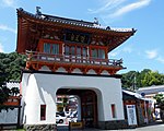 |
33°11′48″N 130°00′52″E / 33.19659911°N 130.0143848°E | [203] [204] |
旧佐世保無線電信所(針尾送信所)施設 kyū-Sasebo musen denshin-sho (Hario sōshinjo) shisetsu |
1922 | Sasebo | Nagasaki | designation comprises three components: the three wireless towers, the telegraph room, and an oil storehouse |  |
33°04′04″N 129°45′00″E / 33.0677766°N 129.74988655°E | [205] [206] [207] |
江上天主堂 Egami tenshudō |
1918 | Gotō | Nagasaki | proposed for inscription on the UNESCO World Heritage List as one of the Hidden Christian Sites in the Nagasaki Region |  |
32°51′19″N 128°54′15″E / 32.8551574°N 128.90422924°E | [208] |
田平天主堂 Tabira tenshudō |
1918 | Hirado | Nagasaki | proposed for inscription on the UNESCO World Heritage List as one of the Hidden Christian Sites in the Nagasaki Region |  |
33°20′23″N 129°34′38″E / 33.33968551°N 129.57717838°E | [209] |
頭ヶ島天主堂 Kashiragashima tenshudō |
1919 | Shinkamigotō | Nagasaki | included in the UNESCO World Heritage List as one of the Hidden Christian Sites in the Nagasaki Region |  |
33°00′45″N 129°10′58″E / 33.0126112°N 129.18284085°E | [210] |
旧玉名干拓施設 Tamana kantaku shisetsu |
Tamana | Kumamoto | designation comprises seven components, one from the Taishō period: the restoration and remodelling of the original facilities of 1895 | 32°51′56″N 130°31′39″E / 32.86566753°N 130.52757026°E | [211] | ||
| Mitsui Miike Coal Mine 三井石炭鉱業株式会社三池炭鉱旧万田坑施設 Mitsui sekitan kōgyō kabushikigaisha Miike tankō kyū-Manda ana shisetsu |
1912-26 | Arao, Ōmuta | Kumamoto, Fukuoka | designation comprises six components, two from the Taishō period: the office building and ritual facility |  |
33°00′09″N 130°26′58″E / 33.00262986°N 130.44955762°E | [212] [213] |
旧成清家日出別邸 kyū-Narikiyo-ke Hiji bettei |
1912-26 | Hiji | Ōita | designation comprises five components |  |
33°22′00″N 131°32′02″E / 33.366601°N 131.533862°E | [214] [215] [216] [217] [218] |
旧吉松家住宅 kyū-Yoshimatsu-ke jūtaku |
1919 | Kushima | Miyazaki | designation comprises five components: the residence, three storehouses, and bath house | 31°27′50″N 131°13′45″E / 31.46394447°N 131.22908201°E | [219] [220] [221] [222] [223] | |
旧増田家住宅 kyū-Masuda-ke jūtaku |
1912-25 | Kagoshima | designation comprises four components, two from the Taishō period: the stone warehouse (1912) and bath house and toilet | 31°48′29″N 130°25′44″E / 31.80798401°N 130.42891107°E | [224] [225] | ||
旧与那国家住宅 kyū-Yonaguni-ke jūtaku |
1913 | Taketomi | Okinawa | 24°19′43″N 124°05′15″E / 24.32862545°N 124.08743913°E | [226] | ||
仲村渠樋川 Nakandakari hiijā |
1912 | Nanjō | Okinawa | 26°08′43″N 127°47′34″E / 26.14537598°N 127.7929062°E | [227] |

| show Cultural Properties of Japan - structures |
|---|
See also[]
| Wikimedia Commons has media related to Architecture of Taisho period. |
- Cultural Properties of Japan
- List of Important Cultural Properties of Japan (Shōwa period: structures)
References[]
- ^ "Cultural Properties for Future Generations". Agency for Cultural Affairs. Retrieved 8 October 2016.
- ^ "Database of National Cultural Properties: 国宝・重要文化財 (建造物): 大正" (in Japanese). Agency for Cultural Affairs. Archived from the original on 2 May 2017. Retrieved 8 October 2016.
Categories:
- Taishō period
- Important Cultural Properties of Japan
- Architecture of Japan