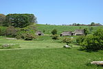
*Goryōkaku Site 五稜郭跡 Goryōkaku ato Hakodate
41°47′49″N 140°45′25″E / 41.79688684°N 140.75682682°E / 41.79688684; 140.75682682 (Goryōkaku Site ) 2
7
ウサクマイ遺跡群 Usakumai iseki-gun Chitose
42°49′06″N 141°34′31″E / 42.81837213°N 141.57521006°E / 42.81837213; 141.57521006 (Usakumai Sites ) 2
58
Otafunbe Chashi Siteオタフンベチャシ跡 Otafunbe chashi ato Urahoro
Ainu hilltop fort or chashi ota ) and "whale" (funbe )[6]
42°49′32″N 143°50′34″E / 42.82542292°N 143.8428036°E / 42.82542292; 143.8428036 (Otafunbe Chashi Site ) 2
61
Karinba ruins カリンバ遺跡 Karinba iseki Eniwa
42°53′19″N 141°35′41″E / 42.88870998°N 141.59483917°E / 42.88870998; 141.59483917 (Karinba Site ) 1
3413
キウス周堤墓群 Kiusu shūtei bogun Chitose
42°53′09″N 141°42′59″E / 42.88578385°N 141.71640587°E / 42.88578385; 141.71640587 (Kiusu Burial Mounds ) 1
60
Shibechari River Basin - Siteシベチャリ川流域チャシ跡群及びアッペツチャシ跡 Shibechari-gawa ryūiki chashi ato-gun oyobi Appetsu chashi ato Shinhidaka , Hidaka
42°19′46″N 142°22′21″E / 42.32935358°N 142.37250173°E / 42.32935358; 142.37250173 (Shibechari River Basin Chashi Sites - Appetsu Chashi Site ) 2
3204
ピリカ遺跡 Pirika iseki Imakane
42°28′36″N 140°12′17″E / 42.47658785°N 140.20462821°E / 42.47658785; 140.20462821 (Pirika Site ) 1
75
Fugoppe Cave フゴッペ洞窟 Fugoppe dōkutsu Yoichi
Zoku-Jōmon rock art : incised human figures, animals, and boats; excavated artefacts include earthenware and items made of stone, horn, and bone[7] [8] [9]
43°11′41″N 140°50′17″E / 43.19480151°N 140.83818127°E / 43.19480151; 140.83818127 (Fugoppe Cave ) 1
35
Yukuepira Chashi Siteユクエピラチャシ跡 Yukuepira chashi ato Rikubetsu
43°27′51″N 143°44′09″E / 43.46413265°N 143.73574912°E / 43.46413265; 143.73574912 (Yukuepira Chashi Site ) 2
70
音江環状列石 Otoe kanjō-resseki Fukagawa
43°40′27″N 142°02′00″E / 43.67411004°N 142.03334165°E / 43.67411004; 142.03334165 (Otoe Stone Circle ) 1
36
Former Hokkaidō Government Office 開拓使札幌本庁本庁舎跡および旧北海道庁本庁舎 Kaitakushi Sapporo honchō honchōsha ato oyobi kyū-Hokkaidō-chō honchōsha Sapporo
43°03′50″N 141°20′54″E / 43.06400008°N 141.34840509°E / 43.06400008; 141.34840509 (Former Hokkaidō Government Office ) 2
41
Kakinoshima Site 垣ノ島遺跡 Kakinoshima iseki Hakodate
41°55′44″N 140°56′51″E / 41.92881355°N 140.94750411°E / 41.92881355; 140.94750411 (Kakinoshima Site ) 1
00003697
旧奥行臼駅逓所 kyū-Okuyuki-eki teisho Betsukai
43°18′47″N 145°12′34″E / 43.31302103°N 145.20947525°E / 43.31302103; 145.20947525 (Former Okuyuki Station Facilities ) 6
00003717
旧下ヨイチ運上家 kyū-Shimo-Yoichi unjō-ke Yoichi
the ICP Matsumae Clan building of 1853 was renovated in 1891[10]
43°11′52″N 140°47′18″E / 43.19786188°N 140.78821805°E / 43.19786188; 140.78821805 (Former Lower Yoichi Duty House ) 6
47
Site 旧奥行臼駅逓所 kyū-Shimamatsu ekitei-sho Kitahiroshima
42°55′26″N 141°32′17″E / 42.92398022°N 141.53803619°E / 42.92398022; 141.53803619 (Former Shimamatsu Station ) 6
68
旧余市福原漁場 kyū-Yoichi Fukuhara gyoba Yoichi
herring fishing facilities
43°11′59″N 140°46′42″E / 43.19972159°N 140.778317°E / 43.19972159; 140.778317 (Former Yochi Fukuhara Fishery ) 6
63
旧留萌佐賀家漁場 kyū-Rumoi Saga-ke gyoba Rumoi
43°54′49″N 141°37′03″E / 43.91366758°N 141.61751178°E / 43.91366758; 141.61751178 (Former Rumoi Saga Family Fishery ) 6
77
琴似屯田兵村兵屋跡 Kotoni tondenhei-son heioku ato Sapporo
the tondenhei were former samurai recruited from 1874 as farmer-soldiers, to farm and potentially defend Hokkaidō[11]
43°54′49″N 141°37′03″E / 43.91366758°N 141.61751178°E / 43.91366758; 141.61751178 (Kotoni Tondenhei Residence ) 2,6
64
Katsuragaoka Chashi Site桂ヶ岡砦跡 Katsuragaoka chashi ato Abashiri
44°01′04″N 144°16′12″E / 44.01789442°N 144.26997445°E / 44.01789442; 144.26997445 (Katsuragaoka Chashi Site ) 1,2
20
Ebetsu Kofun Cluster 江別古墳群 Ebetsu kofun-gun Ebetsu
43°07′01″N 141°30′57″E / 43.11687899°N 141.51587387°E / 43.11687899; 141.51587387 (Ebetsu Kofun Cluster ) 1
3205
Site 国泰寺 跡Kokutaiji ato Akkeshi
43°01′50″N 144°50′15″E / 43.03062071°N 144.83746036°E / 43.03062071; 144.83746036 (Kokutaiji Site ) 3
48
Nemuro Peninsula Chashi Sites 根室半島チャシ跡群 Nemuro hantō chashi ato-gun Nemuro
43°10′14″N 145°30′24″E / 43.170601°N 145.50654468°E / 43.170601; 145.50654468 (Nemuro Peninsula Chashi Sites ) 2
66
最寄貝塚 Moyoro kaizuka Abashiri
44°01′31″N 144°16′05″E / 44.0251911°N 144.26806929°E / 44.0251911; 144.26806929 (Moyoro Shell Mound ) 1
22
Shiryōkaku 四稜郭 Shiryōkaku Hakodate
41°49′33″N 140°46′13″E / 41.82570421°N 140.77036763°E / 41.82570421; 140.77036763 (Shiryōkaku ) 2
14
Shinori Fortified Residence Site志苔館 跡Shinori tate ato Hakodate
destroyed in the Ainu uprisings of 1457 (Koshamain's War ) and 1512[12]
41°45′56″N 140°49′20″E / 41.76564477°N 140.82228894°E / 41.76564477; 140.82228894 (Shinoritate Fortified Residence Site ) 2
16
Temiya Cave 手宮洞窟 Temiya dōkutsu Otaru
incised rock art site published by John Milne in the Transactions of the Asiatic Society of Japan [9]
43°12′45″N 141°00′13″E / 43.21250491°N 141.00347991°E / 43.21250491; 141.00347991 (Temiya Cave ) 1
1
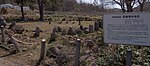
春採台地竪穴群 Harutoridaichi tateana-gun Kushiro
42°58′29″N 144°23′58″E / 42.9746889°N 144.39934378°E / 42.9746889; 144.39934378 (Harutoridaichi Pit Dwellings ) 1
21
Shōnai Han Hamamasu Site庄内藩ハママシケ陣屋跡 Shōnai-han Hamamashike jinya ato Ishikari
43°35′24″N 141°23′36″E / 43.59010579°N 141.39327093°E / 43.59010579; 141.39327093 (Shōnai Han Hamamasu Jin'ya Site ) 2
73
Matsumae Clan 松前氏城跡 Matsumae-shi shiro ato Matsumae , Assabu
designation includes the sites of Matsumae Castle (福山城跡 ) and (館城 跡
41°25′48″N 140°06′29″E / 41.43008755°N 140.1079181°E / 41.43008755; 140.1079181 (Matsumae Clan Castle Sites ) 2
17
Matsumae Han Site松前藩戸切地陣屋 跡 Matsumae-han Hekirichi jinya ato Hokuto
41°51′14″N 140°37′09″E / 41.85388046°N 140.61915976°E / 41.85388046; 140.61915976 (Matsumae Han Hekirichi Jin'ya Site ) 2
38
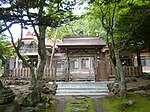
松前藩主松前家墓所 Matsumae-han-shu Matsumae-ke bosho Matsumae
41°25′53″N 140°06′21″E / 41.43127597°N 140.10592222°E / 41.43127597; 140.10592222 (Matsumae Han Matsumae Clan Graves ) 7
62
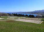
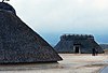
上之国館跡 Kaminokuni tate ato Kaminokuni
designation includes the sites of the Hanazawa (花沢館 跡 , Suzagi (洲崎館跡 ) , and Katsuyama (勝山館 跡 (pictured ) fortified residences
41°48′00″N 140°06′02″E / 41.8001294°N 140.10061858°E / 41.8001294; 140.10061858 (Kaminokuni Fortified Residence Sites ) 2
54
常呂遺跡 Tokoro iseki Kitami
44°07′48″N 144°00′56″E / 44.12991699°N 144.01562941°E / 44.12991699; 144.01562941 (Tokoro Site ) 1
49
西月ヶ岡遺跡 Nishitsukigaoka iseki Nemuro
43°18′59″N 145°33′31″E / 43.31649942°N 145.5586636°E / 43.31649942; 145.5586636 (Nishitsukigaoka Site ) 1
52
静川遺跡 Shizugawa iseki Tomakomai
42°40′37″N 141°49′06″E / 42.6770498°N 141.8184439°E / 42.6770498; 141.8184439 (Shizugawa Site ) 1
69
Site 善光寺 跡Zenkōji ato Date
42°31′15″N 140°46′48″E / 42.52080711°N 140.77993451°E / 42.52080711; 140.77993451 (Zenkōji Site ) 3
50
Site 大館跡 Ō tate ato Matsumae
41°26′10″N 140°06′32″E / 41.43601967°N 140.10886886°E / 41.43601967; 140.10886886 (Ō Fortified Residence Site ) 2
53
Ōfune Site 大船遺跡 Ōfune iseki Hakodate
submitted for inscription on the UNESCO World Heritage List as one of the Jōmon Archaeological Sites in Hokkaidō, Northern Tōhoku, and other regions [13] [14]
41°57′29″N 140°55′27″E / 41.95794955°N 140.9243044°E / 41.95794955; 140.9243044 (Ōfune Site ) 1
3300
大谷地貝塚 Ōyachi kaizuka Yoichi
43°11′27″N 140°50′07″E / 43.19088619°N 140.83530442°E / 43.19088619; 140.83530442 (Ōyachi Shell Mound ) 1
3270
East Ezo Nanbu Han Sites 東蝦夷地南部藩陣屋 跡 higashi Ezo-chi Nanbu-han jinya ato Muroran , Oshamambe , Mori
designation includes the sites of the Mororan Jin'ya (モロラン陣屋跡 ) , Oshamanbe Jin'ya (ヲシャマンベ陣屋跡 ) , and Sunahara Jin'ya (砂原陣屋跡 )
42°22′11″N 140°56′53″E / 42.36970568°N 140.94814432°E / 42.36970568; 140.94814432 (East Ezo Nanbu Han Jin'ya Sites ) 2
15
東釧路貝塚 higashi Kushiro kaizuka Kushiro
42°59′39″N 144°24′45″E / 42.99405818°N 144.41248976°E / 42.99405818; 144.41248976 (East Kushiro Shell Mound ) 1
42
入江・高砂貝塚 Irie-Takasago kaizuka Tōyako
submitted for inscription on the UNESCO World Heritage List as one of the Jōmon Archaeological Sites in Hokkaidō, Northern Tōhoku, and other regions [13] [14]
42°32′50″N 140°46′13″E / 42.54710056°N 140.77019889°E / 42.54710056; 140.77019889 (Irie-Takasago Shell Mound ) 1
3333
忍路環状列石 Oshoro kanjō-resseki Otaru
43°11′58″N 140°52′29″E / 43.199579°N 140.87464787°E / 43.199579; 140.87464787 (Oshoro Stone Circle ) 1
37
白滝遺跡群 Shirataki iseki Engaru
43°52′28″N 143°08′00″E / 43.8743758°N 143.13345593°E / 43.8743758; 143.13345593 (Shirataki Site ) 1
74
Shiraoi Sendai Han Site白老仙台藩陣屋跡 Shiraoi Sendai-han jinya ato Shiraoi
42°33′47″N 141°20′34″E / 42.56317149°N 141.34291527°E / 42.56317149; 141.34291527 (Shiraoi Sendai Han Jin'ya Site ) 2
39
標津遺跡群 Shibetsu iseki-gun Shibetsu
designation includes the Ichanikarikariusu Site (伊茶仁カリカリウス遺跡 ) , old road, and Sanbongi Site (三本木遺跡 )
43°40′28″N 145°05′39″E / 43.67438382°N 145.0941493°E / 43.67438382; 145.0941493 (Shibetsu Sites ) 1
51
北黄金貝塚 Kitakogane kaizuka Date
submitted for inscription on the UNESCO World Heritage List as one of the Jōmon Archaeological Sites in Hokkaidō, Northern Tōhoku, and other regions [13] [14]
42°24′07″N 140°54′38″E / 42.40203392°N 140.91064837°E / 42.40203392; 140.91064837 (Kitakogane Shell Mound ) 1
71
北斗遺跡 Hokuto iseki Kushiro
43°04′07″N 144°19′02″E / 43.06873613°N 144.31718424°E / 43.06873613; 144.31718424 (Hokuto Site ) 1
56
Site 茂別館跡 Mobetsu tate ato Hokuto
41°46′13″N 140°36′15″E / 41.77022042°N 140.60413071°E / 41.77022042; 140.60413071 (Mobetsu Fortified Residence Site ) 2
65
鷲ノ木遺跡 Washinoki iseki Mori
submitted for inscription on the UNESCO World Heritage List as one of the Jōmon Archaeological Sites in Hokkaidō, Northern Tōhoku, and other regions [13] [14]
42°06′58″N 140°31′34″E / 42.11602639°N 140.52606523°E / 42.11602639; 140.52606523 (Washinoki Site ) 1
00003466
チャシコツ岬上遺跡 Chashikotsu-misaki kami-iseki Shari 44°04′05″N 144°58′39″E / 44.068103°N 144.977435°E / 44.068103; 144.977435 (Cape Chashikotsu Upper Site ) [1]
様似山道 Samani sandō Samani [2]
猿留山道 Saruru sandō Erimo [3]
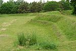
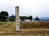
Kushiro River Basin 釧路川流域チャシ跡群 Kushiro-gawa-ryūiki chashi ato Kushiro designation comprises the sites of Moshiriya Chashi (モシリヤ砦 跡 (pictured ) and (鶴ヶ岱チャランケ砦跡 )
42°59′01″N 144°23′46″E / 42.98359641°N 144.39600128°E / 42.98359641; 144.39600128 (Kushiro River Basin Chashi Sites ) [4]
旧歌棄佐藤家漁場 kyū-Utasutsu Satō-ke gyoba Suttsu 42°47′24″N 140°18′36″E / 42.789952°N 140.309956°E / 42.789952; 140.309956 (Former Utasutsu Satō Family Fishery ) [5]