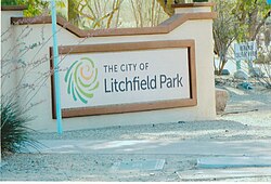
Litchfield Park, Arizona
Litchfield Park | |
|---|---|
City | |
 Welcome to Litchfield Park | |
 Seal | |
 Location of Litchfield Park in Maricopa County, Arizona. | |
 Litchfield Park Location in the United States | |
| Coordinates: 33°29′36″N 112°21′30″W / 33.49333°N 112.35833°WCoordinates: 33°29′36″N 112°21′30″W / 33.49333°N 112.35833°W | |
| Country | United States |
| State | Arizona |
| County | Maricopa |
| Government | |
| • Mayor | |
| Area | |
| • Total | 3.31 sq mi (8.58 km2) |
| • Land | 3.28 sq mi (8.50 km2) |
| • Water | 0.03 sq mi (0.08 km2) |
| Elevation | 1,030 ft (314 m) |
| Population | |
| • Total | 5,476 |
| • Estimate (2019)[1] | 6,436 |
| • Density | 1,961.60/sq mi (757.33/km2) |
| Time zone | UTC-7 (MST (no DST)) |
| ZIP code | 85340 |
| Area code(s) | 623 |
| FIPS code | 04-41330 |
| GNIS feature ID | 7058 |
| Website | http://www.litchfield-park.org/ |

Litchfield Park is a city in Maricopa County, Arizona, United States. It is located 20 miles (32 km) west of Phoenix. According to the U.S. Census, the population of the city was 5,476 as of 2010.[2]
History[]

The town of Litchfield Park is a historically affluent community outside of Phoenix named after its founder, Paul Weeks Litchfield (1875–1959). He was an executive of the Goodyear Tire & Rubber Company who came to the Phoenix area in 1916 in search of suitable land to farm a long-staple cotton that had previously been available only from the Sea Islands off the coast of Georgia and from Egypt. This cotton was needed to strengthen the rubber in the pneumatic tire, of which Goodyear was the world's largest producer. The East Coast cotton supply had been devastated by the boll weevil and the African supply had been greatly reduced by World War I attacks from German U-boats. Litchfield went to the Phoenix area at the suggestion of the USDA, but was not successful in motivating local farmers to grow his cotton. Instead, he got Goodyear to form the Southwest Cotton Company in Phoenix, with Litchfield as its president, eventually purchasing some 36,000 acres in the general Salt River Valley area, including 5,000 acres around the present site of Litchfield Park, then known as Litchfield Ranch. Much of the land was bought for as little as $25 per acre. The cotton was cultivated with a workforce of mostly Mexican and Native American men. The U.S. Postal Service agreed to the name "Litchfield Park" in 1926. In 1929, the Wigwam Resort was opened to the public. In 1926, Litchfield went on to become the president of the Goodyear-Zeppelin Corporation,[4] and then chairman of the board in 1930. He retired from the company in 1958, and spent the final months of his life as a resident of Litchfield Park at his home on Fairway Drive.[5]
In 1964, Goodyear created Litchfield Park Land and Development Co. to expand Litchfield Park into a 90,000-resident community.[6][7] Arden E. Goodyear was the head of the company, Patrick Cusick was vice president and general manager, and Victor Gruen was hired to design some of the buildings. Emanuel Cartsonis, who had worked with Cusick, became city planner. The plan called for 25,000 homes, a college, a junior college, eighteen elementary schools, ten junior high schools, and six high schools, as well as improvements to the town's golf course and Phoenix Trotting Park at an expense of at least $750 million.[8] Goodyear made many mistakes during development, including selling properties right up to the curb line, which means that the city must get permission from property owners before they can put in a sidewalk. They abandoned their plans for expanding Litchfield Park before they were completed and sold whatever land they could.[9]
Geography[]
Litchfield Park is located at 33°29′36″N 112°21′30″W / 33.49333°N 112.35833°W (33.493410, −112.358210).[10]
According to the United States Census Bureau, the city has a total area of 3.1 square miles (8.0 km2), all land with the exception of a man made lake.
Demographics[]
| Historical population | |||
|---|---|---|---|
| Census | Pop. | %± | |
| 1970 | 1,664 | — | |
| 1980 | 3,657 | 119.8% | |
| 1990 | 3,303 | −9.7% | |
| 2000 | 3,810 | 15.3% | |
| 2010 | 5,476 | 43.7% | |
| 2019 (est.) | 6,436 | [1] | 17.5% |
| U.S. Decennial Census[11] | |||
Litchfield Park had a population of 5,476 at the 2010 census. The racial and ethnic composition of the population was 74.3% non-Hispanic white, 3.5% black or African American, 1.0% Native American, 4.1% Asian, 0.1% non-Hispanic from some other race, 2.8% two or more races and 15.4% Hispanic or Latino.[12]
Government[]
The mayor is , the vice mayor is . The city council members are: Ann Donahue, Ron Clair, John Romack, Tom Rosztoczy, and Lisa Brainard Watson.[13] The first mayor was .
Education[]
[14] The Litchfield Elementary School District and the Agua Fria Union High School District serve Litchfield Park. Litchfield Elementary School District has some schools located in the city.
Historic structures[]
| Part of a series of the |
| Cities, towns and CDPs in Arizona with lists and images of historic properties, forts, cemeteries or historic districts |
|---|
Pictured are the following structures:
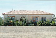
- Two of the original Litchfield Elementary School buildings – both date back to 1918 and are located at 13825 W Wigwam Blvd.[15]

- The Litchfield Train Station – built in 1920, near Maricopa County 85 and Litchfield Road. It was a feeder station of the Southern-Pacific Rock-Island Line. In 2009, the City of Goodyear purchased the station for $5,000. The station was moved to city owned land by Maricopa County 85 and Estrella Parkway where it currently lies in a total state of abandonment and deterioration.[16]
- St. Thomas Mission Church a.k.a. "St. Thomas Aquinas Mission Church" – built in 1919 and located in Wigwam Road. The church which was built primarily for the Mexican farm workers of the Southwest Cotton Company. Cardinal Francis Spellman once celebrated Mass in this mission church. In 1969, the Church became part of the Phoenix Diocese.[17]
- The Church at Litchfield Park – built in 1938 and located at 300 East Wigwam Boulevard.[18]
- The Wigwam Organizational House, was originally built by The Goodyear Tire & Rubber Company in 1918, as lodging for local ranch suppliers. This was the first building of what was to become the Wigwam Hotel.[19]
- The Wigwam Hotel – officially opened its doors to the public in 1929. The hotel came about as a result of an expansion of the 1918, Wigwam Organizational House. The hotel is located at 300 East Wigwam Boulevard. The Wigwam Hotel, is a member of the Historic Hotels of America since 2010. Among the celebrities which have stayed in the hotel are Britney Spears, Clint Eastwood, Chuck Norris and Billy Joel.[20][21]
- Aunt Mary's House – built in 1941 and located at 13912 West Camelback Road on the northwest corner of Camelback and Litchfield Roads. Mary Brintan-Tubbs was active in the Litchfield Park Community. During World War II she volunteered and worked at the Luke Air Force Base, rolling bandages, writing letters for soldiers, doing other necessary civilian tasks. Aunt Mary's House (as it is affectionately called), now is home to the Litchfield Park Historical Society and Museum.[22]
Historic structures pictured[]
The following are the images of the historic structures in Litchfield Park and its surrounding areas:


One of two original Litchfield Elementary Schools.

The second original Litchfield Elementary School buildings.
Litchfield Train Station.

St Thomas Mission Church cornerstone.

St Thomas Mission Church built in 1919.
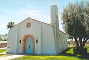
Different view of the St Thomas Mission Church.
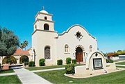
The Church at Litchfield Park built in 1938

Different view of The Church at Litchfield Park.

The original Organizational House built in 1918.

Wigwam Hotel entrance.

The Wigwam Hotel opened its doors in 1929.
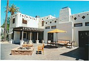
Different view of the Wigwam Hotel.

The lobby inside the Wigwam Hotel.
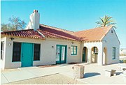
Aunt Mary's House.

Different view of Aunt Mary's House.


Tourism[]

- Kiwanis Litchfield Park Winter Trout Fishing Derby
- Annual Wigwam Festival of Fine Art
- Arts in the Park Concert Series
- Flavors of the West Festival
- Litchfield Park Friends of the Rec 10k, 5k, 1 Mile Run/Walk
- Annual Spring Art & Culinary Festival
- Memorial Day Ceremony
- "Splash Bash"
- Independence Day Fireworks Celebration
Notable people[]
- Ray King, former MLB relief pitcher
- Jacque Mercer, former Miss America
See also[]
- Goodyear Farms Historic Cemetery a.k.a. "Litchfield Cemetery"
References[]
- ^ Jump up to: a b "Population and Housing Unit Estimates". Retrieved May 21, 2020.
- ^ Jump up to: a b "U.S. Census website". United States Census Bureau. Retrieved June 18, 2014.
- ^ "2019 U.S. Gazetteer Files". United States Census Bureau. Retrieved June 30, 2020.
- ^ TIME Magazine Cover Story
- ^ A History of Litchfield Park Archived April 1, 2012, at the Wayback Machine
- ^ "Rubber Firm Hiring Cusick". The Pittsburgh Press. June 25, 1964. Retrieved June 20, 2012.
- ^ "Planner Here Going West". The Pittsburgh Press. June 24, 1964. Retrieved June 20, 2012.
- ^ "22 Miles Of Arizona Luring Cusick From Planning Job Here". The Pittsburgh Press. August 16, 1964. Retrieved June 20, 2012.
- ^ Madrid, David (April 27, 2012). "Decline of Scout Park angers Litchfield Park neighbor". The Republic. Retrieved June 20, 2012.
- ^ "US Gazetteer files: 2010, 2000, and 1990". United States Census Bureau. February 12, 2011. Retrieved April 23, 2011.
- ^ "Census of Population and Housing". Census.gov. Retrieved June 4, 2016.
- ^ 2010 census chart for Litchfield Park
- ^ "Official Web Site of the City of Litchfield Park". Litchfield Park, AZ. Retrieved November 24, 2019.
- ^ http://www.litchfield-park.org/index.aspx?NID=722
- ^ Litchfield History
- ^ Home Depot
- ^ St. Thomas Aquinas Church
- ^ Church at Litchfield Park
- ^ hotels.org/hotels-resorts/the-wigwam/ Historic Hotels of America
- ^ 20 cities in 20 Days: Wigwam Resort's history with celebrities
- ^ Wigwam Arizona
- ^ Aunt mary's House
External links[]
| show Municipalities and communities of Maricopa County, Arizona, United States |
|---|

| show Authority control |
|---|
- Cities in Arizona
- Cities in Maricopa County, Arizona
- Populated places established in 1987
- Populated places in the Sonoran Desert
- Phoenix metropolitan area
- 1987 establishments in Arizona