Cave Creek, Arizona
Cave Creek, Arizona | |
|---|---|
 Welcome to Cave Creek Marker | |
 Seal | |
 Location of Cave Creek in Maricopa County, Arizona | |
 Cave Creek, Arizona Location in the United States | |
| Coordinates: 33°50′00″N 111°57′03″W / 33.83333°N 111.95083°WCoordinates: 33°50′00″N 111°57′03″W / 33.83333°N 111.95083°W | |
| Country | United States |
| State | Arizona |
| County | Maricopa |
| Government | |
| • Mayor | Ernie Bunch |
| Area | |
| • Total | 37.72 sq mi (97.68 km2) |
| • Land | 37.71 sq mi (97.66 km2) |
| • Water | 0.01 sq mi (0.02 km2) |
| Elevation | 2,126 ft (648 m) |
| Population | |
| • Total | 5,015 |
| • Estimate (2019)[1] | 5,838 |
| • Density | 154.82/sq mi (59.78/km2) |
| Time zone | UTC-7 (MST (no DST)) |
| ZIP codes | 85327, 85331 |
| Area code(s) | 480 |
| FIPS code | 04-11300 |
| GNIS feature ID | 24771[3] |
| Website | Official website |


Cave Creek is a town in Maricopa County, Arizona, United States. The largest city it borders is Phoenix.[5] According to the 2010 census, the population of the town was 5,015.
History[]
Cave Creek was settled in 1870 by soldiers on horseback from Fort McDowell. In 1873, prospectors from the Bradshaw Mountains found gold in the town. The town is named for the cave next to the creek the town was founded on.[6][7]
Geography[]
Cave Creek is a town in the Sonoran Desert.
According to the United States Census Bureau, the town has a total area of 28.2 square miles (73 km2), all land. It is adjacent to the town of Carefree, and shares local landmark Black Mountain with Carefree.
There are two notable streams known as Cave Creek in Arizona. One flows through the Town of Cave Creek and into Phoenix. This may be the origin of the town's name. The other Cave Creek (Cave Creek Canyon) is in the Chiricahua Mountains, 200 miles to the southeast.
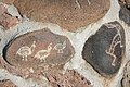
In 2000, the state of Arizona, Maricopa County, and the town of Cave Creek bought Spur Cross Ranch, a 2,154-acre (8.72 km2) tract of Sonoran desert just north of Phoenix, for $21 million. It had unusual cacti, stone formations, and hundreds of pre-history Hohokam Indian tribal artifacts, and is now a Maricopa County park.[8]
Climate[]
The hot season lasts for 6 months, from May 31 to September 19, with an average daily high temperature above 110 °F. The hottest day of the year is July 3, with an average high of 115 °F and low of 93 °F.
The cool season lasts for 3.4 months, from November 20 to March 1, with an average daily high temperature below 69 °F. The coldest day of the year is December 27, with an average low of 41 °F and high of 61 °F.[9]
Demographics[]
| Historical population | |||
|---|---|---|---|
| Census | Pop. | %± | |
| 1980 | 1,712 | — | |
| 1990 | 2,925 | 70.9% | |
| 2000 | 3,728 | 27.5% | |
| 2010 | 5,015 | 34.5% | |
| 2019 (est.) | 5,838 | [1] | 16.4% |
| U.S. Decennial Census[10] | |||
As of the census of 2000, there were 3,728 people, 1,571 households, and 1,101 families residing in the town. The population density was 132.0 people per square mile (51.0/km2). There were 1,753 housing units at an average density of 62.1 per square mile (24.0/km2). The racial makeup of the town was 95.0% White, <0.1% Black or African American, 0.2% Native American, 0.4% Asian, 0.1% Pacific Islander, 2.6% from other races, and 1.5% from two or more races. Hispanic or Latino of any race were 7.0% of the population.
Out of the 1,571 households some 27.1% had children under the age of 18 living with them, 59.0% were married couples living together, 7.4% had a female householder with no husband present, and 29.9% were non-families. 24.3% of all households were made up of individuals, and 6.2% had someone living alone who was 65 years of age or older. The average household size was 2.37 and the average family size was 2.80.
In the town, the population was spread out, with 20.9% under the age of 18, 5.5% from 18 to 24, 24.2% from 25 to 44, 36.1% from 45 to 64, and 13.3% who were 65 years of age or older. The median age was 45 years. For every 100 females, there were 100.1 males. For every 100 females age 18 and over, there were 97.5 males.
The median income for a household in the town was $59,938, and the median income for a family was $76,549. Males had a median income of $50,399 versus $31,607 for females. The per capita income for the town was $38,070. About 6.0% of families and 7.7% of the population were below the poverty line, including 12.9% of those under age 18 and 7.3% of those age 65 or over.
Arts and culture[]
Historic properties located at the Cave Creek Museum include the Tubercular Cabin (listed on the National Register of Historic Places (NRHP)), the First Church of Cave Creek, and Golden Reef Stamp Mill. Two historic properties have been converted into restaurants: the Cave Creek Inn, and the Cave Creek Service Station (listed on NRHP). Another location, Frontier Town, has some of Cave Creek's original structures.[11][12][13]
Government[]
In June 2009, Cave Creek attracted media attention when a game of chance was used to break a tie in a vote for Town Council. The drawing of playing cards led to the victory of 25-year-old law student Adam Trenk[14] over incumbent Town Council member Thomas McGuire. The Arizona State Constitution allows a game of chance to be used to break ties.[15]
"Where the Wild West Lives" was adopted as the town motto by the Cave Creek Town Council during a November 2013 meeting.[16]
Education[]
The portion of Cave Creek west of longitude 111°59'44.21"W is served by Deer Valley Unified School District and the remainder of the town by Cave Creek Unified School District.
Infrastructure[]
Transportation[]
Cave Creek residents use Phoenix Sky Harbor International Airport or Mesa Gateway Airport to fly on commercial airlines.[citation needed] Deer Valley Airport, the closest airport to Cave Creek, is a very active general aviation airport.
Notable people[]
- Kiowa Gordon, actor
- Stephenie Meyer, author[17]
- David Henrie, actor
- Brian Dales, singer of The Summer Set
- Sonny Barger, founder of the Oakland chapter of the Hells Angels
- Earl Simmons, rapper, actor, popularly known as DMX
- Taylor Lewan, NFL player for Tennessee Titans, drafted in 2014
- Shane Doan, NHL player for the Arizona Coyotes[18]
- Dee Dee Wood, Emmy Award winning choreographer
Gallery[]
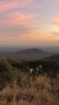
Black Mountain seen from North Scottsdale

Spring flowers, 2019

Quarry opening at Cave Creek, 1893
Cave Creek Recreational Park
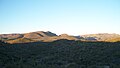
Trail markers at Spur Cross Park, north of Cave Creek


See also[]
- List of towns in Arizona
- Cave Creek Complex fire
- List of historic properties in Cave Creek, Arizona
References[]
- ^ Jump up to: a b "Population and Housing Unit Estimates". Retrieved May 21, 2020.
- ^ "U.S. Census website". United States Census Bureau. Retrieved June 18, 2012.
- ^ U.S. Geological Survey Geographic Names Information System: Cave Creek
- ^ "2019 U.S. Gazetteer Files". United States Census Bureau. Retrieved June 30, 2020.
- ^ https://www.arizona-leisure.com/gfx/maps/valley-sun-map-760.gif
- ^ https://cavecreekmuseum.org/the-history-of-cave-creek/
- ^ https://www.dflt.org/a-short-history-of-cave-creek
- ^ Greg Gordon (October 27, 2008). "McCain pushed regulators for land swap, despite pledge". McClatchy Newspapers. Archived from the original on October 30, 2008. Retrieved October 28, 2008.
- ^ https://weatherspark.com/y/2603/Average-Weather-in-Cave-Creek-Arizona-United-States-Year-Round
- ^ "Census of Population and Housing". Census.gov. Retrieved June 4, 2016.
- ^ Cave Creek Out Door Exhibits
- ^ National Register of Historic Places
- ^ Arizona Republic
- ^ https://www.roselawgroup.com/trenk-adam-m/
- ^ Archibold, Randal C. Election at a Draw, Arizona Town Cuts a Deck, The New York Times, June 16, 2009. Accessed 2009-08-25.
- ^ Carcamo, Cindy. (November 7, 2013). A showdown between Arizona towns over motto. The Los Angeles Times. Archived November 9, 2013, at the Wayback Machine
- ^ Arizona Republic
- ^ McLellan, Sarah (October 12, 2016). "Hockey, horses constants for Arizona Coyotes' Shane Doan". azcentral. The Arizona Republic. Retrieved October 13, 2016.
External links[]
| Wikimedia Commons has media related to Cave Creek, Arizona. |
| Wikivoyage has a travel guide for Cave Creek. |
- Official website
- "That Cave Creek Movie" (YouTube)
| show Municipalities and communities of Maricopa County, Arizona, United States |
|---|

| show Authority control |
|---|
- Towns in Maricopa County, Arizona
- Phoenix metropolitan area
- Populated places established in 1986