Goodyear, Arizona
Goodyear | |
|---|---|
City | |
 Goodyear City Hall building at 190 N Litchfield Road | |
|
Seal | |
 Location of Goodyear in Maricopa County, Arizona | |
 Goodyear Location within the state of Arizona | |
| Coordinates: 33°27′00″N 112°21′30″W / 33.45000°N 112.35833°WCoordinates: 33°27′00″N 112°21′30″W / 33.45000°N 112.35833°W | |
| Country | United States |
| State | Arizona |
| County | Maricopa |
| Government | |
| • Mayor | Georgia Lord |
| Area | |
| • Total | 191.33 sq mi (495.53 km2) |
| • Land | 191.30 sq mi (495.45 km2) |
| • Water | 0.03 sq mi (0.08 km2) |
| Elevation | 968 ft (295 m) |
| Population | |
| • Total | 65,275 |
| • Estimate (2019)[4] | 86,840 |
| • Density | 453.96/sq mi (175.27/km2) |
| Time zone | UTC-7 (MST (no DST)) |
| ZIP code | 85338, 85395 |
| Area code(s) | 623 |
| FIPS code | 04-28380 |
| GNIS feature ID | 5172[2] |
| Website | http://www.goodyearaz.gov/ |


Goodyear (O'odham: Valin Thak) is a city in Maricopa County, Arizona, United States. It is a suburb of Phoenix and at the 2010 census had a population of 65,275.[3] It was the third-fastest-growing city in Arizona between 1990 and 2000. The 2019 population estimate was 86,840.[5]
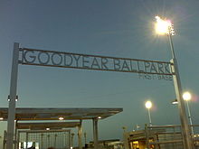
The city is home to the Goodyear Ballpark, where the Cleveland Indians and Cincinnati Reds of Major League Baseball hold spring training.
In 2008, Goodyear won the All-America City Award, sponsored by the National Civic League. The city is named after the Goodyear Tire and Rubber Company. The company cultivated extensive farmland here to grow cotton for use in its tires.
History[]
Goodyear was established in 1917 with the purchase of 16,000 acres (65 km2) of land by the Goodyear Tire and Rubber Company to cultivate cotton for vehicle tire cords. World War II was important to Goodyear in the 1940s as the current Phoenix Goodyear Airport was built, but after the war, the economy suffered. Goodyear became a town on November 19, 1946.[6] At the time, it had 151 homes and 250 apartments, a grocery store, a barber shop, beauty shop and a gas station.
World War II[]
Luke Field Auxiliary #6 (Goodyear Field) was built by the United States Army Air Forces in 1943. It served as a satellite airfield for Luke Army Air Field (AAF). According to the History of Luke AFB, this airfield boasted the most facilities. It had separate buildings for crew chiefs, operations, supply, barracks, pit latrine, crash truck shed, generator shed and a control tower. Luke AF Auxiliary #6 ceased operations by 1971.[7]
The property, which is in a state of complete abandonment, is owned by the State of Arizona, which has worked with developers on proposals for use.[7]
See the gallery of images below.
Modern history[]
In January 1965, the Phoenix Trotting Park, a harness racing track opened, the current Interstate 10 passes north of the site. As the region lacked major roads from Phoenix to Goodyear, there was not enough business and the track closed two years later. The Park no longer stands, as it was demolished in 2017. The park had been abandoned since the late 1960s.
The town became a city in 1985. In the same decade, the remaining 10,000 acres (40 km2) of the original farmland was sold for future development. The Phoenix Goodyear Airport received its current name in 1986.[8]
Housing and growth[]
Although Goodyear was founded in 1917, the majority of construction and population growth happened after 1990. 22 communities that are completed and under construction have a total area of approximately 20,000 acres (31 sq mi). These communities, along with another 21 communities for future suburban development, will contain almost 200,000 homes, with only 25,000 built.[9]
Goodyear was affected by the 2000s American housing bubble, reducing home values. Since then, the housing market has rebounded considerably. According to Opendoor, zip code 85338 in Goodyear was the fifth most popular place in the Phoenix metro area to buy a home, based on home sales. There are also a variety of home options in 2019 to accommodate families, those who are single, and seniors. As the population in Goodyear grows faster than ever, home builders and community developers are working quickly to keep up with the demand.
Estrella is the largest community in Goodyear, at 20,000 acres (31 sq mi). The community is home to about 10,000 residents. Palm Valley, located north of Interstate 10, is 9,000 acres (14 sq mi), with variously-sized homes. PebbleCreek is a community for active adult living, with 54 holes of championship golf, fitness centers, and restaurants.
From the 1990s through the 2010s, residential development has stimulated the growth of Goodyear as a suburb of Phoenix. Goodyear's population is projected to be 358,000 by 2035.[10]
Geography[]
Goodyear is approximately 17 miles (27 km) west of downtown Phoenix. Nearby cities include Avondale, Litchfield Park, Tolleson and Buckeye.
According to the United States Census Bureau, the city has a total area of 116.5 square miles (302 km2), all land. The Gila River passes through the city. The largest master-planned community is Estrella, south of the Gila River, located near the Estrella Mountains.[11]
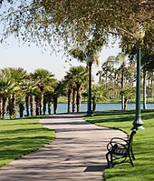
The Estrella Mountain Regional Park covers almost 20,000 acres (81 km2), most of which is still desert. It contains eight trails over 30 mi (48 km) in combined length, two baseball fields, and a 9.5-mile (15.3 km) track.[12]
| show Places adjacent to Goodyear, Arizona |
|---|
Climate[]
Goodyear has a hot desert climate (Köppen: BWh) due to its location in the Sonoran Desert. The city receives somewhere around ten inches of rain annually. The city has more than 300 sunny days per year.
Winters are sunny with mild temperatures—nighttime lows averaging between 40 °F and 50 °F (4 °C and 10 °C) and daytime highs ranging from 60 °F to 75 °F (16 °C to 24 °C). The lowest temperature ever recorded in Goodyear is 16 °F (-9 °C). Summers are very hot, with daily high temperatures at or above 100 °F (38 °C) for the entirety of June, July, and August, as well as many days in May and September. An occasional heat wave will spike temperatures over 115 °F (46 °C) briefly. Nighttime lows in the summer months average between 70 °F and 80 °F (21 °C and 27 °C), with an occasional overnight low above 80 °F (27 °C) not uncommon. The highest recorded temperature in Goodyear is 125 °F (52 °C).
Snow is rare in the area, occurring once every several years. Lows in the winter occasionally dip below freezing, which may damage some desert plants such as saguaros and other cacti. In the summer (mainly July, August and early September), the North American Monsoon can hit the Phoenix area in the afternoon and evening (possibly continuing overnight), causing thunderstorms and heavy rain even from a sunny morning. Dust storms are occasional, mainly during the summer.
| hideClimate data for Goodyear, Arizona | |||||||||||||
|---|---|---|---|---|---|---|---|---|---|---|---|---|---|
| Month | Jan | Feb | Mar | Apr | May | Jun | Jul | Aug | Sep | Oct | Nov | Dec | Year |
| Record high °F (°C) | 89 (32) |
93 (34) |
100 (38) |
105 (41) |
115 (46) |
125 (52) |
125 (52) |
120 (49) |
116 (47) |
109 (43) |
98 (37) |
89 (32) |
125 (52) |
| Average high °F (°C) | 65 (18) |
70 (21) |
76 (24) |
85 (29) |
94 (34) |
103 (39) |
105 (41) |
103 (39) |
98 (37) |
87 (31) |
74 (23) |
64 (18) |
85 (30) |
| Average low °F (°C) | 42 (6) |
45 (7) |
50 (10) |
56 (13) |
64 (18) |
72 (22) |
79 (26) |
79 (26) |
72 (22) |
59 (15) |
48 (9) |
41 (5) |
59 (15) |
| Record low °F (°C) | 16 (−9) |
22 (−6) |
22 (−6) |
27 (−3) |
36 (2) |
49 (9) |
57 (14) |
50 (10) |
44 (7) |
31 (−1) |
22 (−6) |
20 (−7) |
16 (−9) |
| Average precipitation inches (mm) | 0.99 (25) |
1.28 (33) |
0.97 (25) |
0.37 (9.4) |
0.11 (2.8) |
0.04 (1.0) |
0.83 (21) |
1.23 (31) |
0.95 (24) |
0.49 (12) |
0.68 (17) |
0.99 (25) |
8.93 (227) |
| Source: The Weather Channel[13] | |||||||||||||
Demographics[]
| Historical population | |||
|---|---|---|---|
| Census | Pop. | %± | |
| 1930 | 1,135 | — | |
| 1950 | 1,254 | — | |
| 1960 | 1,654 | 31.9% | |
| 1970 | 2,140 | 29.4% | |
| 1980 | 2,747 | 28.4% | |
| 1990 | 6,258 | 127.8% | |
| 2000 | 18,911 | 202.2% | |
| 2010 | 65,275 | 245.2% | |
| 2019 (est.) | 86,840 | [4] | 33.0% |
| U.S. Decennial Census[14] | |||
2010 Census[]
As of 2010, the U.S. Census Bureau reported that there were 65,275 people living in the city. 71.9% of the city's population was White, 6.7% were Black, 1.3% were Native American, and 4.3% were Asian. 27.8% were Hispanic or Latino of any race. There were 25,027 housing units in the city.[15] 31% of the population is between ages 35 and 49.
2000 Census[]
As of 2000, there were 18,911 people, 6,179 households, and 4,986 families living in the city. The population density was 162.4 people per square mile (62.7/km2). There were 6,771 housing units at an average density of 58.1 per square mile (22.4/km2). The racial makeup of the city was 78.13% White, 5.20% African American, 1.06% Native American, 1.71% Asian, 0.08% Pacific Islander, 10.87% from other races, and 2.95% from two or more races. 20.80% of the population were Hispanic or Latino of any race.
There were 6,179 households, out of which 32.7% had children under the age of 18 living with them, 71.1% were married couples living together, 6.4% had a female householder with no husband present, and 19.3% were non-families. 14.1% of all households were made up of individuals, and 3.7% had someone living alone who was 65 years of age or older. The average household size was 2.68 and the average family size was 2.94.
In the city, the population was spread out, with 22.2% under the age of 18, 8.7% from 18 to 24, 34.1% from 25 to 44, 25.1% from 45 to 64, and 9.9% who were 65 years of age or older. The median age was 36 years. For every 100 females, there were 103.7 males. For every 100 females age 18 and over, there were 102.5 males.
The median income for a household in the city was $57,492, and the median income for a family was $60,707. Males had a median income of $40,702 versus $28,410 for females. The per capita income for the city was $22,506. About 3.6% of families and 6.1% of the population were below the poverty line, including 8.7% of those under age 18 and 3.7% of those age 65 or over.
Government and infrastructure[]
Goodyear has a council-manager form of government. The current mayor is Georgia Lord, who was elected to fill a two-year unexpired term as Mayor of the City of Goodyear in March 2011, was re-elected to serve a second term as Mayor in 2013, and was elected to serve her final term in 2017. The mayor has a two-term limit. The vice mayor of the city is Wally Campbell, who was first elected in 2011. There are six councilmembers, with three-term limits.[16]
The Arizona Department of Corrections operates the Arizona State Prison Complex-Perryville in Goodyear.[17] The prison houses the female death row.[18]
Education[]
Several school districts serve the city of Goodyear. Elementary school districts include Avondale Elementary School District, Liberty Elementary School District, Litchfield Elementary School District, and Mobile Elementary School District. High school districts include Agua Fria Union High School District and Buckeye Union High School District.[19]
Elementary/middle schools[]
- Incito Schools
- Mabel Padgett Elementary School
- Palm Valley Elementary School
- Desert Star Elementary School
- Centerra Mirage S.T.E.M Academy
- Copper Trails Elementary School
- Desert Thunder Elementary School
- Estrella Mountain Elementary School k-8
- Westar Elementary School
- Western Sky Middle School
- Wildflower Elementary School
- Odyssey Preparatory Academy
- St. John Vianney Catholic School
High schools[]
- Desert Edge High School
- Millennium High School
- Estrella Foothills High School
Colleges and universities[]
Franklin Pierce University has had a campus here since 2008, when the New Hampshire-based university signed a lease with the city to purchase 30 acres (120,000 m2) of land.[23] It offers a Doctor of Physical Therapy program and other healthcare-related programs.[24]
Sports[]
Goodyear is known as a site for professional baseball teams' spring training sessions. The Cleveland Indians of Major League Baseball's American League moved their spring training facility to Goodyear from Winter Haven, Florida and rejoined the Cactus League in February 2009, after a 15-year absence. Before that, the Indians held spring training for many years in Tucson.
On April 7, 2008, Goodyear's city council unanimously approved a memorandum to fund a new $33 million baseball spring training complex for Major League Baseball's Cincinnati Reds and Cleveland Indians. This includes a 10,000-seat park, Goodyear Ballpark, that opened in 2009. The Reds and the Indians have separate offices, clubhouses and practice fields. The Indians had held their spring training in Tucson for many years until moving to Winter Haven in 1993. They agreed in 2006 to return their spring training location to Arizona at Goodyear.
The Goodyear Centennials, of the Freedom Pro Baseball League, played their home games at the Goodyear Ballpark. Two other baseball teams in the Arizona League, the Arizona League Indians and the Arizona League Reds, also play at the stadium.
Transportation[]
Air[]
Phoenix Goodyear Airport is located here. It has an 8,500 feet (2,600 m) runway capable of handling large jet aircraft. This airport, used by many international airlines for aircraft maintenance and storage, has no active commercial air service.
Rail[]
Union Pacific operates a railroad that goes through Goodyear. Rail lines provide Goodyear with access to 23 states in the western two-thirds of the United States.
Road transport[]
Interstate 10 passes through Goodyear, heading west to Buckeye and Los Angeles. I-10 heads east to Phoenix, Tucson, and the Southern states.
The city is also served by the western ends of several bus routes of the Valley Metro Bus.[25]
Other roads and highways serve the area. Loop 303 starts as Cotton Lane then heads up north to Surprise and then to Interstate 17. Van Buren Street, McDowell, Indian School and Camelback Roads are major arterial roads leading from the extreme western Phoenix area to past Scottsdale, in the east. MC 85 (Maricopa County Highway 85) is a highway running from Arizona State Route 85 in Buckeye to Loop 202 in Phoenix. The highway passes the southern sections of Goodyear.
Road improvements[]
Interstate 10 was built through Goodyear in the late 20th century. Between 2008 and 2014, the road had significant expansions. It was expanded from 2 lanes in each direction to 5 or 6 (including one HOV lane starting near Loop 303 going east). There were also new interchanges, including Exit 122 (Perryville Road), Exit 123 (Citrus Road) and Exit 125 (Sarival Avenue).
Loop 303 improvement[]
The Arizona Department of Transportation built a new interchange near the Interstate 10/Loop 303 junctions. The interchange is being expanded from a diamond interchange to a stack interchange. As a result, Loop 303 under Interstate 10 was cleared, and Exit 124 on Interstate 10 has been shut down; the new interchange was completed in 2014.
South of Interstate 10, Loop 303 is being planned to extend to a future State Route 30. Loop 303 will go South of future State Route 30 to Estrella Mountain Ranch & to Interstate 8 near Mobile, Arizona.[26]
State Route 30 (formerly State Route 801)[]
Arizona State Route 30 (originally designated as State Route 801) is a proposed highway south of Interstate 10 that will relieve traffic congestion. It is planned to run between Arizona State Route 85 to Interstate 17.[27]
Galleries[]
This gallery includes photos of the following:
- The Litchfield Train Station - built in 1920 to serve the town of Litchfield Park and sold to the City of Goodyear for $5,000 in 2009. The station, which once was located near Maricopa County 85 and Litchfield Road, was moved to the city waterworks land, where it currently lies in a total state of abandonment and deterioration.[28]
- Phoenix Trotting Park, a horse racing track built in 1964. It opened in 1965 and was run for about two and a half seasons. The property sat abandoned since its closure and was demolished in 2017.[29]
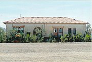
- A Goodyear-Wingfoot house - located in Greenleaf Lane in the town of Goodyear, was built by a Southwest Cotton factory at Litchfield Airport in 1943. Called the "home of the future," the Wingfoot Houses were 8 feet wide. Once on site, the bedroom wings were pulled out like drawers to yield a "T"-shaped, flat-roofed house. It had 255 square feet (23.7 m2) of living area.[30][31]
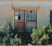
Litchfield Train Station.

Front of the Phoenix Trotting Park, built in 1965, closed in 1966.
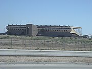
A different view of the front of the Phoenix Trotting Park.

Another view of the Phoenix Trotting Park.
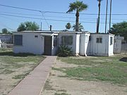
AWingfoot House

The Phoenix-Goodyear Airport "bone-yard" where planes that are no longer in use are kept.


Lake Field gallery[]

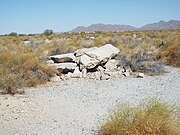
Landing Strip L288 with its original markings

Different view of the landing Strip L288 with its original markings.
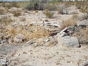
USAAF building ruins.
More USAAF building ruins.
Luke Field Auxiliary #6 landing strip.


Notable people[]
- Mitchell Watt, former Buffalo Bulls basketball player from Desert Edge High School
- Carrick Felix, former Arizona State Sun Devils men's basketball and current Cleveland Cavaliers player
- Rick Manning, former MLB player and current baseball broadcaster
References[]
- ^ "2019 U.S. Gazetteer Files". United States Census Bureau. Retrieved June 30, 2020.
- ^ Jump up to: a b U.S. Geological Survey Geographic Names Information System: Goodyear, Arizona
- ^ Jump up to: a b "U.S. Census website". United States Census Bureau. Retrieved June 18, 2014.
- ^ Jump up to: a b "Population and Housing Unit Estimates". United States Census Bureau. May 24, 2020. Retrieved May 27, 2020.
- ^ "U.S. Census website". United States Census Bureau. Retrieved January 31, 2019.
- ^ "Goodyear, AZ – Official Website – Goodyear at a Glance". Archived from the original on September 23, 2012. Retrieved December 18, 2012.
- ^ Jump up to: a b Airfields
- ^ "Goodyear, AZ – Official Website – History". Archived from the original on May 29, 2013. Retrieved December 17, 2012.
- ^ "Goodyear, AZ – Official Website – Housing". Archived from the original on March 11, 2013. Retrieved December 18, 2012.
- ^ "Goodyear, AZ – Official Website – Demographics and Growth". Archived from the original on September 24, 2012. Retrieved December 18, 2012.
- ^ "Archived copy". Archived from the original on July 4, 2008. Retrieved August 7, 2008.CS1 maint: archived copy as title (link)
- ^ "Goodyear, AZ – Official Website – Attractions – Goodyear Area". Archived from the original on May 31, 2013. Retrieved December 18, 2012.
- ^ "Monthly Averages for Goodyear, AZ". Weather.com. 2018. Retrieved May 17, 2018.
- ^ "Census of Population and Housing". Census.gov. Retrieved June 4, 2016.
- ^ "Goodyear city, Arizona QuickLinks from the US Census Bureau". Archived from the original on June 12, 2013. Retrieved December 18, 2012.
- ^ "Goodyear, AZ – Official Website – Mayor and Council". Archived from the original on May 29, 2013. Retrieved December 17, 2012.
- ^ "Arizona State Prison Complex- Perryville." Arizona Department of Corrections. Retrieved on August 16, 2010.
- ^ "Death Row Information and Frequently Asked Questions Archived May 27, 2010, at the Wayback Machine." Arizona Department of Corrections. Retrieved on August 16, 2010.
- ^ "Schools & Education Archived December 17, 2007, at the Wayback Machine." City of Goodyear. Retrieved on March 24, 2009.
- ^ "Schools". Archived from the original on February 4, 2012. Retrieved December 16, 2012.
- ^ "Liberty Elementary SD 25 – AZ – Liberty Home". Archived from the original on June 25, 2012. Retrieved December 16, 2012.
- ^ "Agua Fria Union High School District – Agua Fria Union High School District Home". Archived from the original on July 23, 2012. Retrieved December 16, 2012.
- ^ "Goodyear, AZ – Official Website – Education". Archived from the original on September 21, 2012. Retrieved January 19, 2013.
- ^ "Franklin Pierce University in Goodyear Arizona – Franklin Pierce University". Archived from the original on May 5, 2008. Retrieved January 20, 2013.
- ^ Transit Book. Valley Metro. July 2012. Retrieved August 26, 2012.
- ^ "Loop 303 South of I-10". Archived from the original on August 18, 2013. Retrieved December 18, 2012.
- ^ "Valley Freeways (State Route 801)". Archived from the original on November 25, 2012. Retrieved December 18, 2012.
- ^ "Home Depot". Archived from the original on September 12, 2015. Retrieved April 30, 2018.
- ^ All About Phoenix Trotting Park
- ^ Goodyear history: 'Wingfoot' house created in Goodyear
- ^ Goodyear Arizona History Wingfoot House
External links[]
| show Municipalities and communities of Maricopa County, Arizona, United States |
|---|

| show Authority control |
|---|
- Goodyear, Arizona
- Cities in Arizona
- Cities in Maricopa County, Arizona
- Goodyear Tire and Rubber Company
- Company towns in Arizona
- Populated places established in 1917
- Phoenix metropolitan area
- Populated places in the Sonoran Desert
- 1917 establishments in Arizona