Lugrin
Lugrin | |
|---|---|
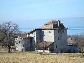 The fortified house of Chatillon | |
 Coat of arms | |
show Location of Lugrin | |
 Lugrin | |
| Coordinates: 46°24′04″N 6°39′53″E / 46.4011°N 6.6647°ECoordinates: 46°24′04″N 6°39′53″E / 46.4011°N 6.6647°E | |
| Country | France |
| Region | Auvergne-Rhône-Alpes |
| Department | Haute-Savoie |
| Arrondissement | Thonon-les-Bains |
| Canton | Évian-les-Bains |
| Intercommunality | Pays d'Évian Vallée d'Abondance |
| Government | |
| • Mayor (2020–2026) | Jacques Burnet[1] |
| Area 1 | 13.22 km2 (5.10 sq mi) |
| Population (Jan. 2018)[2] | 2,470 |
| • Density | 190/km2 (480/sq mi) |
| Demonym(s) | Lugrinois / Lugrinoises |
| Time zone | UTC+01:00 (CET) |
| • Summer (DST) | UTC+02:00 (CEST) |
| INSEE/Postal code | 74154 /74500 |
| Elevation | 373–1,248 m (1,224–4,094 ft) |
| 1 French Land Register data, which excludes lakes, ponds, glaciers > 1 km2 (0.386 sq mi or 247 acres) and river estuaries. | |


Lugrin is a commune in the Haute-Savoie department in the Auvergne-Rhône-Alpes region in south-eastern France.
See also[]
References[]
- ^ "Répertoire national des élus: les maires". data.gouv.fr, Plateforme ouverte des données publiques françaises (in French). 2 December 2020.
- ^ "Populations légales 2018". INSEE. 28 December 2020.
| Wikimedia Commons has media related to Lugrin. |
| show Authority control |
|---|
This Haute-Savoie geographical article is a stub. You can help Wikipedia by . |
Categories:
- Communes of Haute-Savoie
- Haute-Savoie geography stubs