Mátraszentimre
Mátraszentimre | |
|---|---|
Village (község) | |
 | |
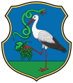
 Coat of arms | |
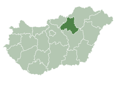 Location of Heves County in Hungary | |
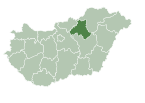
 Mátraszentimre Location of Mátraszentimre in Hungary | |
| Coordinates: 47°54′35″N 19°52′33″E / 47.90972°N 19.87583°ECoordinates: 47°54′35″N 19°52′33″E / 47.90972°N 19.87583°E | |
| Country | |
| Region | Northern Hungary |
| County | Heves County |
| Subregion | Gyöngyös District |
| Government | |
| • Mayor | András József Stuller |
| Area | |
| • Total | 21.29 km2 (8.22 sq mi) |
| Population (1 Jan. 2015) | |
| • Total | 431 |
| • Density | 20.01/km2 (51.8/sq mi) |
| Time zone | UTC+1 (CET) |
| • Summer (DST) | UTC+2 (CEST) |
| Postal code | 3235 |
| Area code | 37 |
| Website | www |

Mátraszentimre is a village in Heves County, Northern Hungary Region, Hungary.
Parts of the village[]
- Mátraszentimre
- Mátraszentistván
- Mátraszentlászló
- Bagolyirtás
- Fallóskút
- Galyatető
Sights to visit[]
- The catholic church
- Slovak country house
- Ski resort in Mátraszentistván
- Lookout tower on the Galya-tető mountain
- Mineral Museum[1]
Gallery[]

Slovak country house

Ski resort in Mátraszentistván
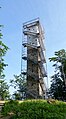
Péter-hegyese kilátó


See also[]
- List of populated places in Hungary
References[]
External links[]
- Mátraszentimre Önkormányzatának honlapja
- Mátraszentimre az utazom.com honlapján
- Légifotók Mátraszentimréről
- Sok-sok fotó a környékről
- Mátraszentimre a funiq.hu-n
 Media related to Mátraszentimre at Wikimedia Commons
This Hungarian geography article is a stub. You can help Wikipedia by . |
Categories:
- Populated places in Heves County
- Hungary geography stubs