Heves County
Heves County
Heves megye | |
|---|---|
   | |
 Flag  Coat of arms | |
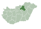
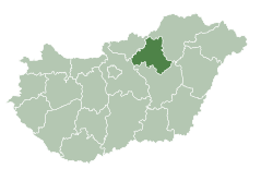 Heves County within Hungary | |
| Country | |
| Region | Northern Hungary |
| County seat | Eger |
| Districts | show
7 districts |
| Government | |
| • President of the General Assembly | Róbert Szabó (Fidesz-KDNP) |
| Area | |
| • Total | 3,637.21 km2 (1,404.33 sq mi) |
| Area rank | 16th in Hungary |
| Population (2015) | |
| • Total | 301,296[1] |
| • Rank | 14th in Hungary |
| Postal code | 300x – 304x, 32xx – 33xx |
| Area code(s) | (+36) 36, 37 |
| ISO 3166 code | HU-HE |
| Website | www |
Heves (Hungarian: Heves megye, pronounced [ˈhɛvɛʃ]) lies in northern Hungary. It lies between the right bank of the river Tisza and the Mátra and Bükk mountains. It shares borders with the Hungarian counties Pest, Nógrád, Borsod-Abaúj-Zemplén and Jász-Nagykun-Szolnok. Eger is the county seat.
Tourist sights[]
- Lake Tisza
- Bükk National Park
- Bélapátfalva, abbey
- Castle and City of Eger
- Erdőtelek Arboretum
- Feldebrő, 11th century Romanesque church
- Gyöngyös,
- Hatvan, Grassalkovich mansion
- Kisnána castle
- Noszvaj, De la Motte mansion
- Parád
- Sirok castle
- Szilv��svárad, Szalajka Valley
- Szarvaskő, castle ruins
Geography[]
Heves county is a geographically diverse area; its northern part is mountainous (the Mátra and Bükk are the two highest mountain ranges in Hungary), while at south it includes a part of the Great Hungarian Plain. From south it is bordered by Lake Tisza, the largest artificial lake in Hungary. The average temperature is between 8 and 10 °C (higher on the southern parts of the county).
Rivers[]
Highest point[]
Lowest point[]
- Kisköre (86 m.)
History[]
The county was a primary target for the Ottoman Empire during the Ottoman-Hungarian Wars where the Siege of Eger took place.
Demographics[]
Religion in Heves County (2011 census)
In 2015, it had a population of 301,296 and the population density was 83/km².
| Year | County population[2] | Change |
|---|---|---|
| 1949 | 316,273 | n/a |
| 1960 | 9.99% | |
| 1970 | -2.22% | |
| 1980 | 3.00% | |
| 1990 | -4.55% | |
| 2001 | -2.60% | |
| 2011 | -5.17% |
Ethnicity[]
Besides the Hungarian majority, the main minorities are the Roma (approx. 19,000), Germans (1,000) Slovaks (500) and Romanians (500).
Total population (2011 census): 308,882
Ethnic groups (2011 census):[3]
Identified themselves: 279,714 persons:
- Hungarians: 257,659 (92.12%)
- Gypsies: 19,312 (6.90%)
- Others and indefinable: 2,743 (0.98%)
Approx. 43,000 persons in Heves County did not declare their ethnic group at the 2011 census.
Religion[]
Religious adherence in the county according to 2011 census:[4]
- Catholic – 162,014 (Roman Catholic – 160,885; Greek Catholic – 1,098);
- Reformed – 14,729;
- Evangelical – 1,084;
- Other religions – 4,894;
- Non-religious – 43,193;
- Atheism – 3,298;
- Undeclared – 79,670.
Regional structure[]


| № | English and Hungarian names |
Area (km²) |
Population (2011) |
Density (pop./km²) |
Seat | № of municipalities |
| 1 | Bélapátfalva District Bélapátfalvai járás |
180.89 | 8,978 | 50 | Bélapátfalva | 8 |
| 2 | Eger District Egri járás |
602.05 | 87,939 | 146 | Eger | 22 |
| 3 | Füzesabony District Füzesabonyi járás |
578.55 | 30,416 | 53 | Füzesabony | 16 |
| 4 | Gyöngyös District Gyöngyösi járás |
750.78 | 73,834 | 98 | Gyöngyös | 25 |
| 5 | Hatvan District Hatvani járás |
352.16 | 51,246 | 146 | Hatvan | 13 |
| 6 | Heves District Hevesi járás |
697.68 | 35,036 | 50 | Heves (town) | 17 |
| 7 | Pétervására District Pétervásárai járás |
475.07 | 21,433 | 45 | Pétervására | 20 |
| Heves County | 3,637.25 | 308,882 | 85 | Eger | 121 | |
|---|---|---|---|---|---|---|
Politics[]
The Heves County Council, elected at the 2019 local government elections, is made up of 15 counselors,[5] with the following party composition:

| Party | Seats | Current County Assembly | |||||||||
|---|---|---|---|---|---|---|---|---|---|---|---|
| Fidesz-KDNP | 9 | ||||||||||
| Opposition coalition[a] | 6 | ||||||||||
Presidents of the General Assembly[]
| List of Presidents, from 1990[6] | |
|---|---|
| (Fidesz-KDNP) | 2014– |
Municipalities[]
Heves County has 1 urban county, 10 towns, 3 large villages and 107 villages.
- City with county rights
(ordered by population, as of 2011 census)
 Eger (56,569) – county seat
- Towns
 Gyöngyös (31,421)
 Hatvan (20,519)
 Heves (10,753)
 Füzesabony (7,880)
 Lőrinci (5,831)
 Verpelét (3,786)
 Bélapátfalva (3,092)
 Kisköre (2,869)
 Gyöngyöspata (2,586)
 Pétervására (2,326)
- Large villages
- Villages
- Abasár
- Adács
- Aldebrő
- Andornaktálya
- Apc
- Atkár
- Átány
- Balaton
- Bekölce
- Besenyőtelek
- Boconád
- Bodony
- Boldog
- Bükkszék
- Bükkszenterzsébet
- Bükkszentmárton
- Csány
- Demjén
- Detk
- Domoszló
- Dormánd
- Ecséd
- Egerfarmos
- Egerszalók
- Egerszólát
- Erdőkövesd
- Erdőtelek
- Erk
- Fedémes
- Feldebrő
- Felsőtárkány
- Gyöngyöshalász
- Gyöngyösoroszi
- Gyöngyössolymos
- Gyöngyöstarján
- Heréd
- Hevesvezekény
- Hort
- Istenmezeje
- Ivád
- Kápolna
- Kerecsend
- Kisfüzes
- Kisnána
- Kompolt
- Kömlő
- Ludas
- Maklár
- Markaz
- Mátraballa
- Mátraderecske
- Mátraszentimre
- Mezőszemere
- Mezőtárkány
- Mikófalva
- Mónosbél
- Nagyfüged
- Nagykökényes
- Nagyút
- Nagyvisnyó
- Noszvaj
- Novaj
- Ostoros
- Parádsasvár
- Petőfibánya
- Pély
- Poroszló
- Rózsaszentmárton
- Sarud
- Sirok
- Szajla
- Szarvaskő
- Szentdomonkos
- Szihalom
- Szilvásvárad
- Tarnabod
- Tarnalelesz
- Tarnaméra
- Tarnaörs
- Tarnaszentmária
- Tarnaszentmiklós
- Tarnazsadány
- Tenk
- Terpes
- Tiszanána
- Tófalu
- Újlőrincfalva
- Vámosgyörk
- Váraszó
- Visznek
- Zagyvaszántó
- Zaránk
Gallery[]
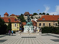
Eger, the capital of the county
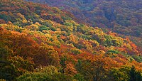
Autumn in the Bükk Mountains

Keglevich Mansion in Pétervására
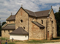
Romanesque church in Bélapátfalva

Waterfall in the Szalajka Valley near Szilvásvárad

Grassalkovich Mansion in Hatvan

Lake Tisza is the 3rd largest lake of Hungary
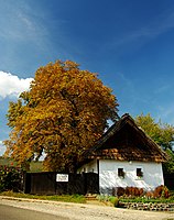
Traditional residential house in Abasár


International relations[]
Heves County has a partnership relationship with:[7][8]
|
|
References and notes[]
- References
| Wikivoyage has a travel guide for Heves County. |
- ^ nepesseg.com, population data of Hungarian settlements
- ^ népesség.com, "Heves megye népessége 1870-2015"
- ^ 1.1.6. A népesség anyanyelv, nemzetiség és nemek szerint – Frissítve: 2013.04.17.; Hungarian Central Statistical Office (in Hungarian)
- ^ 2011. ÉVI NÉPSZÁMLÁLÁS, 3. Területi adatok, 3.10 Heves megye, (in Hungarian) [1] Archived 2017-02-02 at the Wayback Machine
- ^ "Megyei közgyűlés tagjai 2019-2024 (Heves megye)". valasztas.hu. Retrieved 2019-10-29.
- ^ Önkormányzati választások eredményei (in Hungarian)
- ^ [2]
- ^ [3]
- Notes
External links[]
| Wikimedia Commons has media related to Heves County. |
| show Authority control |
|---|

- Heves County
- Counties of Hungary