Tófalu
Tófalu | |
|---|---|
Village (község) | |
 | |
 Coat of arms | |
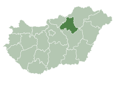 Location of Heves County in Hungary | |
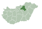
 Tófalu Location in Hungary | |
| Coordinates: 47°46′34″N 20°14′13″E / 47.77611°N 20.23694°ECoordinates: 47°46′34″N 20°14′13″E / 47.77611°N 20.23694°E | |
| Country | |
| Region | Northern Hungary |
| County | Heves County |
| District | Füzesabony |
| First mentioned | 1352 |
| Government | |
| • Mayor | Ignácz Szabolcs András (Ind.) |
| Area | |
| • Total | 14.48 km2 (5.59 sq mi) |
| Population (2015) | |
| • Total | 576 |
| • Density | 40/km2 (100/sq mi) |
| Time zone | UTC+1 (CET) |
| • Summer (DST) | UTC+2 (CEST) |
| Postal code | 3354 |
| Area code | 36 |
| Website | http://www.tofalu.hu/ |

Tófalu is a village in Heves County, Hungary.[1]
References[]
- ^ "Central Statistical Office". KSH. Retrieved 22 December 2017.
| Town (1) |
| |
|---|---|---|
| Large village (1) | ||
| Villages (14) | ||
This Hungarian geography article is a stub. You can help Wikipedia by . |
Categories:
- Populated places in Heves County
- Hungary geography stubs