Szarvaskő
Szarvaskő | |
|---|---|
Village (község) | |
 | |
 Flag  Coat of arms | |
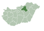
 Szarvaskő Location of Szarvaskő in Hungary | |
| Coordinates: 47°59′17″N 20°19′51″E / 47.98806°N 20.33083°E | |
| Country | |
| Region | Northern Hungary |
| County | Heves County |
| Subregion | Eger District |
| Government | |
| • Mayor | Marianna Balla Szabóné[1] |
| Area | |
| • Total | 12.59 km2 (4.86 sq mi) |
| Population (1 Jan. 2015) | |
| • Total | 325 |
| • Density | 27.32/km2 (70.8/sq mi) |
| Time zone | UTC+1 (CET) |
| • Summer (DST) | UTC+2 (CEST) |
| Postal code | 3323 |
| Area code | 36 |
| Website | www |

Szarvaskő is a village in Heves County, Northern Hungary Region, Hungary.
Geography[]
The village is located on the western border of the Bükk Mountains. Because of the picturesque landscape the village is on the path of the National Blue Trail.
Communications[]
Szarvaskő is on the between Eger and Tarnalelesz. The Eger-Putnok railway line passes through the village, and there are 2 trains per day at the Szarvaskő railway station.
Sights to visit[]
- Szarvaskő Castle Ruin
- Major-tetői kilátó (Major Lookout)
- Roman Catholic church
- Öko-Park Panzió-Kemping és Kalandpark (English: leisure-camping and adventure park)
Gallery[]

The hill with the Szarvaskő castle ruin
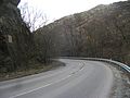
The Pyrker Strait at the border of Szarvaskő with the memorial plaque (on the left side of the picture)

The Major Lookout
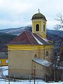
The church
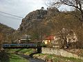
The hill with the Szarvaskő castle ruin


References[]
- ^ "Polgármester választás". Retrieved 2019-03-18.
External links[]
![]() Media related to Szarvaskő at Wikimedia Commons
Media related to Szarvaskő at Wikimedia Commons
- Official website in Hungarian
- Szarvaskő
| Authority control |
|
|---|
This Hungarian geography article is a stub. You can help Wikipedia by . |
Categories:
- Populated places in Heves County
- Hungary geography stubs