Verpelét
Verpelét | |
|---|---|
 Town hall at Verpelét | |
 Flag  Coat of arms | |
 Verpelét | |
| Coordinates: 47°50′53″N 20°13′34″E / 47.84806°N 20.22611°ECoordinates: 47°50′53″N 20°13′34″E / 47.84806°N 20.22611°E | |
| Country | |
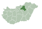
| County | Heves |
| District | Eger |
| Area | |
| • Total | 53.18 km2 (20.53 sq mi) |
| Population (1 January 2015)[1] | |
| • Total | 3,780 |
| • Density | 71/km2 (180/sq mi) |
| Time zone | UTC+1 (CET) |
| • Summer (DST) | UTC+2 (CEST) |
| Postal code | 3264, 3331, 3351 |
| Area code | (+36) 36 |
| Website | www |

Verpelét is a town since 2013, with 3,780 inhabitants end 2014, in Heves county (megye), in the Northern Hungary region.
Geography[]
This section needs expansion. You can help by . (February 2017) |
History[]
This section needs expansion. You can help by . (February 2017) |
The VERPELET post office opened on 13 October 1867, and was dependent on Postal Directory Pest.[2]
References[]
- ^ Gazetteer of Hungary, 1st January 2015. Hungarian Central Statistical Office.
- ^ Die Poststempel auf der Freimarken-Ausgabe 1867 von Österreich und Ungarn, Edwin Müller, 1930
External links[]
| Wikimedia Commons has media related to Verpelét. |
- Official website in Hungarian
| Authority control |
|
|---|
This Heves county location article is a stub. You can help Wikipedia by . |
Categories:
- Populated places in Heves County
- Heves geography stubs