Madison, Illinois
Madison | |
|---|---|
City | |
 City Hall | |
 Location of Madison in Madison County, Illinois. | |
 Location of Illinois in the United States | |
| Coordinates: 38°41′1″N 90°9′4″W / 38.68361°N 90.15111°WCoordinates: 38°41′1″N 90°9′4″W / 38.68361°N 90.15111°W | |
| Country | United States |
| State | Illinois |
| County | Madison |
| Area | |
| • Total | 17.53 sq mi (45.40 km2) |
| • Land | 13.79 sq mi (35.72 km2) |
| • Water | 3.74 sq mi (9.68 km2) |
| Population (2010) | |
| • Total | 3,891 |
| • Estimate (2019)[2] | 3,758 |
| • Density | 272.48/sq mi (105.20/km2) |
| Time zone | UTC−6 (CST) |
| • Summer (DST) | UTC−5 (CDT) |
| ZIP Code(s) | 62060 |
| Area code(s) | 618 |
| FIPS code | 17-45993 |
| Wikimedia Commons | Madison, Illinois |
| Website | cityofmadisonil |

Madison is a city in Madison and St. Clair counties in the U.S. state of Illinois. The population was 3,891 at the 2010 census.[3] It is home to World Wide Technology Raceway at Gateway and the first Bulgarian Orthodox church in the United States.
History[]
Madison was founded in 1820. There have been three villages named Madison.[4]
Geography[]
Madison is located at 38°41′1″N 90°9′4″W / 38.68361°N 90.15111°W (38.683700, -90.151047).[5]
According to the 2010 census, Madison has a total area of 17.181 square miles (44.50 km2), of which 14.55 square miles (37.68 km2) (or 84.69%) is land and 2.631 square miles (6.81 km2) (or 15.31%) is water.[6]
Demographics[]
| Historical population | |||
|---|---|---|---|
| Census | Pop. | %± | |
| 1900 | 1,979 | — | |
| 1910 | 5,046 | 155.0% | |
| 1920 | 4,996 | −1.0% | |
| 1930 | 7,661 | 53.3% | |
| 1940 | 7,782 | 1.6% | |
| 1950 | 7,963 | 2.3% | |
| 1960 | 6,861 | −13.8% | |
| 1970 | 7,042 | 2.6% | |
| 1980 | 5,301 | −24.7% | |
| 1990 | 4,629 | −12.7% | |
| 2000 | 4,545 | −1.8% | |
| 2010 | 3,891 | −14.4% | |
| 2019 (est.) | 3,758 | [2] | −3.4% |
| U.S. Decennial Census[7] | |||
At the 2000 census there were 4,545 people, 1,881 households, and 1,117 families living in the city. The population density was 648.3 people per square mile (250.3/km2). There were 2,322 housing units at an average density of 331.2 per square mile (127.9/km2). The racial makup of the city was 55.36% White, 42.13% African American, 0.29% Native American, 0.11% Asian, 0.02% Pacific Islander, 0.92% from other races, and 1.17% from two or more races. Hispanic or Latino of any race were 1.96%.[8]
Of the 1,881 households 29.8% had children under the age of 18 living with them, 31.2% were married couples living together, 22.0% had a female householder with no husband present, and 40.6% were non-families. 34.9% of households were one person and 14.7% were one person aged 65 or older. The average household size was 2.42 and the average family size was 3.13.
In the city, the age distribution of the population shows 29.8% under the age of 18, 8.6% from 18 to 24, 26.8% from 25 to 44, 19.2% from 45 to 64, and 15.5% 65 or older. The median age was 34 years. For every 100 females, there were 96.0 males. For every 100 females age 18 and over, there were 88.4 males.
The median household income was $24,828 and the median family income was $29,926. Males had a median income of $27,363 versus $21,250 for females. The per capita income for the city was $13,090. About 19.6% of families and 24.0% of the population were below the poverty line, including 35.4% of those under age 18 and 12.0% of those age 65 or over.
National Register of Historic Places[]
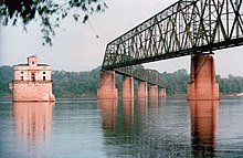
- Chain of Rocks Bridge over the Mississippi River
Notable people[]
- George Becker, president of United Steelworkers 1993-2001
- Sam Harshaney, catcher for the St. Louis Browns
- Donnie Freeman, basketball player at Illinois and in ABA and NBA
References[]
- ^ "2019 U.S. Gazetteer Files". United States Census Bureau. Retrieved July 14, 2020.
- ^ Jump up to: a b "Population and Housing Unit Estimates". United States Census Bureau. May 24, 2020. Retrieved May 27, 2020.
- ^ "Profile of General Population and Housing Characteristics: 2010 Demographic Profile Data (DP-1): Madison city, Illinois". United States Census Bureau. Retrieved January 20, 2012.
- ^ Norton, William T. (1912). Centennial History of Madison County, Illinois, and Its People, 1812 to 1912. The Lewis Publishing Co. pp. 577.
- ^ "US Gazetteer files: 2010, 2000, and 1990". United States Census Bureau. 2011-02-12. Retrieved 2011-04-23.
- ^ "G001 - Geographic Identifiers - 2010 Census Summary File 1". United States Census Bureau. Archived from the original on 2020-02-13. Retrieved 2015-12-27.
- ^ "Census of Population and Housing". Census.gov. Retrieved June 4, 2015.
- ^ "U.S. Census website". United States Census Bureau. Retrieved 2008-01-31.
External links[]
- City of Madison official website
- Reynolds, Francis J., ed. (1921). . Collier's New Encyclopedia. New York: P. F. Collier & Son Company.


| show Municipalities and communities of Madison County, Illinois, United States |
|---|
| show Municipalities and communities of St. Clair County, Illinois, United States |
|---|
| show Authority control |
|---|
- Cities in Illinois
- Cities in Madison County, Illinois
- Cities in St. Clair County, Illinois
- Illinois populated places on the Mississippi River
- Populated places established in 1820
- 1820 establishments in Illinois