Maimun Saleh Airport
Maimun Saleh Airport Bandar Udara Maimun Saleh | |||||||||||
|---|---|---|---|---|---|---|---|---|---|---|---|
| Summary | |||||||||||
| Airport type | Military, Public | ||||||||||
| Owner | Government of Indonesia | ||||||||||
| Operator | Ministry of Transportation | ||||||||||
| Serves | Sabang | ||||||||||
| Location | Sabang, Aceh, Indonesia | ||||||||||
| Elevation AMSL | 433 ft / 132 m | ||||||||||
| Coordinates | 5°52′29″N 95°20′24″E / 5.87472°N 95.34000°ECoordinates: 5°52′29″N 95°20′24″E / 5.87472°N 95.34000°E | ||||||||||
| Website | sbg | ||||||||||
| Maps | |||||||||||
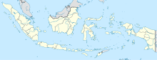
 Sumatra region in Indonesia | |||||||||||
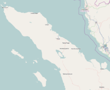 SBG Location in Northern Sumatra | |||||||||||
| Runways | |||||||||||
| |||||||||||
Sources: DGCA[2] | |||||||||||

Maimun Saleh Airport (IATA: SBG, ICAO: WITN) is a small airport with a runway length of 1,844 m (6,050 ft) and altitude of 120 m (390 ft) in Sabang, Pulau Weh, Indonesia. It is situated on the island right above the northern tip of Sumatra in the Andaman Sea. It is part of the Sabang city in Aceh province. This airport was named after one of Indonesian Air Force pilot, Maimun Saleh, who died in plane crash at Bogor on August, 1952. The airport is considered to be Indonesia's westernmost airport.
This airport is part of Indonesian Navy facility such as El Tari Airport. The nearest airport to Sabang is Sultan Iskandarmuda Airport, which is located in nearby Banda Aceh; it serves both international and domestic flights.
References[]
- ^ "Airline and Airport Code Search". IATA. Retrieved 12 April 2016.
- ^ "Page for Maimun Saleh". Indonesian DGCA.
This article about an Indonesian airport is a stub. You can help Wikipedia by . |
- Airports in Aceh
- Indonesian airport stubs