Naha Airport (Indonesia)
Naha Airport Bandar Udara Naha | |||||||||||
|---|---|---|---|---|---|---|---|---|---|---|---|
| Summary | |||||||||||
| Airport type | Public | ||||||||||
| Serves | Tahuna, Sangihe Islands, Indonesia | ||||||||||
| Elevation AMSL | 5 m / 16 ft | ||||||||||
| Coordinates | 03°40′59″N 125°31′40″E / 3.68306°N 125.52778°ECoordinates: 03°40′59″N 125°31′40″E / 3.68306°N 125.52778°E | ||||||||||
| Map | |||||||||||
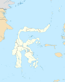 NAH Location in Sulawesi | |||||||||||
| Runways | |||||||||||
| |||||||||||

Naha Airport (IATA: NAH, ICAO: WAMH) is an airport serving the locality of Tahuna, in the Sangihe Islands, part of the North Sulawesi province of Indonesia. The airport is previously connected to Manado by daily Wings Air[4] flights.
Airlines and destinations[]
| Airlines | Destinations |
|---|---|
| Wings Air | Manado |
References[]
- ^ Airport information for WAMH at World Aero Data. Data current as of October 2006.Source: DAFIF.
- ^ Airport information for NAH at Great Circle Mapper. Source: DAFIF (effective October 2006).
- ^ Airport information for Naha Airport at Transport Search website.
- ^ "Archived copy". Archived from the original on 2009-10-31. Retrieved 2009-01-08.CS1 maint: archived copy as title (link)
Categories:
- Airports in North Sulawesi