Manto Sipi Cree Nation
Manto Sipi Cree Nation
God's River ᒪᓂᑐ ᓰᐱᐩ manito sîpiy | |
|---|---|
| God's River 86A | |
 Manto Sipi Cree Nation God's River Location of God's Lake in Manitoba | |
| Coordinates: 54°50′11″N 94°03′23″W / 54.83639°N 94.05639°WCoordinates: 54°50′11″N 94°03′23″W / 54.83639°N 94.05639°W | |
| Country | Canada |
| Province | Manitoba |
| Region | Northern |
| Government | |
| • MP (Churchill—Keewatinook Aski) | Niki Ashton (NDP) |
| • MLA (Keewatinook) | Ian Bushie (NDP) |
| Area | |
| • Total | 4.01 km2 (1.55 sq mi) |
| Elevation | 170 m (560 ft) |
| Population (2016[1]) | |
| • Total | 643 |
| • Density | 160.2/km2 (415/sq mi) |
| Time zone | UTC-6 (CST) |
| • Summer (DST) | UTC-5 (CDT) |

Gods River is a remote, isolated settlement in Northern Manitoba, Canada, and the primary settlement of the Manto Sipi Cree Nation (Cree: ᒪᓂᑐ ᓰᐱᐩ, manito sîpiy) (54°50′15″N 94°03′17″W / 54.83750°N 94.05472°W) First Nations community. The settlement is on Gods Lake at the point of outflow of the Gods River.
The community can only be reached by winter road or by air via Gods Lake Airport.
The official languages of the community are English and Cree. There is a lodge for tourists to stay for visits to the community. Population is approximately 400-700 community members as of 2021.
 Gods River on Gods Lake |
References[]
- "Gods River". Geographical Names Data Base. Natural Resources Canada. Retrieved 2011-03-01.
- "Gods River". Atlas of Canada. Natural Resources Canada. 2010-02-04. Retrieved 2011-03-01.
- ^ "God's River Census Canada data". Census Canada. Retrieved 2018-06-20.
External links[]
| Cities | 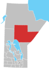 | |
|---|---|---|
| Local government districts | ||
| First Nations | ||
| Indian reserves | ||
| Indian settlements | ||
| Unorganized areas | ||
| Unincorporated communities |
| |
This Manitoba location article is a stub. You can help Wikipedia by . |
Categories:
- Keewatin Tribal Council
- Indian reserves in Northern Region, Manitoba
- Unincorporated communities in Manitoba
- Manitoba geography stubs