York Factory First Nation
| People | Swampy Cree |
|---|---|
| Treaty | Treaty 5 |
| Land | |
| Main reserve | York Landing |
| Government | |
| Chief | Leroy Constant[1] |
| Tribal Council | |
| Keewatin Tribal Council | |
| Website | |
| yffn | |
York Landing
Kawéchiwásik | |
|---|---|
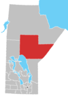
 York Landing Map showing York Landing in Manitoba | |
| Coordinates: 56°05′20″N 96°06′06″W / 56.08889°N 96.10167°W | |
| Country | |
| Province | |
| Region | Northern |
| Designated as a reserve | 1989 |
| Area | |
| • Land | 11.18 km2 (4.32 sq mi) |
| Population (2016) | |
| • Total | 443 |

York Factory First Nation (Cree: Kischi Wáskáhikan)[2]—sometimes referred to as York Landing First Nation or York Factory Cree Nation—is a First Nations community in northern Manitoba, Canada.
Its main reserve is York Landing (Kawéchiwásik; 56°05′20″N 96°06′06″W / 56.08889°N 96.10167°W), which is located along the eastern bank of the Nelson River, roughly halfway between Lake Winnipeg and Hudson Bay, as well as located 116 kilometres from Thompson, Manitoba.
As of 2016, the York Landing reserve has a population of 443 and it consists of 138 dwellings.[3] It is served by the York Landing Airport.
History[]
The Swampy Cree (Maškēkowak / nēhinawak) peoples of York Factory, Manitoba, were relocated to York Landing after the Hudson's Bay Company's York Factory location closed in 1957.[4]
In 1986, the Government of Canada transferred 9.674 km2 (2,390.5 acres) of reserve lands at York Landing to the First Nation.[2]
York Landing received official reserve status in 1989.
Demographics[]
York Factory First Nation had a registered population of 1,239 (as of August 2013), with 456 members living on the 967.40 hectares reserve of York Landing. It is governed by a chief and four councillors.[5]
References[]
- ^ http://www.yffn.ca/kawechiwasik/chief-council/
- ^ Jump up to: a b "Our Lands – York Factory First Nation". Retrieved 2021-08-17.
- ^ Census Profile, 2016 Census
- ^ "Our History – York Factory First Nation". Retrieved 2021-08-17.
- ^ "AANDC (First Nation Profiles) York Factory First Nation". 2013-09-15. Archived from the original on 2013-11-22.
| show Authority control |
|---|
Coordinates: 56°05′23″N 96°06′30″W / 56.08972°N 96.10833°W
This Manitoba location article is a stub. You can help Wikipedia by . |
- Keewatin Tribal Council
- First Nations governments in Manitoba
- Manitoba geography stubs
- First Nations in Northern Region, Manitoba
- Cree governments