Wabowden
Wabowden | |
|---|---|
 Sign for Wabowden, Manitoba, Canada | |
 Boundaries | |
 Wabowden Location in Manitoba | |
| Coordinates: 54°54′32″N 98°37′47″W / 54.90889°N 98.62972°WCoordinates: 54°54′32″N 98°37′47″W / 54.90889°N 98.62972°W | |
| Country | Canada |
| Province | Manitoba |
| Region | Manitoba |
| Government | |
| • MP | Niki Ashton |
| • MLA | Steve Ashton |
| Area | |
| • Total | 34.42 km2 (13.29 sq mi) |
| Population | |
| • Total | 442 |
| • Density | 12.8/km2 (33/sq mi) |
| Time zone | UTC−6 (CST) |
| • Summer (DST) | UTC−5 (CDT) |
| Postal code | R0B 1S0 |
| Area code(s) | 204 |
| NTS Map | 063J15 |
| GNBC Code | GBCTE |
| Website | Community of Wabowden |

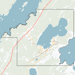
Wabowden is a community in northern Manitoba. It is situated on Provincial Trunk Highway No. 6, which is the main route between Thompson and the provincial capital, Winnipeg.
The community, which has the status of designated place in Canadian census data, had a population of 442 in the Canada 2016 Census.
History[]
The community originated in the early 20th century as a service point on the Hudson Bay Railway. Although the railway's presence in Wabowden has diminished over time, it continues to serve the community by transporting freight and passengers to the Wabowden railway station.
Wabowden's name is derived from that of a one-time railway executive, W.A. Bowden.
Climate[]
In spite of its latitude below the 55th parallel, Wabowden has a clear-cut rather than borderline subarctic climate.[2] Its climate is dominated by its long and bitterly cold winters, but the short summers are relatively warm, keeping Wabowden well below the tree line.
| Climate data for Wabowden | |||||||||||||
|---|---|---|---|---|---|---|---|---|---|---|---|---|---|
| Month | Jan | Feb | Mar | Apr | May | Jun | Jul | Aug | Sep | Oct | Nov | Dec | Year |
| Record high °C (°F) | 3 (37) |
7 (45) |
14 (57) |
30 (86) |
32 (90) |
34 (93) |
34 (93) |
32 (90) |
30 (86) |
25 (77) |
12 (54) |
4 (39) |
34 (93) |
| Average high °C (°F) | −18 (0) |
−15 (5) |
−5 (23) |
4 (39) |
12 (54) |
17 (63) |
22 (72) |
20 (68) |
13 (55) |
6 (43) |
−6 (21) |
−15 (5) |
3 (37) |
| Daily mean °C (°F) | −22 (−8) |
−20 (−4) |
−11 (12) |
−2 (28) |
6 (43) |
11 (52) |
16 (61) |
14 (57) |
8 (46) |
2 (36) |
−9 (16) |
−18 (0) |
−2 (28) |
| Average low °C (°F) | −27 (−17) |
−26 (−15) |
−18 (0) |
−8 (18) |
0 (32) |
5 (41) |
10 (50) |
8 (46) |
4 (39) |
−1 (30) |
−13 (9) |
−22 (−8) |
−7 (19) |
| Record low °C (°F) | −46 (−51) |
−44 (−47) |
−37 (−35) |
−30 (−22) |
−14 (7) |
−5 (23) |
1 (34) |
−1 (30) |
−8 (18) |
−16 (3) |
−36 (−33) |
−43 (−45) |
−46 (−51) |
| Average rainfall mm (inches) | 10 (0.4) |
10 (0.4) |
10 (0.4) |
20 (0.8) |
30 (1.2) |
70 (2.8) |
80 (3.1) |
60 (2.4) |
60 (2.4) |
20 (0.8) |
20 (0.8) |
10 (0.4) |
450 (17.7) |
| Source: [3] | |||||||||||||
Mining[]
Crowflight Minerals is currently preparing Bucko Lake Mine for rehabilitation. The mine shaft was developed in the 1970s by Falconbridge Limited.
Local media[]
Television[]
- CBWMT (channel 10) (CBC)
References[]
- ^ "Census Profile, 2016 Census". Statistics Canada, 2016 Census. 2017-04-14. Retrieved 2017-05-30.
- ^ "Wabowden, Manitoba Climate Summary". Weatherbase. Retrieved 15 July 2015.
- ^ "Wabowden, Manitoba Travel Weather Averages (Weatherbase)". Weatherbase. Retrieved 15 July 2015.
External links[]
Places adjacent to Wabowden | ||||||||||||||||
|---|---|---|---|---|---|---|---|---|---|---|---|---|---|---|---|---|
| ||||||||||||||||
| Cities | 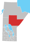 | |
|---|---|---|
| Local government districts | ||
| First Nations | ||
| Indian reserves | ||
| Indian settlements | ||
| Unorganized areas | ||
| Unincorporated communities |
| |
- Designated places in Manitoba
- Mining communities in Manitoba
- Northern communities in Manitoba
- Hudson's Bay Company trading posts