Garden Hill First Nation
Garden Hill | |
|---|---|
| Garden Hill First Nation[2][1] | |
 View of the community | |
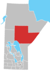
 Garden Hill Map showing Garden Hill in Manitoba | |
| Coordinates: 53°52′17″N 94°38′27″W / 53.87139°N 94.64083°W | |
| Country | |
| Province | |
| Region | Island Lake (Northern Manitoba) |
| Area (2019)[1] | |
| • Land | 73.573 km2 (28.407 sq mi) |
| Population | |
| • Total | 2,591 |
| Languages | Oji-Cree and English |

Garden Hill is the second largest of three reserves of the Island Lake region of Manitoba.
Garden Hill First Nations, the reserve's First Nations community, is located in the northeast section of the Canadian province of Manitoba on the shore of Island Lake.
Garden Hill had a population of 2,776 in the 2011 Canadian census.[3] The residents of Garden Hill speak Oji-Cree and English. It is only accessible by winter ice roads via St. Theresa Point and by air. Nearby on Island Lake are the communities of Wasagamack of the Wasagamack First Nation, St. Theresa Point of the St. Theresa Point First Nation, and the northern settlement of Island Lake.
History[]
In the early 1900s, there were no chiefs, but there were leaders called "headmen". They earned their status by establishing a reputation for generosity, service, wisdom, spirituality, courage, diplomacy, dignity, loyalty and personal magnetism. These leaders achieved status by influence, not by possession of wealth, but by the distribution of it. The shared generosity because of beliefs, values, traditions, and customs required by this behaviour. The chief with the longest time in the position was Henry Fiddler, who held the position of Chief for 22 years from 1931-1953.[citation needed]
Garden Hill First Nations once belonged to the Island Lake band,[4] who, on 13 August 1909, became a signatory of Treaty 5. In 1969, Island Lake split into four separate communities with their own separate administrations: Wasagamack, Red Sucker Lake, St. Theresa Point, and Garden Hill First Nations.[5] Today, the four communities have a Tribal Council, called , to collaborate on common interests.[5][6]
Demographics[]
The population of Garden Hill was 2,776 in the 2011 Canadian census an increase of 46.3% from 2006. In 2006 there were 1,898 residents. There were a total of 595 private dwellings. The population density was 33.7 per square kilometre on a land area of 82.48 square kilometres. The median age was 18.9.[3]
Garden Hill First Nations[]
| Treaty | Treaty 5 |
|---|---|
| Headquarters | Island Lake, Manitoba |
| Land[7] | |
| Main reserve | Garden Hill First Nation |
| Population (2021)[7] | |
| On reserve | 3972 |
| On other land | 71 |
| Off reserve | 748 |
| Total population | 4791 |
| Government[7] | |
| Chief | Dino Flett[8] |
| Tribal Council[7] | |
Garden Hill First Nations is a First Nations community, and a signatory of Treaty 5. As of February 2015, Garden Hill First Nations had a registered population of 4,567 with 3918 members living on reserve and 649 members living off reserve.[9] Members elect a chief, vice chief and seven councillors through a Custom Electoral System.[9]
Reserve lands[]
Garden Hill First Nations has the following seven reserves:[1]
| Reserve[1] | Location | Coordinates | Total area |
|---|---|---|---|
| Amik Wachink Sakahikan[10] | on | 54°15′04″N 94°58′11″W / 54.2511°N 94.9696°W | 1,339.5 ha (3,310 acres) |
| Bella Lake Exchange Lands[11] | 53°53′03″N 94°33′10″W / 53.8842°N 94.5528°W | 174.80 ha (431.9 acres) | |
| Garden Hill First Nation[12] | 53°52′17″N 94°38′27″W / 53.8714°N 94.6408°W | 7,357.30 ha (18,180.3 acres) | |
| Pe-Ta-Waygamak[13] | on the south shore of Island Lake; east of Garden Hill | 53°39′38″N 94°25′42″W / 53.6606°N 94.4283°W | 6,092.30 ha (15,054.4 acres) |
| Seeseep Sakahikan[14] | northeast of Island Lake; 30 km (19 mi) west of Red Sucker Lake | 53°56′14″N 94°57′56″W / 53.9371°N 94.9655°W | 1,361.80 ha (3,365.1 acres) |
| Wesha Kijay Wasagamach[15] | on the northwest shore of Wasakamak Bay on Beaver Hill Lake | 54°22′39″N 95°00′08″W / 54.3776°N 95.0022°W | 203.50 ha (502.9 acres) |
| Wolf River[16] | on the eastern end of Island Lake | 53°52′04″N 93°58′52″W / 53.8678°N 93.9811°W | 1,575.10 ha (3,892.2 acres) |
Education[]
There are two schools in Garden Hill. The elementary school is named Kistiganwacheeng Elementary School and the secondary school is called Garden Hill First Nation High School. Garden Hill Student Services office is located in Winnipeg, the office handles post-secondary students that attend various institutions.
Gallery[]
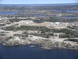
Garden Hill looking north

Island Lake/Garden Hill
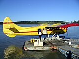
Island Lake Lodge dock
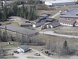
Garden Hill Health Centre


References[]
- ^ Jump up to: a b c d "Reserves/Settlements/Villages: Garden Hill First Nations". Indigenous and Northern Affairs Canada. Retrieved August 28, 2021.
- ^ "Garden Hill First Nation". Government of Canada. Retrieved August 28, 2021.
- ^ Jump up to: a b "Canada Census 2011". Retrieved 2014-01-14.
- ^ "About Us". St. Theresa Point First Nation. Retrieved 2021-08-14.
- ^ Jump up to: a b "St. Theresa Point First Nation History". St. Theresa Point First Nation. Retrieved 2021-08-14.
- ^ "Garden Hill First Nation" (PDF). Archived from the original (PDF) on 2013-10-08. Retrieved 2015-03-15.
- ^ "First Nation Detail: Garden Hill First Nations". Indigenous and Northern Affairs Canada. Retrieved August 28, 2021.
- ^ Bergen, Rachel (January 20, 2021). "Military help arrives in Garden Hill First Nation to battle 'alarming spike' in COVID-19". CBC News. Retrieved August 28, 2021.
- ^ Jump up to: a b "AANDC (Registered Population)". Archived from the original on 2014-03-05. Retrieved 2015-01-14.
- ^ "Natural Resources Canada-Canadian Geographical Names (Amik Wachink Sakahikan)". Retrieved 2015-03-15.
- ^ "Natural Resources Canada-Canadian Geographical Names (Bella Lake Exchange Lands)". Retrieved 2015-03-15.
- ^ "Natural Resources Canada-Canadian Geographical Names (Garden Hill First Nation)". Retrieved 2015-03-15.
- ^ "Natural Resources Canada-Canadian Geographical Names (Pe-Ta-Waygamak)". Retrieved 2015-03-15.
- ^ "Natural Resources Canada-Canadian Geographical Names (Seeseep Sakahikan)". Retrieved 2015-03-15.
- ^ "Natural Resources Canada-Canadian Geographical Names (Wesha Kijay Wasagamach)". Retrieved 2015-03-15.
- ^ "Natural Resources Canada-Canadian Geographical Names (Wolf River)". Retrieved 2015-03-15.
External links[]
Coordinates: 53°53′00″N 94°38′56″W / 53.88333°N 94.64889°W
| show Authority control |
|---|
- Island Lake Tribal Council
- First Nations in Northern Region, Manitoba
- Indian reserves in Northern Region, Manitoba