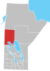
Mosakahiken Cree Nation
Moose Lake 31A | |
|---|---|
Indian Reserve | |
 Moose Lake 31A | |
| Coordinates: 53°42′33″N 100°19′32″W / 53.70917°N 100.32556°WCoordinates: 53°42′33″N 100°19′32″W / 53.70917°N 100.32556°W | |
| Country | |
| Province | |
| Census division | No. 21 |
| Region | Northern |
| Area | |
| • Land | 3.36 km2 (1.30 sq mi) |
| Elevation | 260 m (840 ft) |
| Population (2016)[1] | |
| • Total | 1,124 |
| • Density | 334.9/km2 (867/sq mi) |
| Time zone | UTC−5 (CST) |
| • Summer (DST) | UTC−6 (CDT) |
| Mosakahiken Cree Nation | |
| Headquarters | Moose Lake, Manitoba |
| Land | |
| Main reserve | Moose Lake 31A |
| Other reserve(s) | Moose Lake 31C, 31D, 31G, and 31J
|
| Government | |
| Chief | Vincent Bercier |
| Tribal Council | |
| [2] | |
The Mosakahiken Cree Nation is a First Nations located around the community of Moose Lake in northern Manitoba.
Its main reserve is Moose Lake 31A; other reserve lands in its possession include: Moose Lake 31C, Moose Lake 31D, Moose Lake 31G, and Moose Lake 31J. They are members of the .
References[]
- ^ Jump up to: a b https://www12.statcan.gc.ca/census-recensement/2016/dp-pd/prof/details/page.cfm?Lang=E&Geo1=CSD&Code1=4621058&Geo2=PR&Code2=46&SearchText=Moose%20Lake%2031A&SearchType=Begins&SearchPR=01&B1=All&GeoLevel=PR&GeoCode=4621058&TABID=1&type=0
- ^ https://swampycree.com/mosakahiken-cree-nation/
External links[]
Categories:
- First Nations governments in Manitoba
- Swampy Cree Tribal Council
- First Nations in Northern Region, Manitoba

