Menlo Park, California
Menlo Park | |
|---|---|
City | |
| City of Menlo Park | |
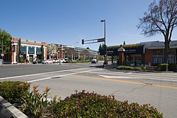 Downtown Menlo Park | |
|
| |
 Location in San Mateo County and the state of California | |
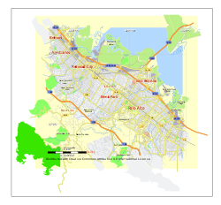 Menlo Park street map, California | |
 Menlo Park Location in California | |
| Coordinates: 37°27′10″N 122°11′00″W / 37.45278°N 122.18333°WCoordinates: 37°27′10″N 122°11′00″W / 37.45278°N 122.18333°W | |
| Country | United States |
| State | California |
| County | San Mateo |
| Incorporated | November 23, 1927[1] |
| Government | |
| • Mayor | Drew Combs [2] |
| Area | |
| • Total | 17.38 sq mi (45.03 km2) |
| • Land | 9.99 sq mi (25.87 km2) |
| • Water | 7.39 sq mi (19.15 km2) 43.79% |
| Elevation | 72 ft (22 m) |
| Population | |
| • Total | 32,026 |
| • Estimate (2019)[6] | 34,698 |
| • Density | 3,473.27/sq mi (1,341.04/km2) |
| Time zone | UTC−8 (Pacific) |
| • Summer (DST) | UTC−7 (PDT) |
| ZIP codes | 94025–94029 |
| Area code | 650 |
| FIPS code | 06-46870 |
| GNIS feature IDs | 1659108, 2411079 |
| Website | www |


Menlo Park is a city at the eastern edge of San Mateo County within the San Francisco Bay Area of California in the United States. It is bordered by San Francisco Bay on the north and east; East Palo Alto, Palo Alto, and Stanford to the south; and Atherton, North Fair Oaks, and Redwood City to the west. It is one of the most educated cities in California and the United States; nearly 70% of residents over 25 have earned a bachelor's degree or higher.[7] It had 32,026 residents at the 2010 United States Census, and an estimated 34,698 by 2019.[8][9] It is home to the corporate headquarters of Facebook, and is where Google and Round Table Pizza were founded.
History[]

The area of Menlo Park was inhabited by the Ohlone people when the Portolá expedition arrived in 1769.[10]
In 1795, the Rancho de las Pulgas land grant was made that included the area of the current city.
In 1851, two Irish immigrants, Dennis J. Oliver and his brother-in-law D. C. McGlynn, purchased a 1,700-acre (690 ha) tract of land on the former Rancho de las Pulgas.[11] In 1854, they erected a gate with a wooden arch bearing the inscription "Menlo Park" and the date "August 1854" at the entrance to their property (now the intersection of Middle Ave and El Camino Real).[12][13] The word "Menlo" derived from the owners' former home of Menlo (or Menlough) in County Galway, Ireland, and is an anglicized version of the original Irish name of the place, Mionloch, meaning "middle lake".[11][14]
In 1863, the San Francisco and San Jose Rail Road had built the railroad from San Francisco to as far as Mayfield (now California Avenue station in Palo Alto) and started running trains to the area.[15] They named a nearby station "Menlo Park" after the sign.[11] The 1867 station building still stands on the platform of the current Caltrain station, used by the local Chamber of Commerce. It holds the record as the oldest, continually operating train station in California.[16] The town of Menlo Park grew up around this station, becoming a popular home for San Francisco businessmen.[11] A post office was established in 1870, and the city was incorporated in 1874 (it dissolved after two years, but later was permanently incorporated in 1927).[12][17] The original arch, which gave its name to the stations and ultimately, the city, survived until 1922, when the original arch was destroyed in an automobile accident.[11] The origin of the name of Menlo Park, California (circa 1850)[13] antedates any work done by Thomas Edison (circa 1876) in Menlo Park, New Jersey; Menlo Park, New Jersey, was named after Menlo Park, California.[18]
In 1917-18, a large portion of Menlo Park was the site of Camp Fremont, a training camp for, at its height, 27,000 men being sent to fight in World War I. It did not last long (the camp was dismantled after the war), but army engineers paved the first streets in Menlo Park and laid the first water and gas lines.[19][20] The army did retain the camp hospital, and it is now the site of a Veterans Administration Hospital off of Willow Road in Menlo Park. In the autumn of 1918, a flu pandemic hit Camp Fremont and killed 147.[21]
At the start of World War II, the US government bought the 260-acre (110 ha) estate of Timothy Hopkins from his widow and created the Palo Alto General Hospital, later renamed the Dibble General Hospital (after Colonel John Dibble, who was killed in 1943). After the war ended, some of the land was sold to the city and became the sites of the main library and city hall. More of the land was bought by Stanford University to house the increase in students due to the G.I. Bill; the area was known as the "Stanford Village", which existed as student housing until the mid-1960s. This land also was the site of the Stanford Research Institute (now SRI International) starting in 1947; between 1955 and 1968, SRI bought the rest of the Stanford Village.[22][23][24]
In the 1960s, the former 600-acre (240 ha) estate of Frederick W. Sharon (1859–1914) (son of Senator William Sharon) and his wife, Louise Tevis Breckinridge Sharon (1858–1938; daughter of Lloyd Tevis and divorced wife of John Witherspoon Breckinridge), in the hills of south west Menlo Park was developed and called "Sharon Heights".[25][26]
In 2015, the Menlo Park Historical Association (MPHA) began a project to raise funds for and build a replica of the original Menlo Park gates. The chosen site was at 800 Alma Street in front of the Menlo Park public library. The replica was completed in 2019. On March 17, 2019, Menlo Park Mayor Ray Mueller officially dedicated the reproduction of the Menlo Gates.[27][28]
Geography[]
According to the United States Census Bureau, the city has a total area of 17.4 square miles (45 km2), of which 9.8 square miles (25 km2) are land and 7.6 square miles (20 km2) are covered by water. Menlo Park is long and narrow on a northeast to southwest axis. The northeast portion borders the San Francisco Bay and includes the Dumbarton Bridge that connects Menlo Park to Fremont on the east side of the bay. The city shoreline includes the city's largest park, Bedwell Bayfront Park (160 acres (65 ha)) and the Don Edwards San Francisco Bay National Wildlife Refuge.[29] San Francisquito Creek marks much of the southeast border of the city. West Menlo Park (not part of the city despite its name) along Alameda de las Pulgas nearly separates the southwestern part of the city (known as Sharon Heights) from the rest. The extreme southwest is clipped by Interstate 280.
The Bayshore Freeway (part of U.S. Route 101) traverses Menlo Park northwest to southeast near the shoreline and somewhat parallel to it to the southwest is El Camino Real. The intersection of El Camino Real and Santa Cruz Avenue is considered the heart of the city. Nearby, the Menlo Park Civic Center is bounded by Ravenswood Avenue, Alma Street, Laurel Street, and Burgess Drive. It contains the council offices, library, police station, and Burgess Park, which has various recreational facilities. Other major roads include Sand Hill Road in the Sharon Heights area.
The residential areas of Menlo Park can be unofficially divided into several neighborhoods. From "east" (northeast toward San Francisco Bay) to "west" (southwest toward the Pacific Coast), they are defined by the Palo Alto Weekly as:[17] Belle Haven is the only neighborhood east of Route 101; much of the rest of that area is business or protected land. Between 101 and the roughly parallel Middlefield Road are the neighborhoods of the Willows, Suburban Park, Lorelei Manor, Flood Triangle, Vintage Oaks, and South of Seminary (the seminary being Saint Patrick's Seminary). Between Middlefield and El Camino Real are the Caltrain track and Felton Gables, Linfield Oaks, and Park Forest. West of El Camino until the foothills of the Peninsula are the neighborhoods of Downtown Menlo Park, Central Menlo Park, and Allied Arts (sometimes also known as Stanford Park, it is named for the Allied Arts Guild in it). In the hills are Sharon Heights and Stanford Hills. Several other neighborhoods are closely associated with Menlo Park but are actually in unincorporated San Mateo county; these include Menlo Oaks and Fair Oaks (latter part of the North Fair Oaks census area) between Bayshore and Middlefield, University Heights (also known as West Menlo Park) between Sharon Heights and most of the rest of the city, and Stanford Weekend Acres, which is somewhat near Stanford Hills.
Demographics[]
| Historical population | |||
|---|---|---|---|
| Census | Pop. | %± | |
| 1930 | 2,254 | — | |
| 1940 | 3,258 | 44.5% | |
| 1950 | 13,587 | 317.0% | |
| 1960 | 26,957 | 98.4% | |
| 1970 | 26,826 | −0.5% | |
| 1980 | 26,438 | −1.4% | |
| 1990 | 28,040 | 6.1% | |
| 2000 | 30,785 | 9.8% | |
| 2010 | 32,026 | 4.0% | |
| 2019 (est.) | 34,698 | [6] | 8.3% |
| U.S. Decennial Census[30] | |||
2010[]
The 2010 United States Census[31] reported that Menlo Park had a population of 32,026. Its population density was 3,271.3 people per square mile (1,263.1/km2). The racial makeup of Menlo Park was 22,494 (70.2%) White, 1,551 (4.8%) African American, 156 (0.5%) Native American, 3,157 (9.9%) Asian, 454 (1.4%) Pacific Islander, 2,776 (8.7%) from other races, and 1,438 (4.5%) from two or more races. Hispanics or Latinos of any race were 18.4% of the population, most of whom (4,303) were of Mexican ancestry.
The Census reported that 31,181 people (97.4% of the population) lived in households, 599 (1.9%) lived in noninstitutionalized group quarters, and 246 (0.8%) were institutionalized.
Of the 12,347 households, 33.3% had children under the age of 18 living in them, 49.9% were opposite-sex married couples living together, 8.4%had a female householder with no husband present, and 3.0% had a male householder with no wife present. About 5.2% were unmarried opposite-sex partnerships, and 0.8% were same-sex married couples or partnerships. About 29.7% were made up of individuals, and 11.1% had someone living alone who was 65 years of age or older. The average household size was 2.53. The average family size was 3.20.
In terms of age, 7,805 residents (24.4%) were under the age of 18, 1,817 people (5.7%) aged 18 to 24, 9,563 people (29.9%) aged 25 to 44, 8,263 people (25.8%) aged 45 to 64, and 4,578 people (14.3%) were 65 years of age or older. The median age was 38.7 years. For every 100 females, there were 93.7 males. For every 100 females age 18 and over, there were 91.5 males.
The 13,085 housing units averaged 1,336.6 per square mile (516.1/km2), of which 6,927 (56.1%) were owner-occupied, and 5,420 (43.9%) were occupied by renters. The homeowner vacancy rate was 1.1%; the rental vacancy rate was 5.2%; 18,972 people (59.2% of the population) lived in owner-occupied housing units and 12,209 people (38.1%) lived in rental housing units.
|
2000[]
As of the census[33] of 2009, there were 33,690 people, 12,543 households, and 7,248 families residing in the city. The population density was 3,441.3 inhabitants per square mile (1,328.7/km2). There were 14,026 housing units at an average density of 1,432.7 per square mile (553.2/km2). 64.2% spoke English, 19.5% Spanish, other Indo-European 4.2%, 4.6% Chinese or Mandarin, and other language 0.7%, as their first language from estimate census 2009.
There were 12,543 households, out of which 25.8% had children under the age of 18 living with them, 41.5% were married couples living together, 10.8% had a female householder with no husband present, and 45.67% were non-families. 35.1% of all households were made up of individuals, and 11.1% had someone living alone who was 65 years of age or older. The average household size was 2.46 and the average family size was 3.15.
In the city, the population was spread out, with 25.8% under the age of 18, 9.1% from 18 to 24, 31.5% from 25 to 44, 20.4% from 45 to 64, and 14.2% who were 65 years of age or older. The median age was 32 years. For every 100 females, there were 94.0 males. For every 100 females age 18 and over, there were 90.6 males.
As of the 2000 estimate census, the median income for a household in the city was $82,609. Males had a median income of $77,766 versus $59,101 for females. The per capita income for the city was $51,341. About 5.9% of families and 7.3% of the population were below the poverty line, including 9.8% of those under age 18 and 8.7% of those over age 64. As of 2009 the median income for a family was $123,251.[34]
Government and politics[]
City Council members are elected at-large to staggered four-year terms, in nonpartisan municipal elections every two years.[35]
County, state and federal representation[]
On the San Mateo County Board of Supervisors, Menlo Park is split between Supervisorial District 3 (west of El Camino Real) and Supervisorial District 4 (east of El Camino Real),[36] currently represented by Don Horsley and Warren Slocum, respectively.
In the California State Legislature, Menlo Park is in the 13th Senate District, represented by Democrat Josh Becker, and in the 24th Assembly District, represented by Democrat Marc Berman.[37]
In the United States House of Representatives, Menlo Park is split between California's 14th (east of Bayshore) and 18th (west of Bayshore) congressional districts,[38] represented by Jackie Speier (D–Hillsborough) and Anna Eshoo (D–Atherton), respectively.[39]
According to the California Secretary of State, as of February 10, 2019, Menlo Park has 19,339 registered voters—9,984 (51.6%) of whom are registered Democrats, 2,989 (15.5%) registered Republicans, and 5,683 (29.4%) undeclared.[40]
Education[]
For primary schools, the central portions of Menlo Park are served by the Menlo Park City School District, while the Belle Haven neighborhood and VA hospital are served by the Ravenswood City School District, and the Sharon Heights and Stanford Hills neighborhoods served by the Las Lomitas Elementary School District. For high school, Menlo Park is part of the Sequoia Union High School District, with all of Menlo Park falling into the boundaries of Menlo-Atherton High School or TIDE Academy, a small high school established in 2019. Catholic parochial schools are St. Raymond Catholic Elementary School and Nativity Elementary School.[41] Peninsula School is a private progressive primary school.[42] Trinity School is an Episcopalian elementary school.
Private schools include Phillips Brooks School, a pre-K to 5th grade institution with about 290 students and Alto International School, formerly known as German-American International School, with about 315 students, K-12, is also in the city.[43]
For higher education, Saint Patrick's Seminary and University is a Catholic seminary in Menlo Park. Fuller Theological Seminary, an evangelical Christian school, has a branch campus in Menlo Park.[44]
There are two libraries, the Main branch and the Belle Haven branch. As part of the Peninsula Library System, they share many resources with other nearby libraries.
Economy[]
Much of Menlo Park's economy revolves around the companies on Sand Hill Road, consisting of venture capital, private equity, financial services, law firms, and other professional service companies and investment vehicles focusing on technology. Geron, Katerra, Robert Half International, Exponent, and SRI International are among the companies based in Menlo Park. Facebook moved its headquarters to the former campus of Sun Microsystems in Menlo Park in December 2011.
Top employers[]
In 2012, Facebook announced it would be Menlo Park's biggest employer, with 6,600 employees.[45] According to the city's 2020 Comprehensive Annual Financial Report,[46] the city's top employers were:
| # | Employer | # of Employees |
|---|---|---|
| 1 | 17,000 | |
| 2 | SRI International | 800 |
| 3 | Intersect ENT | 402 |
| 4 | Grail | 340 |
| 5 | Pacific Biosciences | 320 |
| 6 | City of Menlo Park | 287 |
| 7 | 286 | |
| 8 | United Parcel Service | 275 |
| 9 | Safeway | 238 |
| 10 | Exponent | 229 |
Notable people[]
- Joan Baez, folk singer
- Isaac Baron, professional poker player
- Lindsey Buckingham, musician
- Henry Cowell, composer
- Brandon Crawford, San Francisco Giants shortstop
- Abby Dahlkemper, Professional soccer player, 2019 World Cup champion with USWNT
- Tierna Davidson, professional soccer player, 2019 World Cup champion with USWNT
- Marion Dorn, textile designer
- Steve Duda, musician and DJ
- Jeanne DuPrau, author
- David Eagleman, neuroscientist and author
- Nancy Farmer, author
- Jerry Garcia, founding member of The Grateful Dead
- Paul Goldstein (born 1976), tennis player and coach
- Ari Greenberg (born 1981), world junior contract bridge champion
- Vince Guaraldi, jazz musician known for composing music for the Peanuts animated specials
- Chris Gulker, photographer, writer
- Jack Herrick, founder of wikiHow
- Jon Huntsman, Jr., former Utah governor
- Ken Kesey, author
- William R. Larson, founder of Round Table Pizza
- Milton Latham, railroad baron and politician
- Josie Maran (born 1978), supermodel
- Abraham Maslow, co-founder of Humanistic Psychology
- Bob Melvin (born 1961), Major League Baseball player and manager
- Fred Moore, political activist
- John Naber, Olympic swimmer
- Stevie Nicks, musician
- Elizabeth Osborn, equestrian vaulter
- Robert Rich, musician
- Ariel Rittenhouse, Olympic diver
- Secondhand Serenade, rock band founded in Menlo Park
- Ram Shriram, founding investor of Google
- Courtney Thorne-Smith, actress
- Thorstein Veblen, sociologist known for "Theory of the Leisure Class"
- John Vesely, musician/songwriter
- Bob Weir, founding member of The Grateful Dead
- Marco Zappacosta, co-founder of Thumbtack
Sister cities[]
 Bizen, Japan[47]
 Galway, Ireland
 Kochi, India
See also[]
- Holy Cross Cemetery (Menlo Park, California)
- Menlo Park, New Jersey
- Menlo Park (Pretoria, South Africa)
References[]
- ^ "California Cities by Incorporation Date". California Association of Local Agency Formation Commissions. Archived from the original (Word) on October 17, 2013. Retrieved August 25, 2014.
- ^ "City Council". City of Menlo Park. Retrieved December 16, 2014.
- ^ "2019 U.S. Gazetteer Files". United States Census Bureau. Retrieved July 1, 2020.
- ^ "Menlo Park". Geographic Names Information System. United States Geological Survey. Retrieved December 19, 2014.
- ^ "Menlo Park (city) QuickFacts". United States Census Bureau. Archived from the original on September 1, 2012. Retrieved April 13, 2015.
- ^ Jump up to: a b "Population and Housing Unit Estimates". United States Census Bureau. May 24, 2020. Retrieved May 27, 2020.
- ^ Schwartz, Carly (November 17, 2011). "California's Most Educated Cities: Palo Alto, Los Altos Top the List". The Huffington Post Online. Retrieved September 9, 2012.
- ^ "Census 2010: Table 3A – Total Population by Race (Hispanic exclusive) and Hispanic or Latino: 2010". California Department of Finance. Archived from the original (Excel) on December 3, 2013. Retrieved March 22, 2010.
- ^ "U.S. Census Bureau QuickFacts: Menlo Park city, California". www.census.gov. Retrieved January 28, 2018.
- ^ "CHL # 2 Portolá Journey's End San Mateo". www.californiahistoricallandmarks.com. Retrieved July 2, 2019.
- ^ Jump up to: a b c d e Hoover, Mildred Brooke; Douglas E Kyle (2002). Historic Spots in California (4th ed.). Stanford, CA: Stanford University Press. p. 405. ISBN 978-0-8047-4483-6.
- ^ Jump up to: a b Durham, David L (1998). California's Geographic Names: A Gazetteer of Historic and Modern Names of the State. Clovis, CA: Word Dancer Press. p. 662. ISBN 978-1-884995-14-9.
- ^ Jump up to: a b Stanger, 1963. pg. 109
- ^ Killelea, Patrick (2011). "Visiting Menlough in Ireland, origin of Menlo Park's name". InMenlo.com. Retrieved August 31, 2020.
- ^ "Menlo Park history". City of Menlo Park - Official Website. Retrieved February 5, 2017.
- ^ "Menlo Park's Historic Railroad Station". Silicon Valley and Beyond. January 28, 2015. Retrieved January 28, 2020.
- ^ Jump up to: a b "Menlo Park neighborhoods". Palo Alto Online. February 9, 2017. Retrieved February 10, 2017.
- ^ "The Origin of New Jersey Place Names", New Jersey Public Library Commission, May 1945, p. 20.
- ^ Kazak, Don (April 13, 1994). "The Peninsula mobilizes for war". Palo Alto Online. Archived from the original on May 25, 2017. Retrieved February 5, 2017.
- ^ "Historic California Posts: Camp Fremont". www.militarymuseum.org. Retrieved February 5, 2017.
- ^ United States War Dept. (1919). War Department Annual Report, Vol. 1. p. 2157.
- ^ "History of the District & Community / Thurlow Estate becomes Dibble General Hospital becomes SRI Int". Menlo Park City School District. Retrieved February 5, 2017.
- ^ "Dibble General Hospital". www.militarymuseum.org. Retrieved February 5, 2017.
- ^ "Corporate History |". SRI International. Archived from the original on January 22, 2017. Retrieved February 5, 2017.
- ^ Svanevik, Michael; Burgett, Shirley (November 30, 2016). "Matters Historical: From San Francisco to Europe to Menlo Park – The Mercury News". The Mercury News. Retrieved February 6, 2017.
- ^ "MLS 301 - Sharon Heights/Standford Hills - Silicon Valley and Beyond". Silicon Valley and Beyond. Retrieved February 6, 2017.
- ^ Clifford, Jim. "A St. Patrick's Day present for Menlo Park". San Mateo Daily Journal. Retrieved February 13, 2021.
- ^ "Menlo Gates officially dedicated, fittingly on St. Patrick's Day". InMenlo. March 17, 2019. Retrieved February 13, 2021.
- ^ "Bedwell Bayfront Park". Menlo Park, CA. Retrieved February 4, 2017.
- ^ "Census of Population and Housing". Census.gov. Retrieved June 4, 2015.
- ^ "2010 Census Interactive Population Search: CA – Menlo Park city". U.S. Census Bureau. Archived from the original on July 15, 2014. Retrieved July 12, 2014.
- ^ "QuickFacts: Menlo Park city, California". United States Census. Retrieved October 1, 2015.
- ^ "U.S. Census website". United States Census Bureau. Retrieved January 31, 2008.
- ^ "Best places to live 2008". CNN. Archived from the original on October 23, 2013.
- ^ "Elections". City of Menlo Park. Retrieved February 2, 2015.
- ^ "County of San Mateo Board of Supervisors". City of Menlo Park. Retrieved February 2, 2015.
- ^ "Statewide Database". UC Regents. Archived from the original on February 1, 2015. Retrieved November 20, 2014.
- ^ "Communities of Interest – City". California Citizens Redistricting Commission. Archived from the original on September 30, 2013. Retrieved September 27, 2014.
- ^ "California's 14th Congressional District - Representatives & District Map". Civic Impulse, LLC. Retrieved March 13, 2013.
- ^ "CA Secretary of State – Report of Registration – February 10, 2019" (PDF). ca.gov. Retrieved March 12, 2019.
- ^ "Schools Directory". Archdiocese of San Francisco. Archived from the original on March 19, 2015. Retrieved November 2, 2016.
- ^ "Quick Facts". Peninsula School. Archived from the original on October 18, 2015. Retrieved November 2, 2016.
- ^ Mahbubani, Rhea (March 18, 2015). "German-American International School will move to old Menlo Oaks campus this fall". San Jose Mercury News. Retrieved November 2, 2016.
- ^ "Fuller Bay Area". Fuller Theological Seminary. Archived from the original on July 25, 2014. Retrieved November 2, 2016.
- ^ Guynn, Jessica (May 29, 2012). "Menlo Park set to approve Facebook campus expansion plan". Los Angeles Times.
- ^ City of Menlo Park, California Comprehensive Annual Financial Report For the Fiscal Year Ended June 30, 2020
- ^ "Sister City program | City of Menlo Park - Official Website".
Note[]
- Stanger, Frank M. South from San Francisco: The Life Story of San Mateo County 1963, publisher: San Mateo County Historical Association
External links[]
| Wikivoyage has a travel guide for Menlo Park. |
| Wikimedia Commons has media related to Menlo Park, California. |
- Official website

- Menlo Park Chamber of Commerce
- Menlo Park Library
- Menlo Park Historical Association
| show San Francisco Bay Area |
|---|

| show Municipalities and communities of San Mateo County, California, United States |
|---|

| show Authority control |
|---|
- Menlo Park, California
- 1927 establishments in California
- Cities in San Mateo County, California
- Cities in the San Francisco Bay Area
- Incorporated cities and towns in California
- Life sciences industry
- Populated coastal places in California
- Populated places established in 1927