Mount Vernon West station
Mount Vernon West | |||||||||||
|---|---|---|---|---|---|---|---|---|---|---|---|
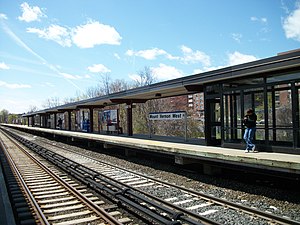 The two center tracks at Mount Vernon West station looking south | |||||||||||
| Location | 1 Mount Vernon Avenue, Mount Vernon, New York | ||||||||||
| Coordinates | 40°54′47″N 73°51′01″W / 40.9130°N 73.8502°WCoordinates: 40°54′47″N 73°51′01″W / 40.9130°N 73.8502°W | ||||||||||
| Line(s) | Harlem Line | ||||||||||
| Platforms | 2 island platforms | ||||||||||
| Tracks | 4 | ||||||||||
| Connections | Bee-Line Bus System 7, 26, 91 | ||||||||||
| Construction | |||||||||||
| Parking | 221 spaces | ||||||||||
| Disabled access | Yes | ||||||||||
| Other information | |||||||||||
| Fare zone | 3 | ||||||||||
| History | |||||||||||
| Opened | 1914[1] | ||||||||||
| Electrified | 700V (DC) third rail | ||||||||||
| Previous names | Mount Vernon (????–1974) | ||||||||||
| Passengers | |||||||||||
| 2007 | 317,512 | ||||||||||
| Services | |||||||||||
| |||||||||||
| Former services | |||||||||||
| |||||||||||

Mount Vernon West station is a commuter rail stop on the Metro-North Railroad's Harlem Line, located in Mount Vernon, New York. It is the southernmost stop on the Harlem Line in Westchester County, New York. It is 13.1 miles (21.1 km) from Grand Central Terminal and travel time there is approximately 32 minutes. Its ticket office and waiting area are at the bottom level of the Bank of New York building on Mount Vernon Avenue.
The station is the southernmost station in the Zone 3 Metro-North fare zone.
History[]
The Mount Vernon West station was originally built in the early 1840s by the New York and Harlem Railroad along the median of what is today MacQuestor Parkway just south of Mount Vernon Avenue. The line was electrified and realigned in southern Mount Vernon by the New York Central and Hudson River Railroad and commissioned the architectural firm of Warren and Wetmore to build a new station along the realigned segment in 1914,[2] although the bridge over Mount Vernon Avenue was built in 1910. As with most NYCRR stations in Westchester County, the station became a Penn Central station once the NYC & Pennsylvania Railroads merged in 1968, and eventually became part of the MTA's Metro-North Railroad. As of August 2006, daily commuter ridership was 1,172 and there are 221 parking spots.[3] The station house which is addressed at 156 South West Street and still bears the name New York Central Railroad on its façade,[4] is used primarily for retail, and tickets can be purchased from beneath the platforms.
Station layout[]
The station has two slightly offset high-level island platforms, each 12 cars long.[5]: 10
| P Platform level |
Track 4 | ← Harlem Line toward Grand Central (Wakefield) |
| Island platform, doors will open on the left or right | ||
| Track 2 | ← Harlem Line toward Grand Central (Wakefield) ← Harlem Line express service does not stop here | |
| Track 1 | Harlem Line express service does not stop here → Harlem Line toward North White Plains (Fleetwood) → | |
| Island platform, doors will open on the left or right | ||
| Track 3 | Harlem Line toward North White Plains (Fleetwood) → | |
| G | Street level | Exit/entrance and buses |
References[]
- ^ Existing Railroad Stations in Westchester County, New York
- ^ Mount Vernon; G.W. Bromley & Co., 34 Pine Street, New York, 1914 (David Rumsey Map Collection)
- ^ New York Times 2006 Metro-North commuter rail info
- ^ DanTD (April 21, 2011). File:Mount Vernon West Station; NYCRR Building.JPG (photograph). Retrieved November 15, 2012.
{{cite AV media}}: External link in|people= - ^ "Metro-North Railroad Track & Structures Department Track Charts Maintenance Program Interlocking Diagrams & Yard Diagrams 2015" (PDF). Metro-North Railroad. 2015. Retrieved January 28, 2019.
External links[]
 Media related to Mount Vernon West (Metro-North station) at Wikimedia Commons
- Metro-North Railroad stations in New York (state)
- Former New York Central Railroad stations
- Mount Vernon, New York
- Railway stations in the United States opened in 1914
- Warren and Wetmore buildings
- Railway stations in Westchester County, New York
- 1914 establishments in New York (state)
- Transportation in Westchester County, New York