Mtskheta Municipality
Mtskheta Municipality
მცხეთის მუნიციპალიტეტი | |
|---|---|
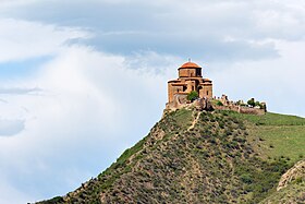 Jvari monastery | |
 Flag  Seal | |
 Location of the municipality within Georgia | |
| Country | |
| Region | Mtskheta-Mtianeti |
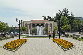
| Administrative centre | Mtskheta |
| Government | |
| • Body | Mtskheta Municipal Assembly |
| • Mayor | Giorgi Kapanadze [1] |
| Area | |
| • Total | 668 km2 (258 sq mi) |
| Population (2014) | |
| • Total | 55,651 |
| • Density | 69.05/km2 (178.8/sq mi) |
| Population by ethnicity[2] | |
| • Georgians | 92,04 % |
| • Azerbaijanis | 4,15 % |
| • Ossetians | 1,23 % |
| • Armenians | 0,47 % |
| • Russians | 0,35 % |
| Time zone | UTC+4 (Georgian Standard Time) |
| Website | http://mtskheta.gov.ge/ka/home |
This article needs additional citations for verification. (June 2012) |
Mtskheta (Georgian: მცხეთის მუნიციპალიტეტი) is a district of Georgia, in the region of Mtskheta-Mtianeti. Its main town is Mtskheta.[citation needed] Population of Mtskheta Municipality - 47 711 inhabitants. The municipality includes one city (Mtskheta) and 63 settlements. The city is the municipal center of Mtskheta and its population is 7,940 inhabitants, or 13% of the population of the municipality. The largest village is Mukhrani with 7 735 inhabitants.
Geography and climate[]

Mtskheta Municipality is located in Mtskheta-Mtianeti region of eastern Georgia. Its administrative center is the city of Mtskheta. The municipality is bordered by Sagarejo Municipality to the east, Kaspi Municipality to the west, Dusheti and Tianeti to the north, Gardabani and Tetritskaro municipalities and also Tbilisi to the south. The region is characterized by a variety of natural conditions. The territory of Mtskheta is a low and mid-mountain region. In its southern part the Saguramo Ridge is carved, to the south-east is raised the Satskepela Ridge. Its eastern end is called the Armazi Range, which is 1125 m high. There is a hillock of Skhaltbi between the rivers Ksani and Aragvi.
One of the main morphological elements of the municipality is the plain of Mukhrani-Saguramo. The Mtkvari River flows on the territory of the district, the main tributaries of which are: Khekordzula, Aragvi and Dighmistskali. There are also lakes in the region. Mtskheta is distinguished by its diversity of flora and fauna. Saguramo Nature Reserve includes Caucasian deer, Capreolus, brown bear, wolf, fox, lynx, rabbit, otter and more. There is moderately humid subtropical climate in Mtskheta municipality. There is moderately humid climate with hot summers and cold winters on Mukhrani-Saguramo plain. Average annual air temperature is 10.8 ° C and -1.1 ° C in January. On the ridges of Skhaltbi and Saguramo, there are mild cold winters and long warm summers. [3]
History[]
The area was still inhabited during the Bronze Age, as indicated by the settlements of Samtavro, Tsitsamuri, Narekvavi and other settlements. From the beginning of the I millennium BC, the great shifts characteristic of the life of the largest political entity in the East have also reflected on the history of Mtskheta. The strong cultural invasion of Mtskheta significantly affected the life of the city until the III - IV centuries. According to legend, the city was founded by the ethnarch Mtskhetos. From the end of the IV century BC Mtskheta was the political center of the newly created Kartli (Iberian) kingdom. According to legend, Nino, a missionary from Jerusalem, preached Christianity in Mtskheta at the beginning of the IV century. In 326, Mirian III adopted a new religion and Christianity became the state religion. According to legend, by the prayer of St. Nino hurricanes and hail broke out and crushed Armazian idols.
At the beginning of the VI century Dachi Ujarmeli moved the capital from Mtskheta to Tbilisi. Mtskheta has lost its political significance, though it has remained a religious center. In the early medieval period, there was an active rebuilding of cult buildings in the city. Samtavro, Jvari, Antioch and more were built during this period. In 736-738, the Arab Commander-Marwan the deaf raided the city and destroyed Armazi Fortress. At the beginning of the XV century it was destroyed by Temur lang. The importance of Mtskheta gradually diminished and after the accession of the Kingdom of Kartli to Russia, it was a small village in the Dusheti Mazra. Mtskheta became a separate district in 1930-34, today it has the status of a city and a municipality. [4]
Politics[]
Mtskheta Municipal Assembly (Georgian: მცხეთის საკრებულო) is a representative body in Mtskheta Municipality. currently consisting of 29 members. The council is assembles into session regularly, to consider subject matters such as code changes, utilities, taxes, city budget, oversight of city government and more. Mtskheta sakrebulo is elected every four year. The last election was held in October 2017. [5]
| Party | Seats | Current Municipal Assembly | |||||||||||||||||||||||
|---|---|---|---|---|---|---|---|---|---|---|---|---|---|---|---|---|---|---|---|---|---|---|---|---|---|
| Georgian Dream | 23 | ||||||||||||||||||||||||
| UNM | 2 | ||||||||||||||||||||||||
| Alliance of Patriots | 2 | ||||||||||||||||||||||||
| European Georgia | 1 | ||||||||||||||||||||||||
| Labour Party | 1 | ||||||||||||||||||||||||
Cultural monuments[]


- Svetitskhoveli
- Jvari Monastery
- Samtavro Monastery
- Ksani fortress
- Armazi Settlement
- Shio-mghvime Monastery Complex
- Pompey bridge
- Armazi St.Mary's Church
- Armazistsikhe-Bagineti
Demography[]
| Year | Population |
|---|---|
| 1989 | 63,123 |
| 2002 | 65,248 |
| 2014 | 47,711 |
| 2018 | 53,900 |
Villages of Mtskheta Municipality[]
- Arashenda,
- Agdgomliantkari,
- Akhaldaba,
- Akhali Nichbisi,
- Akhalsopeli,
- Akhalubani,
- Bevreti,
- Bitsmendi,
- Buriani,
- Galavani,
- Gorovani,
- Ereda,
- Vaziani,
- Vardisubani,
- Zakaro,
- Zemo Nichbisi,
- Tezami,
- Karsanobi,
- Lelubani,
- Lisi,
- Mamkoda,
- Misaktsieli,
- Mskhaldidi,
- Mukhatgverdi,
- Mukhattskaro,
- Mukhrani,
- Mshralkhevi,
- Navdaraantkari,
- Navazi,
- Natakhtari,
- Patara Kanda,
- Saguramo,
- Satovle,
- Saskhori,
- Skhaltba,
- Tabaruki,
- Kupurisi,
- Kvebrisi,
- Krevisri,
- Shankevani,
- Chardakhi,
- Tsikhisdziri,
- Tskhvarichamia,
- Dzalantkhevi,
- Dzalisi,
- Dzegvi,
- Old Kanda,
- Tserovani,
- Tsilkani,
- Tsinamdzgviantkari,
- Tsitsamuri,
- Tsodoreti,
- Chilaantkari,
- Khekordzi,
- Jighaura
See also[]
References[]
External links[]
- Districts of Georgia, Statoids.com
Coordinates: 41°51′00″N 44°43′00″E / 41.8500°N 44.7167°E

This Georgia location article is a stub. You can help Wikipedia by . |
- Municipalities of Mtskheta-Mtianeti
- Georgia (country) geography stubs