Zugdidi Municipality
Zugdidi Municipality | |
|---|---|
 | |
 Flag  Seal | |
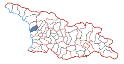 Location of the municipality within Georgia | |
| Country | |
| Region | Samegrelo |
| Administrative centre | Zugdidi |
| Government | |
| • Body | Zugdidi Municipal Assembly |
| • Mayor | Giorgi (Gega) Shengelia [1] |
| Area | |
| • Total | 668 km2 (258 sq mi) |
| Population (2014) | |
| • Total | 62 511 |
| • Density | 9,358/km2 (24,240/sq mi) |
| Population by ethnicity[2] | |
| • Georgians | 99,73 % |
| • Russians | 0,17 % |
| • Ukrainians | 0,06 % |
| Time zone | UTC+4 (Georgian Standard Time) |
| Website | http://zugdidi.mun.gov.ge/ge |
Zugdidi (Georgian: ზუგდიდის მუნიციპალიტეტი) is a Municipality of Georgia, in the region of Samegrelo-Zemo Svaneti. Zugdidi Municipality is located in the central part of western Georgia (area -692 sq. Km), its western border follows the Black Sea coast (Ganmukhuri, Anaklia), the administrative strip of Abkhazia (Gali district) in the northwest, Tsalenjikha Municipality in the north and northeast, It borders Chkhorotsqu Municipality and Khobi Municipality to the south. Zugdidi is the administrative center of both Zugdidi Municipality and Samegrelo Zemo-Svaneti region.
History[]
Ancient History[]

The territory of Zugdidi municipality, due to its economic-geographical location, seems to have been inhabited since ancient times. Archaeological sites confirm that coastal wetlands originated in the recent geological past. It can be seen that during the flourishing of the Colchis culture in the fourth-third millennia of the old year the wetlands were significantly less.
During the Hellenistic period, an important trade route passed through the territory of modern Zugdidi municipality from Svaneti, on the river. Along the Enguri stream, in the direction of the Black Sea and from there, trade goods were transported to the Hellenic world (direct evidence of the development of this trade route must be the ancient necropolis of the village Riki, with the tombs of socially advanced members), which is confirmed by numismatic materials.
Until the second half of the nineteenth century, Abkhazia and Samegrelo Imereti of the Enguri region were connected with the so-called "Through Middle Samegrelo". This road passed through Bedia to the foothills and the village. The river crossed the Dikhazurga. Enguri then went directly to the village. Towards Chakvinji, through the territories of modern Chkhorotsku and Martvili municipalities, directly in the direction of Khoni.
Zugdidi was an important city of ancient Georgia. Its etymology has been touched upon by many scholars, most of them suggest that Zugdidi // Zurgdidi // Zugdidi means a big hill in Megrelian. This was the name of the hill, which was later called Mantskhvarkarish Sukia (Hill of the Savior's Gate), after which the city built here took its name. [3]
Middle Ages up to early modern period[]
In written sources, Zugdidi is first mentioned by the narrator Beri Egnatashvili in 1572 in connection with the battle between Guria, the chief uncle of Guria, and George III, the chief of Principality of Mingrelia. In the first half of the 17th century, the chief of Samegrelo, Levan II Dadiani, made Zugdidi his capital city. During the reign of Levan II Dadiani (1634-1657), the Odisha principality was the strongest among the kingdoms of western Georgia. Zugdidi, as the capital of this principality, has become a very important city.
In order to develop trade in Zugdidi, in 1636 Levan II Dadiani deported the Chkhareli Armenian and Jewish merchants who had been taken to the ransom of King George Imereti. "We built the city of Chkhari, settled in Zugdidi and settled in Rukhi." Gray was considered a part of Zugdidi, so the construction of Gray Fortress should have started at this time, the main purpose of which was to protect the city.
After the death of Levan II Dadiani (1657), the merchants who moved to Zugdidi were returned by King Alexander of Imereti to Chkhari, which significantly undermined the commercial profitability of Zugdidi. Moreover, the second half of the 17th century and the first quarter of the 18th century turned western Georgia into an arena of incessant civil feudal wars and Ottoman Empire raids, and Zugdidi itself was plundered many times.
In 1662, King Vakhtang V of Kartli (1658–1675), enraged by the third Vamek III of Odisha, invaded Samegrelo and took Rukhi Fortress. This further weakened the princely state of Odisha. In the 70s of the 17th century, the attacks of Abkhazians on Samegrelo and especially on Zugdidi became more frequent, their Marbelian detachments razed everything to the ground, looted temples, and completely destroyed Chirnakhuli. Similarly, from the end of the 17th century until the whole of the 18th century, Zugdidi and its environs were the victims of permanent raids by the Turks, during which the "purchase of captives" reached unprecedented proportions.
At the end of 1779, a joint army of Abkhazians and Turks under the command of Zurab Shervashidze invaded Samegrelo. The second man of Samegrelo, II Dadiani, asked King Solomon of Imereti for help. The troops of all the flags of Imereti gathered in Bandza and the army was led by King Solomon himself. The enemy army, where there were 12,000 warriors divided into three divisions, crossed the river. Enguri and includes the united army of Imereti and Megrelians. The decisive battle took place near the Gray Fortress, in the Saralobegi Valley. The enemy army was severely defeated and western Georgia escaped another devastating invasion, the angry population of Mount Urta returned to their homes. This was the last expedition of the Abkhaz feudal lords against their ruler - the prince of Samegrelo. [4]
Geography and Climate[]

According to the scheme of tectonic zones, the territory of Zugdidi Municipality is included in the Kolkheti subzone of the western subsidence zone of the Georgian Belt. According to the geomorphological features, it consists of three parts: 1. Accumulated Odisha lowland with flat surface (west and south-western part of the municipality up to the Black Sea), 2. Sloping Vake-Odisha plateau (east and north-east part of the municipality and flooded rivers and With a network of gorges), 3. Foothills and Urta mountain (on the border of Khobi municipality, height 469 m.), The northern slope of which is located in the territory of Zugdidi municipality.
The whole territory of Zugdidi Municipality is located in the humid subtropical climate of the sea, the plain and hilly strip are characterized by humid warm climate, snowless winters and hot summers. The proximity of the Black Sea has a great influence on the nature of the climate. High radiation balance leads to a high thermal regime. The average perennial air temperature near the land surface is over 14 degrees. The coldest month is January, the temperature is positive in the plain part and at this time it is 6-7 degrees on average, while in the upper part it is negative. The warmest months are July and August, with average monthly temperatures exceeding 22 degrees. The average absolute maximum air temperature is 34-36 degrees in the Black Sea coast, up to 38 degrees in the plains. The humid air masses rising from the sea cause high air humidity throughout the year. The partial pressure of water vapor is high in the Black Sea zone.
The territory of Zugdidi municipality is characterized by high cloudiness and heavy rainfall, the total cloudiness varies in the range of 60-70% during the year, and the cloudiness of the lower tier reaches 40-35%. The maximum of cloudiness in the annual course is observed in late winter and early spring, and the minimum in autumn. Annual precipitation varies between 1400-3000 mm. Uneven terrestrial heating, the presence of mountainous terrain and the proximity of the relatively warm Black Sea lead to the formation of winds of different directions and strengths. East winds prevail in the cold season of the year, while west (sea) winds prevail in the warm season. The number of foggy days varies from 10 to 50, with an average of 30-40 thunderstorm days.
Agro-climatic conditions are very favorable for the creation of multidisciplinary and highly profitable agricultural production, especially for the development of such fields as mesimindeoba, mechaieoba, production of subtropical crops (citrus, laurel, kiwi, feijoa, etc.), fruit and berry production. Many of the water bodies in the territory of Zugdidi Municipality are rivers, swamps and springs, which have played an important role in the economic and traffic relations of the local population since time immemorial. Of the great rivers, the Enguri and the Jumi are distinguished.
The territory of Zugdidi Municipality, as part of the Kolkheti Botanical Province, includes the lowland and foothill forest areas, while the Silnar-sandy vegetation area of the Black Sea coast belongs to the Euclidean part of the Mediterranean region. The main types of vegetation in the lowland and foothill forest areas are forests, water and swamp vegetation. Most of the forest vegetation is represented by secondary types - deciduous forests and shrubs, the main forest formations in the lowlands and foothills - alder, oak, brush-oak and brush-wood, hornbeam, chestnut and wood. [5]
Politics[]

Zugdidi Municipal Assembly (Georgian: ზუგდიდის საკრებულო) is a representative body in Zugdidi Municipality currently consisting of 45 members. The council is assembles into session regularly, to consider subject matters such as code changes, utilities, taxes, city budget, oversight of city government and more. Zugdidi sakrebulo is elected every four year. The last election was held in October 2021.
| Party | Seats (45) | Current Municipal Assembly | |||||||||||||||||||||||||||||||||||||||||||||
|---|---|---|---|---|---|---|---|---|---|---|---|---|---|---|---|---|---|---|---|---|---|---|---|---|---|---|---|---|---|---|---|---|---|---|---|---|---|---|---|---|---|---|---|---|---|---|---|
| UNM | 22 | ||||||||||||||||||||||||||||||||||||||||||||||
| GD | 20 | ||||||||||||||||||||||||||||||||||||||||||||||
| FG | 3 | ||||||||||||||||||||||||||||||||||||||||||||||
City Assembly 2017-2021[]
| Party | Seats (50) | Municipal Assembly 2017-2021 | |||||||||||||||||||||||||||||||||||||||||||||
|---|---|---|---|---|---|---|---|---|---|---|---|---|---|---|---|---|---|---|---|---|---|---|---|---|---|---|---|---|---|---|---|---|---|---|---|---|---|---|---|---|---|---|---|---|---|---|---|
| GD | 43 | ||||||||||||||||||||||||||||||||||||||||||||||
| UNM | 5 | ||||||||||||||||||||||||||||||||||||||||||||||
| EG | 2 | ||||||||||||||||||||||||||||||||||||||||||||||
Population of Zugdidi[]

City - 2 (Zugdidi and Anaklia)
Village - 48
Distance between the administrative center and Tbilisi - 339 km.
National composition of the population :
1. Georgian - 98.2%;
2. Russian - 0.9%;
3. Ukrainian - 0.1%;
4. Abkhazian - 0.1%.
5. Other balance - 0.6%
There are many villages in Zugdidi Municipality, there are: , , Narazeni, , , Rukhi, , , , Jikhashkari, , , , Bashi, , , , , Ganmukhuri, , , , , , , , , Ingiri, , Anaklia, , , , , , , .
Historical sites[]
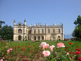
- Dadiani Palace
- Chakvinji fortress
- Tsaishi cathedral
- Kolkheti National Park
- Zugdidi Botanical Garden
- Rukhi Fortress
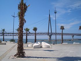
- Anaklia Fortress
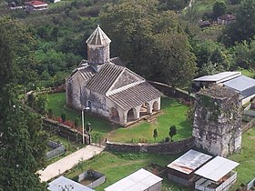
- Church of St. George in Tkaia
Gallery[]
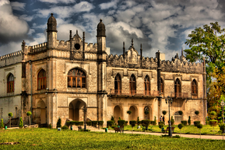
Dadiani Palace
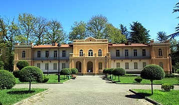
Dadiani Summer Palace

Tkaia church


See also[]
- Districts of Georgia (country)
References[]
- ^ "მერი - ზუგდიდის მუნიციპალიტეტი" (in Georgian). Zugdidi.mun.gov.ge. Retrieved 2021-06-19.
- ^ "Ethnic composition of Georgia 2014". Pop-stat.mashke.org. Retrieved 2021-06-19.
- ^ http://zugdidi.mun.gov.ge/ge/zugdidis-municipalitetis-istoria
- ^ http://zugdidi.mun.gov.ge/ge/zugdidis-municipalitetis-istoria
- ^ http://zugdidi.mun.gov.ge/ge/mdebareoba-ganlageba-municipaluri-centri
External links[]
- Districts of Georgia, Statoids.com
Coordinates: 42°30′00″N 41°51′00″E / 42.5000°N 41.8500°E

This Georgia location article is a stub. You can help Wikipedia by . |
- Municipalities of Samegrelo-Zemo Svaneti
- Georgia (country) geography stubs