[3] Name on the Register
Image
Date listed[4]
Location
City or town
Description
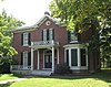
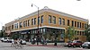
1
Ballenger Building
January 21, 2004 (#03001474 ) 27-29 South Ninth St. 38°57′02″N 92°19′40″W / 38.950556°N 92.327778°W / 38.950556; -92.327778 (Ballenger Building ) Columbia
2
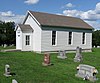
Bond's Chapel Methodist Episcopal Church
September 9, 1993 (#93000940 ) MO A, 2.5 miles (4.0 km) northeast of Hartsburg 38°42′34″N 92°17′08″W / 38.709336°N 92.285449°W / 38.709336; -92.285449 (Bond's Chapel Methodist Episcopal Church ) Hartsburg
3
John W. Boone House
September 4, 1980 (#80002309 ) 4th St. between E. Broadway and Walnut 38°57′08″N 92°19′57″W / 38.952222°N 92.3325°W / 38.952222; -92.3325 (John W. Boone House ) Columbia
4
Central Dairy Building
January 20, 2005 (#04001519 ) 1104-1106 East Broadway 38°57′05″N 92°19′30″W / 38.951283°N 92.325014°W / 38.951283; -92.325014 (Central Dairy Building ) Columbia
5
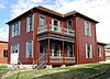
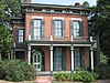
Albert Bishop Chance House and Gardens
July 3, 1979 (#79001345 ) 319 E. Sneed St. 39°12′36″N 92°08′04″W / 39.21°N 92.134444°W / 39.21; -92.134444 (Albert Bishop Chance House and Gardens ) Centralia
6
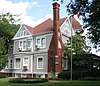
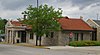
Chatol
April 20, 1979 (#79001346 ) 543 S. Jefferson St. 39°12′17″N 92°08′06″W / 39.204722°N 92.135°W / 39.204722; -92.135 (Chatol ) Centralia
7
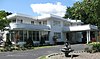
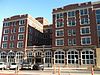
Coca-Cola Bottling Company Building
February 14, 2006 (#06000043 ) 10 Hitt St. 38°57′03″N 92°19′30″W / 38.950833°N 92.325°W / 38.950833; -92.325 (Coca-Cola Bottling Company Building ) Columbia
8
Columbia Cemetery
February 1, 2007 (#06001335 ) 30 East Broadway 38°56′56″N 92°20′13″W / 38.948889°N 92.336944°W / 38.948889; -92.336944 (Columbia Cemetery ) Columbia
9
Columbia National Guard Armory
March 25, 1993 (#93000197 ) 701 E. Ash St. 38°57′14″N 92°19′45″W / 38.953889°N 92.329167°W / 38.953889; -92.329167 (Columbia National Guard Armory ) Columbia
10
Sanford F. Conley House
December 18, 1973 (#73001035 ) 602 Sanford Pl. 38°56′39″N 92°19′52″W / 38.944167°N 92.331111°W / 38.944167; -92.331111 (Sanford F. Conley House ) Columbia
11
Fred Douglass School
September 4, 1980 (#80002310 ) 310 N. Providence Rd. 38°57′18″N 92°19′59″W / 38.955°N 92.333056°W / 38.955; -92.333056 (Fred Douglass School ) Columbia
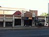
12
Downtown Columbia Historic District
November 8, 2006 (#06000990 ) Parts of 7th, 8th, 9th, 10th, E. Broadway, Cherry, Hitt, Locust, and E. Walnut Sts.; also 1019, 1020, 1023, and 1025-33 E. Walnut St. 38°57′05″N 92°19′39″W / 38.951502°N 92.327573°W / 38.951502; -92.327573 (Downtown Columbia Historic District ) Columbia Addresses along E. Walnut St. represent a boundary increase of May 8, 2008
13
East Campus Neighborhood Historic District
February 16, 1996 (#96000019 ) Roughly bounded by Bouchelle, College, University and High Sts. including parts of Willis, Bass, Dorsey and Anthony Sts. 38°56′44″N 92°19′07″W / 38.945556°N 92.318611°W / 38.945556; -92.318611 (East Campus Neighborhood Historic District ) Columbia
14
Eighth and Broadway Historic District
April 22, 2003 (#03000298 ) 800-810 E. Broadway Blvd. 38°57′04″N 92°19′42″W / 38.951111°N 92.328333°W / 38.951111; -92.328333 (Eighth and Broadway Historic District ) Columbia The contributing properties include the Miller Building, Matthews Hardware, and Metropolitan Building.
15
Samuel H. and Isabel Smith Elkins House
September 12, 1996 (#96001012 ) 315 N. 10th St. 38°57′20″N 92°19′36″W / 38.955556°N 92.326667°W / 38.955556; -92.326667 (Samuel H. and Isabel Smith Elkins House ) Columbia
16
First Christian Church
October 29, 1991 (#91001590 ) 101 N. Tenth St. 38°57′10″N 92°19′36″W / 38.952778°N 92.326667°W / 38.952778; -92.326667 (First Christian Church ) Columbia
17
Francis Quadrangle Historic District
December 18, 1973 (#73001036 ) Bounded by Conley Ave. and Elm, 6th, and 9th Sts. 38°56′46″N 92°19′44″W / 38.946111°N 92.328889°W / 38.946111; -92.328889 (Francis Quadrangle Historic District ) Columbia
18
Frederick Apartments
April 16, 2013 (#13000172 ) 1001 University Avenue 38°56′48″N 92°19′34″W / 38.946767°N 92.326186°W / 38.946767; -92.326186 (Frederick Apartments ) Columbia
19
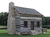
David Gordon House and Collins Log Cabin
August 29, 1983 (#83000972 ) 2100 E. Broadway 38°54′24″N 92°17′41″W / 38.906532°N 92.294647°W / 38.906532; -92.294647 (David Gordon House and Collins Log Cabin ) Columbia
20
Gordon Tract Archeological Site
March 16, 1972 (#72000705 ) Address Restricted Columbia
21
Greenwood
January 15, 1979 (#79001347 ) 3005 Mexico Gravel Rd. 38°58′47″N 92°17′32″W / 38.979722°N 92.292222°W / 38.979722; -92.292222 (Greenwood ) Columbia
22
David Guitar House
September 9, 1993 (#93000939 ) 2815 Oakland Gravel Rd. 38°58′47″N 92°18′16″W / 38.979722°N 92.304444°W / 38.979722; -92.304444 (David Guitar House ) Columbia
23
Samuel E. Hackman Building
December 10, 1998 (#98001501 ) 30 S. Second St. 38°41′41″N 92°18′31″W / 38.694722°N 92.308611°W / 38.694722; -92.308611 (Samuel E. Hackman Building ) Hartsburg
24
Hamilton-Brown Shoe Factory
July 19, 2002 (#02000791 ) 1123 Wilkes Blvd. 38°57′38″N 92°19′22″W / 38.960556°N 92.322778°W / 38.960556; -92.322778 (Hamilton-Brown Shoe Factory ) Columbia
25
Harrisburg School--Ancient Landmark Masonic Lodge Number 356 A.F. & A.M.
December 24, 2013 (#13000970 ) 140 S. Harris St. 39°08′28″N 92°27′43″W / 39.141178°N 92.461866°W / 39.141178; -92.461866 (Harrisburg School--Ancient Landmark Masonic Lodge Number 356 A.F. & A.M. ) Harrisburg
26
William B. Hunt House
January 9, 1997 (#96001567 ) 8939 W. Terrapin Hills Rd. 38°55′09″N 92°28′27″W / 38.919167°N 92.474167°W / 38.919167; -92.474167 (William B. Hunt House ) Columbia
27
Kress Building
March 9, 2005 (#05000122 ) 1025 E. Broadway 38°57′07″N 92°19′32″W / 38.951944°N 92.325556°W / 38.951944; -92.325556 (Kress Building ) Columbia
28
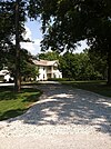
Maplewood
April 13, 1979 (#79001348 ) Nifong Blvd. and Ponderosa Dr. 38°54′29″N 92°17′43″W / 38.908056°N 92.295278°W / 38.908056; -92.295278 (Maplewood ) Columbia
29
McCain Furniture Store
August 17, 2005 (#05000890 ) 916 E. Walnut 38°57′09″N 92°19′37″W / 38.952407°N 92.326924°W / 38.952407; -92.326924 (McCain Furniture Store ) Columbia
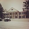
30
Missouri State Teachers Association Building
September 4, 1980 (#80002311 ) 407 S. 6th St. 38°56′50″N 92°19′53″W / 38.947173°N 92.331314°W / 38.947173; -92.331314 (Missouri State Teachers Association Building ) Columbia
31
Missouri Theater
June 6, 1979 (#79001349 ) 201-215 S. 9th St. 38°56′57″N 92°19′39″W / 38.949167°N 92.3275°W / 38.949167; -92.3275 (Missouri Theater ) Columbia
32
Missouri United Methodist Church
September 4, 1980 (#80002312 ) 204 S. 9th St. 38°56′57″N 92°19′37″W / 38.949167°N 92.326944°W / 38.949167; -92.326944 (Missouri United Methodist Church ) Columbia
33
Missouri, Kansas, and Texas Railroad Depot
January 29, 1979 (#79001350 ) 402 E. Broadway 38°57′05″N 92°19′58″W / 38.951306°N 92.332706°W / 38.951306; -92.332706 (Missouri, Kansas, and Texas Railroad Depot ) Columbia
34
Mount Zion Church and Cemetery
January 14, 2013 (#12001177 ) 11070 Mount Zion Rd. 39°04′09″N 92°10′44″W / 39.069286°N 92.178936°W / 39.069286; -92.178936 (Mount Zion Church and Cemetery ) Hallsville
35
North Ninth Street Historic District
January 21, 2004 (#03001473 ) 5-36 North Ninth St. 38°57′07″N 92°19′39″W / 38.951944°N 92.3275°W / 38.951944; -92.3275 (North Ninth Street Historic District ) Columbia
36
Moses U. Payne House
October 7, 1994 (#94001204 ) 201 N. Roby Farm Rd. 38°57′45″N 92°31′53″W / 38.9625°N 92.531389°W / 38.9625; -92.531389 (Moses U. Payne House ) Rocheport
37
Pierce Pennant Motor Hotel
September 2, 1982 (#82003125 ) 1406 Old US 40W 38°58′02″N 92°21′32″W / 38.967222°N 92.358889°W / 38.967222; -92.358889 (Pierce Pennant Motor Hotel ) Columbia
38
Rocheport
October 8, 1976 (#76001108 ) MO 240 38°58′43″N 92°33′49″W / 38.978611°N 92.563611°W / 38.978611; -92.563611 (Rocheport ) Rocheport
39
St. Paul A.M.E. Church
September 4, 1980 (#80002315 ) 5th and Park Sts. 38°57′17″N 92°19′54″W / 38.954801°N 92.331561°W / 38.954801; -92.331561 (St. Paul A.M.E. Church ) Columbia
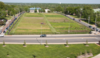
40
Sanborn Field and Soil Erosion Plots
October 15, 1966 (#66000413 ) University of Missouri campus 38°56′33″N 92°19′14″W / 38.942563°N 92.320488°W / 38.942563; -92.320488 (Sanborn Field and Soil Erosion Plots ) Columbia
41
Second Baptist Church
September 4, 1980 (#80002313 ) 4th St. and Broadway 38°57′07″N 92°19′58″W / 38.951944°N 92.332778°W / 38.951944; -92.332778 (Second Baptist Church ) Columbia
42
Second Christian Church
September 4, 1980 (#80002314 ) 401 N. 5th 38°57′20″N 92°19′55″W / 38.955548°N 92.332006°W / 38.955548; -92.332006 (Second Christian Church ) Columbia
43
Senior Hall
August 2, 1977 (#77000799 ) Stephens College campus 38°57′01″N 92°19′23″W / 38.950278°N 92.323056°W / 38.950278; -92.323056 (Senior Hall ) Columbia
44
Sigma Alpha Epsilon Building
October 20, 2014 (#14000870 ) 24 E. Stewart Rd. 38°56′47″N 92°20′12″W / 38.9463°N 92.3368°W / 38.9463; -92.3368 (Sigma Alpha Epsilon Building ) Columbia
45
Stephens College South Campus Historic District
November 25, 2005 (#05001326 ) 1200 E. Broadway 38°57′03″N 92°19′22″W / 38.950782°N 92.322825°W / 38.950782; -92.322825 (Stephens College South Campus Historic District ) Columbia
46
John N. and Elizabeth Taylor House
May 25, 2001 (#01000546 ) 716 W Broadway 38°57′04″N 92°20′57″W / 38.951111°N 92.349167°W / 38.951111; -92.349167 (John N. and Elizabeth Taylor House ) Columbia
47
Tiger Hotel
February 29, 1980 (#80002316 ) 23 S. 8th St. 38°57′03″N 92°19′44″W / 38.950851°N 92.328831°W / 38.950851; -92.328831 (Tiger Hotel ) Columbia
48
Virginia Building
March 13, 2002 (#02000163 ) 111 S. Ninth St. 38°57′01″N 92°19′40″W / 38.950278°N 92.327778°W / 38.950278; -92.327778 (Virginia Building ) Columbia
49
Wabash Railroad Station and Freight House
October 11, 1979 (#79001351 ) 126 N. 10th St. 38°57′12″N 92°19′34″W / 38.953333°N 92.326111°W / 38.953333; -92.326111 (Wabash Railroad Station and Freight House ) Columbia
50
West Broadway Historic District
April 27, 2010 (#10000221 ) 300-922 W. Broadway (except 800, 808, 812) 38°57′06″N 92°20′51″W / 38.951669°N 92.347481°W / 38.951669; -92.347481 (West Broadway Historic District ) Columbia
51
Wright Brothers Mule Barn
November 1, 2007 (#07001119 ) 1101-1107 Hinkson Ave. & 501-507 Fay St. 38°57′26″N 92°19′22″W / 38.957222°N 92.322778°W / 38.957222; -92.322778 (Wright Brothers Mule Barn ) Columbia