[3] Name on the Register
Image
Date listed[4]
Location
City or town
Description
1
Anderson House and Lexington Battlefield
June 4, 1969 (#69000110 ) Roughly bounded by 10th, 15th, Utah and Wood Sts., and Missouri Pacific RR 39°11′34″N 93°52′46″W / 39.192778°N 93.879444°W / 39.192778; -93.879444 (Anderson House and Lexington Battlefield ) Lexington
2
Napoleon Buck House Upload image November 14, 1997 (#97001431 ) 0.40 mi. S of jct. of US 24 and MO 273 39°11′49″N 93°32′09″W / 39.196944°N 93.535833°W / 39.196944; -93.535833 (Napoleon Buck House ) Waverly No longer in existence
3
Minatree Catron House Upload image November 14, 1997 (#97001432 ) 0.1 mi W of jct. of US 24 and MO 110 39°10′49″N 93°47′55″W / 39.180278°N 93.798611°W / 39.180278; -93.798611 (Minatree Catron House ) Lexington
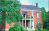
4
John E. Cheatham House Upload image July 8, 1993 (#93000550 ) 739 MO 13 39°10′21″N 93°52′45″W / 39.1725°N 93.879167°W / 39.1725; -93.879167 (John E. Cheatham House ) Lexington
5
Chicago and Alton Railroad Depot at Higginsville Upload image March 25, 1987 (#87000451 ) 2109 Main St. 39°04′25″N 93°43′00″W / 39.073520°N 93.71678°W / 39.073520; -93.71678 (Chicago and Alton Railroad Depot at Higginsville ) Higginsville
6
Commercial Community Historic District Upload image August 4, 1983 (#83001025 ) Roughly bounded by 8th, 13th, South, Broadway, and Main Sts. 39°11′09″N 93°52′52″W / 39.185833°N 93.881111°W / 39.185833; -93.881111 (Commercial Community Historic District ) Lexington
7
Confederate Chapel, Cemetery and Cottage Upload image December 16, 1981 (#81000335 ) N of Higginsville 39°05′54″N 93°43′45″W / 39.098333°N 93.729167°W / 39.098333; -93.729167 (Confederate Chapel, Cemetery and Cottage ) Higginsville
8
Cumberland Presbyterian Church
November 14, 1978 (#78001665 ) 112 S. 13th St. 39°11′06″N 93°52′45″W / 39.185°N 93.879167°W / 39.185; -93.879167 (Cumberland Presbyterian Church ) Lexington
9
James M. Dinwiddie House Upload image November 14, 1997 (#97001430 ) 0.25 mi. E of jct. of US 24 and MO 184 39°11′32″N 93°42′06″W / 39.192222°N 93.701667°W / 39.192222; -93.701667 (James M. Dinwiddie House ) Dover
10
Theodore Gosewisch House
November 14, 1997 (#97001433 ) 0.5 mi. W of jct. of MO 13 and Marshall School Rd. 39°09′28″N 93°53′30″W / 39.157778°N 93.891667°W / 39.157778; -93.891667 (Theodore Gosewisch House ) Lexington
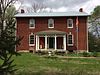
11
Alexander and Elizabeth Aull Graves House Upload image July 8, 1993 (#93000552 ) 2326 Aull Ln. 39°10′32″N 93°51′56″W / 39.175556°N 93.865556°W / 39.175556; -93.865556 (Alexander and Elizabeth Aull Graves House ) Lexington No longer in existence
12
Hicklin Hearthstone Upload image December 28, 1982 (#82000585 ) E of Lexington on US 24 39°11′10″N 93°49′44″W / 39.186111°N 93.828889°W / 39.186111; -93.828889 (Hicklin Hearthstone ) Lexington
13
Hicklin School Upload image February 24, 2004 (#04000088 ) MO 24 39°11′05″N 93°49′29″W / 39.184722°N 93.824722°W / 39.184722; -93.824722 (Hicklin School ) Lexington
14
Highland Avenue Historic District
August 4, 1983 (#83001026 ) Roughly bounded by Highland Ave. from Rock to Bluff Sts. 39°11′04″N 93°52′30″W / 39.184444°N 93.875°W / 39.184444; -93.875 (Highland Avenue Historic District ) Lexington
15
House at 1413 Lafayette St. Upload image March 25, 1999 (#99000379 ) 1413 Lafayette St. 39°11′13″N 93°52′39″W / 39.186944°N 93.8775°W / 39.186944; -93.8775 (House at 1413 Lafayette St. ) Lexington
16
Houx-Hoefer-Rehkop House Upload image March 29, 1983 (#83001027 ) 1900 Walnut St. 39°04′33″N 93°43′07″W / 39.075833°N 93.718611°W / 39.075833; -93.718611 (Houx-Hoefer-Rehkop House ) Higginsville
17
David John House Upload image July 8, 1993 (#93000553 ) 103 S. 23rd St. 39°11′06″N 93°51′23″W / 39.185°N 93.856389°W / 39.185; -93.856389 (David John House ) Lexington No longer in existence
18
George Johnson House Upload image July 8, 1993 (#93000554 ) 102 S. 30th St. 39°11′07″N 93°51′16″W / 39.185278°N 93.854444°W / 39.185278; -93.854444 (George Johnson House ) Lexington
19
Lafayette County Courthouse
September 22, 1970 (#70000339 ) Public Sq. 39°11′06″N 93°52′49″W / 39.185°N 93.880278°W / 39.185; -93.880278 (Lafayette County Courthouse ) Lexington
20
Linwood Lawn Upload image April 23, 1973 (#73001044 ) SE of Lexington off U.S. 24 39°09′55″N 93°50′54″W / 39.165278°N 93.848333°W / 39.165278; -93.848333 (Linwood Lawn ) Lexington
21
Odessa Ice Cream Company Building
October 3, 1996 (#96001065 ) 101 W. Dryden St. 38°59′36″N 93°57′15″W / 38.993333°N 93.954167°W / 38.993333; -93.954167 (Odessa Ice Cream Company Building ) Odessa
22
Old Neighborhoods Historic District
August 4, 1983 (#83001028 ) Roughly bounded by 13th, 22nd, South Sts., Forest and Washington Aves. 39°11′08″N 93°52′28″W / 39.185556°N 93.874444°W / 39.185556; -93.874444 (Old Neighborhoods Historic District ) Lexington
23
William P. Robinson House Upload image November 14, 1997 (#97001428 ) ).2 mi. E and 0.15 mi. S of jct. of MO 107 and MO 112 39°09′41″N 93°50′24″W / 39.161389°N 93.84°W / 39.161389; -93.84 (William P. Robinson House ) Lexington
24
Thomas Shelby House Upload image November 14, 1997 (#97001429 ) 0.25 mi. E of US 24 and MO 111 39°10′47″N 93°47′09��W / 39.179722°N 93.785833°W / 39.179722; -93.785833 (Thomas Shelby House ) Lexington Demolished(?)
25
Spratt-Allen-Aull House Upload image July 8, 1993 (#93000555 ) 2321 Aull Ln. 39°10′30″N 93°51′57″W / 39.175°N 93.865833°W / 39.175; -93.865833 (Spratt-Allen-Aull House ) Lexington
26
Thomas Talbot and Rebecca Walton Smithers Stramcke House Upload image September 29, 1999 (#99001208 ) 15834 Highway O 39°08′24″N 93°52′57″W / 39.14°N 93.8825°W / 39.14; -93.8825 (Thomas Talbot and Rebecca Walton Smithers Stramcke House ) Lexington
27
D. W. B. and Julia Waddell Tevis House Upload image July 8, 1993 (#93000556 ) 505 S. 13th St. 39°10′43″N 93°52′43″W / 39.178611°N 93.878611°W / 39.178611; -93.878611 (D. W. B. and Julia Waddell Tevis House ) Lexington
28
Waddell House
October 11, 1979 (#79001378 ) 1704 South St. 39°11′02″N 93°52′29″W / 39.183889°N 93.874722°W / 39.183889; -93.874722 (Waddell House ) Lexington
29
Wentworth Military Academy
November 24, 1980 (#80002373 ) Washington Ave. and 18th St. 39°11′14″N 93°52′22″W / 39.187222°N 93.872778°W / 39.187222; -93.872778 (Wentworth Military Academy ) Lexington