National Register of Historic Places listings in Jefferson County, Missouri

Location of Jefferson County in Missouri
This is a list of the National Register of Historic Places listings in Jefferson County, Missouri.
This is intended to be a complete list of the properties and districts on the National Register of Historic Places in Jefferson County, Missouri, United States. Latitude and longitude coordinates are provided for many National Register properties and districts; these locations may be seen together in a map.[1]
There are 14 properties and districts listed on the National Register in the county.
- This National Park Service list is complete through NPS recent listings posted January 28, 2022.[2]
Current listings[]
| [3] | Name on the Register | Image | Date listed[4] | Location | City or town | Description |
|---|---|---|---|---|---|---|
| 1 | Beaumont-Tyson Quarry District | October 10, 1974 (#74001079) |
Address restricted[5] | Times Beach | 212 acres (86 ha) area which extends also into St. Louis County[6] | |
| 2 | October 1, 1974 (#74001075) |
Address Restricted | Byrnes Mill | |||
| 3 | October 1, 1974 (#74001080) |
Address Restricted | Times Beach | |||
| 4 | Central School Campus |  |
October 8, 2009 (#09000813) |
221 S. 3rd St. 38°08′18″N 90°33′23″W / 38.138292°N 90.556497°W | De Soto | |
| 5 | Thomas C. Fletcher House |  |
November 19, 1974 (#74001076) |
Elm between 1st and 2nd Sts. 38°13′55″N 90°34′02″W / 38.231944°N 90.567222°W | Hillsboro | |
| 6 | Gustave Greystone-Meissner House |  |
December 31, 1974 (#74001078) |
Northeast of Pevely off U.S. Route 61 38°18′13″N 90°22′48″W / 38.303611°N 90.38°W | Pevely | |
| 7 | Kimmswick Bone Bed |  |
November 5, 1980 (#80002371) |
Junction of Rock and Little Rock Creeks[7]: 41 38°22′45″N 90°23′01″W / 38.379167°N 90.383611°W | Imperial | Also known as "Mastodon State Historic Site". |
| 8 | Kimmswick Historic District |  |
July 24, 2007 (#07000752) |
Roughly bounded by Front St., 4th St., Mill St., Elm St., and Oak St. 38°22′00″N 90°21′51″W / 38.366606°N 90.364153°W | Kimmswick | |
| 9 | Valentine Leight General Store | 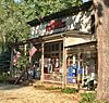 |
August 18, 1992 (#92001014) |
4566 Main St. 38°24′37″N 90°34′09″W / 38.410278°N 90.569167°W | House Springs | |
| 10 | October 16, 1974 (#74001077) |
Address Restricted | House Springs | |||
| 11 | Louis J. and Harriet Rozier House |  |
April 5, 2006 (#06000221) |
322 W. Clement 38°08′16″N 90°33′27″W / 38.137778°N 90.5575°W | DeSoto | |
| 12 | Sandy Creek Covered Bridge |  |
July 8, 1970 (#70000337) |
5 miles north of Hillsboro off U.S. Route 21 38°17′38″N 90°31′05″W / 38.293889°N 90.518056°W | Hillsboro | |
| 13 | Stonebrook |  |
January 14, 2011 (#10001130) |
3511 Stonebrook Forest Dr. 38°21′38″N 90°27′44″W / 38.360556°N 90.462222°W | Antonia | |
| 14 | Windsor Harbor Road Bridge | September 8, 1983 (#83001024) |
Windsor Harbor Rd. at Rock Creek 38°21′50″N 90°21′44″W / 38.363889°N 90.362222°W | Kimmswick |

See also[]
- List of National Historic Landmarks in Missouri
- National Register of Historic Places listings in Missouri
- Jefferson County Heritage and Historical Society of Missouri
References[]
| Wikimedia Commons has media related to National Register of Historic Places in Jefferson County, Missouri. |
- ^ The latitude and longitude information provided in this table was derived originally from the National Register Information System, which has been found to be fairly accurate for about 99% of listings. Some locations in this table may have been corrected to current GPS standards.
- ^ National Park Service, United States Department of the Interior, "National Register of Historic Places: Weekly List Actions", retrieved January 28, 2022.
- ^ Numbers represent an alphabetical ordering by significant words. Various colorings, defined here, differentiate National Historic Landmarks and historic districts from other NRHP buildings, structures, sites or objects.
- ^ The eight-digit number below each date is the number assigned to each location in the National Register Information System database, which can be viewed by clicking the number.
- ^ Federal and state laws and practices restrict general public access to information regarding the specific location of this resource. In some cases, this is to protect archeological sites from vandalism, while in other cases it is restricted at the request of the owner. See: Knoerl, John; Miller, Diane; Shrimpton, Rebecca H. (1990), Guidelines for Restricting Information about Historic and Prehistoric Resources, National Register Bulletin, National Park Service, U.S. Department of the Interior, OCLC 20706997.
- ^ "National Register Information System". National Register of Historic Places. National Park Service. November 2, 2013.
- ^ Adams, Robert McCormick. "The Kimmswick Bone Bed". Missouri Archaeologist 15.4 (1953): 40-56.

Municipalities and communities of Jefferson County, Missouri, United States | ||
|---|---|---|
County seat: Hillsboro | ||
| Cities |
|  |
| Villages | ||
| Townships | ||
| CDPs |
| |
| Other communities |
| |
| ||
Categories:
- Jefferson County, Missouri
- Lists of National Register of Historic Places in Missouri by county
- National Register of Historic Places in Jefferson County, Missouri