Newton County, Arkansas
Newton County | |
|---|---|
U.S. county | |
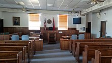
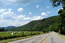
 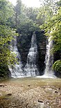    Clockwise from top: Boxley Valley, Hawksbill Crag, the Ozark Mountains in the Upper Buffalo Wilderness, Twin/Triple Falls at Camp Orr Boy Scout Camp, and the Newton County Courthouse in Jasper (center) | |
 Location within the U.S. state of Arkansas | |
 Arkansas's location within the U.S. | |
| Coordinates: 35°56′08″N 93°13′19″W / 35.935555555556°N 93.221944444444°W | |
| Country | |
| State | |
| Founded | December 14, 1842 |
| Named for | Thomas Willoughby Newton |
| Seat | Jasper |
| Largest city | Jasper |
| Area | |
| • Total | 823 sq mi (2,130 km2) |
| • Land | 821 sq mi (2,130 km2) |
| • Water | 2.3 sq mi (6 km2) 0.3%% |
| Population (2010) | |
| • Total | 8,330 |
| • Estimate (2019) | 7,753 |
| • Density | 10/sq mi (3.9/km2) |
| Time zone | UTC−6 (Central) |
| • Summer (DST) | UTC−5 (CDT) |
| Congressional districts | 3rd, 4th |

Newton County is a county in the U.S. state of Arkansas. As of the 2010 census, the population was 8,330.[1] The county seat is Jasper.[2] Newton County is Arkansas's 46th county, formed on December 14, 1842, and named for Thomas W. Newton, an Arkansas Congressman. It is an alcohol prohibition or dry county.
Newton County is part of the Harrison, AR Micropolitan Statistical Area.
History[]
Newton County residents were divided during the Civil War, serving in both the Confederate and Union armies. John Cecil, who had served as Newton County's sheriff, served as a Confederate Captain. Jasper blacksmith James R. Vanderpool (ca. 1832-1880) served as Captain of Union Company C, 1st Regiment Arkansas Infantry Volunteers, while farmer and teacher John McCoy (1820–1903) served as Captain of Union Company F, 1st Regiment Arkansas Infantry Volunteers. Many Newton County citizens served under each of these men, as well as in other units. As an example of how the war divided families, Confederate Captain Cecil's brother, Sam, served as a sergeant in Union Company D, 2nd Regiment Arkansas Cavalry Volunteers. Violence took a severe toll on the civilian population, and at one point, Captains McCoy and Vanderpool escorted 20 wagons of Unionist families from Newton County to Missouri to seek refuge.[3]
Geography[]

According to the U.S. Census Bureau, the county has a total area of 823 square miles (2,130 km2), of which 821 square miles (2,130 km2) is land and 2.3 square miles (6.0 km2) (0.3%) is water.[4]
Newton County lies almost entirely within the rugged Boston Mountain range of the Ozark Mountains where elevations exceed 2,500 feet (760 m). The Buffalo National River, a popular destination for canoeing and recreation, runs through the county from west to east. Highway 7, which traverses the county from north to south, has been rated as one of the most scenic drives in the region.
Adjacent counties[]
- Boone County (north)
- Searcy County (east)
- Pope County (southeast)
- Johnson County (south)
- Madison County (west)
- Carroll County (northwest)
National protected areas[]
- Buffalo National River (part)
- Ozark National Forest (part)
- Upper Buffalo Wilderness
Demographics[]
| Historical population | |||
|---|---|---|---|
| Census | Pop. | %± | |
| 1850 | 1,758 | — | |
| 1860 | 3,393 | 93.0% | |
| 1870 | 4,374 | 28.9% | |
| 1880 | 6,120 | 39.9% | |
| 1890 | 9,950 | 62.6% | |
| 1900 | 12,538 | 26.0% | |
| 1910 | 10,612 | −15.4% | |
| 1920 | 11,199 | 5.5% | |
| 1930 | 10,564 | −5.7% | |
| 1940 | 10,881 | 3.0% | |
| 1950 | 8,685 | −20.2% | |
| 1960 | 5,963 | −31.3% | |
| 1970 | 5,844 | −2.0% | |
| 1980 | 7,756 | 32.7% | |
| 1990 | 7,666 | −1.2% | |
| 2000 | 8,608 | 12.3% | |
| 2010 | 8,330 | −3.2% | |
| 2020 | 7,225 | −13.3% | |
| U.S. Decennial Census[5] 1790–1960[6] 1900–1990[7] 1990–2000[8] 2010–2016[1] | |||

As of the 2000 census,[10] there were 8,608 people, 3,500 households, and 2,495 families residing in the county. The population density was 4/km2 (10/sq mi), one of the most sparse among county populations in Arkansas. There were 4,316 housing units at an average density of 5 per square mile (2/km2). The racial makeup of the county was 99.29% White, 0.00% Black or African American, 0.56% Native American, 0.06% Asian, 0.00% Pacific Islander, 0.09% from other races, and 0.00% from two or more races. 0.00% of the population were Hispanic or Latino of any race.
There were 3,500 households, out of which 32.20% had children under the age of 18 living with them, 60.00% were married couples living together, 7.70% had a female householder with no husband present, and 28.70% were non-families. 26.00% of all households were made up of individuals, and 10.90% had someone living alone who was 65 years of age or older. The average household size was 2.44 and the average family size was 2.94.
In the county, the population was spread out, with 24.90% under the age of 18, 7.60% from 18 to 24, 25.00% from 25 to 44, 27.60% from 45 to 64, and 14.80% who were 65 years of age or older. The median age was 40 years. For every 100 females, there were 102.30 males. For every 100 females age 18 and over, there were 98.60 males.
The median income for a household in the county was $24,756, and the median income for a family was $30,134. Males had a median income of $22,406 versus $17,654 for females. The per capita income for the county was $13,788. About 15.70% of families and 20.40% of the population were below the poverty line, including 27.80% of those under age 18 and 16.90% of those age 65 or over.
Native residents of Newton County were interviewed in 1970 for research being done by a doctoral student at the University of Arkansas in Fayetteville. A Ph.D. degree was awarded to Bethany K. Dumas in May 1971 after she completed "A Study of the Dialect of Newton County, Arkansas." Results are discussed in two of her published articles/chapters: "The Morphology of Newton County, Arkansas: An Exercise in Studying Ozark Dialect," Mid–South Folklore 3 (1975), 115–125, and "Southern Mountain English" Chapter 5 of The Workings of Language, ed. R. S. Wheeler, Westport, CT, and London: Praeger, 1999, 67–79.
Government[]
The county government is a constitutional body granted specific powers by the Constitution of Arkansas and the . The quorum court is the legislative branch of the county government and controls all spending and revenue collection. Representatives are called justices of the peace and are elected from county districts every even-numbered year. The number of districts in a county vary from nine to fifteen, and district boundaries are drawn by the county election commission. The Newton County Quorum Court has nine members. Presiding over quorum court meetings is the county judge, who serves as the chief operating officer of the county. The county judge is elected at-large and does not vote in quorum court business, although capable of vetoing quorum court decisions.[11][12]
Politics[]
Along with adjacent Searcy County, Newton is unique among Arkansas counties in being traditionally Republican in political leanings even during the overwhelmingly Democratic "Solid South" era. This Republicanism resulted from their historical paucity of slaves, in turn created by infertile soils unsuitable for intensive cotton farming, and produced support for the Union during the Civil War.[citation needed] These were the only two counties in Arkansas to be won by Alf Landon in 1936,[13] Wendell Willkie in 1940, Charles Evans Hughes in 1916, and even Calvin Coolidge in 1924. Since the Civil War the only Democrats to gain an absolute majority of Newton County's vote have been Franklin D. Roosevelt in 1932 and Jimmy Carter in 1976.[14] In 2008, the Socialism and Liberation candidate, Gloria La Riva, had the notable achievement of winning the precinct of Murray, ahead of major party candidates Barack Obama and John McCain.[15] The Republican nominee has received over sixty percent in all Presidential elections from 2000 to 2020 inclusive.[16] In 2016, Newton County voted over 76 percent for Donald Trump, while Hillary Clinton received just 18 percent.
The county is in Arkansas's 1st congressional district, which from Reconstruction until 2010 sent only Democrats to the U.S. House. That year, it elected Republican Rick Crawford, who currently holds the seat as of 2021. In the Arkansas House of Representatives Newton County is represented by second-term Republican from the 83rd (and formerly the 90th prior to 2013) district.[17] The state senator, Missy Thomas Irvin, is also a Republican, serving her second term from the 18th district.[18]
Attractions[]
24 Hours of Horseshoe Hell (24HHH) is an annual rock-climbing competition held at Horseshoe Canyon Ranch in Newton County.[20] Using difficulty ratings based on the Yosemite Decimal System, teams of two attempt to climb as many routes as possible in 24 hours. The sandstone walls of the canyon has over 411 established routes. The event was first held in 2006, and was rated by Climbing magazine as one of the most difficult endurance events in the nation.[21][22]
Communities[]
City[]
- Jasper (county seat)
Town[]
Unincorporated communities[]
Townships[]

Townships in Arkansas are the divisions of a county. Each township includes unincorporated areas; some may have incorporated cities or towns within part of their boundaries. Arkansas townships have limited purposes in modern times. However, the United States census does list Arkansas population based on townships (sometimes referred to as "county subdivisions" or "minor civil divisions"). Townships are also of value for historical purposes in terms of genealogical research. Each town or city is within one or more townships in an Arkansas county based on census maps and publications. The townships of Newton County are listed below; listed in parentheses are the cities, towns, and/or census-designated places that are fully or partially inside the township. [23][24]
| Township | FIPS code | ANSI code (GNIS ID) |
Population center(s) |
Pop. (2010) |
Pop. density (/mi2) |
Pop. density (/km2) |
Total area (mi2) |
Total area (km2) |
Land area (mi2) |
Land area (km2) |
Water area (mi2) |
Water area (km2) |
Geographic coordinates |
|---|---|---|---|---|---|---|---|---|---|---|---|---|---|
| 05-90270 | 00069672 | 244 | 4.97 | 1.92 | 49.135 | 127.3 | 49.084 | 127.1 | 0.051 | 0.1321 | 35°52′12″N 93°04′44″W / 35.870031°N 93.078980°W | ||
| 05-90417 | 00069673 | 65 | 2.03 | 0.79 | 31.965 | 82.79 | 31.947 | 82.74 | 0.018 | 0.04662 | 35°48′08″N 93°29′11″W / 35.802293°N 93.486503°W | ||
| 05-91545 | 00069674 | Western Grove | 907 | 26.04 | 10.06 | 34.979 | 90.60 | 34.825 | 90.20 | 0.154 | 0.3989 | 36°02′16″N 92°58′12″W / 36.037719°N 92.970012°W | |
| 05-91641 | 00069675 | 268 | 14.09 | 5.44 | 19.123 | 49.53 | 19.014 | 49.25 | 0.109 | 0.2823 | 35°59′59″N 93°02′12″W / 35.999647°N 93.036620°W | ||
| 05-91695 | 00069676 | 129 | 7.60 | 2.93 | 16.989 | 44.00 | 16.980 | 43.98 | 0.009 | 0.02331 | 35°50′24″N 93°16′54″W / 35.839875°N 93.281762°W | ||
| 05-91788 | 00069677 | 327 | 17.33 | 6.69 | 18.951 | 49.08 | 18.873 | 48.88 | 0.078 | 0.2020 | 35°56′10″N 93°14′33″W / 35.936140°N 93.242629°W | ||
| Jackson | 05-91872 | 00069678 | Jasper | 1,620 | 27.19 | 10.50 | 59.933 | 155.2 | 59.573 | 154.3 | 0.360 | 0.9324 | 36°00′10″N 93°10′50″W / 36.002703°N 93.180608°W |
| 05-91941 | 00069679 | 284 | 3.54 | 1.37 | 80.396 | 208.2 | 80.312 | 208.0 | 0.084 | 0.2176 | 35°49′04″N 93°22′46″W / 35.817879°N 93.379476°W | ||
| 05-91995 | 00069680 | 29 | 1.19 | 0.46 | 24.429 | 63.27 | 24.410 | 63.22 | 0.019 | 0.04921 | 35°44′41″N 92°59′42″W / 35.744590°N 92.994921°W | ||
| 05-92031 | 00069681 | 60 | 1.49 | 0.58 | 40.325 | 104.4 | 40.222 | 104.2 | 0.103 | 0.2668 | 35°53′06″N 93°26′34″W / 35.885138°N 93.442773°W | ||
| 05-92211 | 00069682 | 248 | 17.32 | 6.69 | 14.329 | 37.11 | 14.319 | 37.09 | 0.010 | 0.02590 | 35°53′10″N 93°16′14″W / 35.886049°N 93.270498°W | ||
| 05-92295 | 00069683 | 268 | 11.45 | 4.42 | 23.487 | 60.83 | 23.397 | 60.60 | 0.090 | 0.2331 | 36°01′57″N 93°18′32″W / 36.032597°N 93.308932°W | ||
| 05-92373 | 02406958 | 932 | 15.86 | 6.12 | 59.044 | 152.9 | 58.751 | 152.2 | 0.293 | 0.7589 | 36°04′43″N 93°09′07″W / 36.078548°N 93.151902°W | ||
| 05-92655 | 00069685 | 172 | 10.30 | 3.98 | 16.732 | 43.34 | 16.696 | 43.24 | 0.036 | 0.09324 | 35°56′42″N 93°19′38″W / 35.944909°N 93.327241°W | ||
| 05-92772 | 00069686 | 238 | 7.62 | 2.94 | 31.285 | 81.03 | 31.221 | 80.86 | 0.064 | 0.1658 | 36°05′13″N 93°25′04″W / 36.087078°N 93.417719°W | ||
| 05-92919 | 00069687 | 386 | 5.27 | 2.04 | 73.285 | 189.8 | 73.176 | 189.5 | 0.109 | 0.2823 | 35°47′47″N 93°13′41″W / 35.796427°N 93.228082°W | ||
| 05-92928 | 00069688 | 223 | 8.71 | 3.36 | 25.767 | 66.74 | 25.608 | 66.32 | 0.159 | 0.4118 | 36°04′45″N 93°18′20″W / 36.079286°N 93.305643°W | ||
| 05-92949 | 00069689 | 224 | 4.64 | 1.79 | 48.347 | 125.2 | 48.295 | 125.1 | 0.052 | 0.1347 | 35°53′39″N 92°59′27″W / 35.894152°N 92.990789°W | ||
| 05-92958 | 00069690 | 158 | 8.70 | 3.36 | 18.253 | 47.28 | 18.155 | 47.02 | 0.098 | 0.2538 | 36°01′30″N 93°22′51″W / 36.025099°N 93.380959°W | ||
| 05-93006 | 00069691 | 252 | 14.77 | 5.70 | 17.077 | 44.23 | 17.064 | 44.20 | 0.013 | 0.03367 | 36°04′01″N 93°01′26″W / 36.066934°N 93.023884°W | ||
| 05-93150 | 00069692 | 281 | 5.81 | 2.24 | 48.386 | 125.3 | 48.335 | 125.2 | 0.051 | 0.1321 | 35°45′24″N 93°06′29″W / 35.756678°N 93.107967°W | ||
| 05-93774 | 00069694 | 185 | 5.32 | 2.05 | 34.885 | 90.35 | 34.764 | 90.04 | 0.121 | 0.3134 | 35°57′07″N 93°25′21″W / 35.952003°N 93.422449°W | ||
| 05-93990 | 00069696 | 830 | 23.14 | 8.93 | 36.086 | 93.46 | 35.876 | 92.92 | 0.210 | 0.5439 | 35°56′50″N 93°06′25″W / 35.947124°N 93.106975°W | ||
| Source: "Census 2010 U.S. Gazetteer Files: County Subdivisions in Arkansas". U.S. Census Bureau, Geography Division. Archived from the original on May 31, 2014.
Source: "Census 2010 U.S. Gazetteer Files". U.S. Census Bureau, Geography Division. | |||||||||||||
Infrastructure[]
Major highways[]
 U.S. Highway 65
 Arkansas Highway 7
 Arkansas Highway 16
 Arkansas Highway 21
 Arkansas Highway 43
 Arkansas Highway 74
 Arkansas Highway 123
See also[]
- List of lakes in Newton County, Arkansas
- National Register of Historic Places listings in Newton County, Arkansas
References[]
- ^ Jump up to: a b "State & County QuickFacts". United States Census Bureau. Archived from the original on June 7, 2011. Retrieved May 23, 2014.
- ^ "Find a County". National Association of Counties. Retrieved June 7, 2011.
- ^ Lackey, Walter F. History of Newton County, Arkansas, Point Lookout, MO: S of O Press, 1950.
- ^ "2010 Census Gazetteer Files". United States Census Bureau. August 22, 2012. Retrieved August 27, 2015.
- ^ "U.S. Decennial Census". United States Census Bureau. Retrieved August 27, 2015.
- ^ "Historical Census Browser". University of Virginia Library. Retrieved August 27, 2015.
- ^ Forstall, Richard L., ed. (March 27, 1995). "Population of Counties by Decennial Census: 1900 to 1990". United States Census Bureau. Retrieved August 27, 2015.
- ^ "Census 2000 PHC-T-4. Ranking Tables for Counties: 1990 and 2000" (PDF). United States Census Bureau. April 2, 2001. Retrieved August 27, 2015.
- ^ Based on 2000 census data
- ^ "U.S. Census website". United States Census Bureau. Retrieved May 14, 2011.
- ^ Teske, Steven (March 24, 2014). "Quorum Courts". Encyclopedia of Arkansas History and Culture. Butler Center for Arkansas Studies at the Central Arkansas Library System. Retrieved January 23, 2016.
- ^ Goss, Kay C. (August 28, 2015). "Office of County Judge". Encyclopedia of Arkansas History and Culture. Butler Center for Arkansas Studies at the Central Arkansas Library System. Retrieved January 23, 2016.
- ^ Geographie Electorale
- ^ Menendez, Albert J.; The Geography of Presidential Elections in the United States, 1868-2004, pp. 149-153 ISBN 0786422173
- ^ [1]
- ^ The New York Times electoral map (Zoom in on Arkansas)
- ^ Arkansas House page
- ^ Arkansas Senate site Archived 2014-01-07 at the Wayback Machine
- ^ "Dave Leip's Atlas of U.S. Presidential Elections". Retrieved November 18, 2016.
- ^ "Rock Climbing." www.horseshoecanyonduderanch.com. Retrieved September 8, 2014.
- ^ Robinson, Bob. "Rock around the clock: Crag climbers put themselves through 24 Hours of Horseshoe Hell." Arkansas Democrat-Gazette, October 21, 2013. 6E.
- ^ Hewitt, Andrew. "UPDATED: Rave Reviews and Sleepless Sending at 24 Hours of Horseshoe Hell." www.rockandice.com, October 10, 2013. Retrieved September 8, 2014.
- ^ 2011 Boundary and Annexation Survey (BAS): Newton County, AR (PDF) (Map). U. S. Census Bureau. Archived from the original (PDF) on October 19, 2012. Retrieved June 28, 2011.
- ^ "Arkansas: 2010 Census Block Maps - County Subdivision". United States Census Bureau. Retrieved June 28, 2014.
- Lackey, Walter F. (1950). History of Newton County, Arkansas (1st ed.). Independence, Missouri: Zion's Printing and Publishing Company. OCLC 913504000.
External links[]
- Map of Newtown County from the U. S. Census Bureau
- Map of Newton County from the Encyclopedia of Arkansas
- Newton County entry in the Encyclopedia of Arkansas
- Jasper/Newton County Chamber of Commerce
- Newton County Historical Society
- Newton County Scrap book
- 24 Hours of Horseshoe Hell
- Newton County Sheriff
| show Places adjacent to Newton County, Arkansas |
|---|
| show Municipalities and communities of Newton County, Arkansas, United States |
|---|


Coordinates: 35°56′08″N 93°13′19″W / 35.93556°N 93.22194°W
| show Authority control |
|---|
- Arkansas counties
- Newton County, Arkansas
- 1842 establishments in Arkansas
- Populated places established in 1842
- Harrison, Arkansas micropolitan area