North Padang Lawas Regency
North Padang Lawas Regency
(Kabupaten Padang Lawas Utara) | |
|---|---|
 Coat of arms | |
 | |
| Country | Indonesia |
| Province | North Sumatra |
| Regency seat | Gunung Tua |
| Government | |
| • Regent | Andar Amin Harahap |
| • Vice Regent | Hariro Harahap |
| • Chairman of Council of Representatives | Mukhlis Harahap (Golkar) |
| • Vice Chairmen of Council of Representatives | Abdul Gafur Simanjuntak (Gerindra) and Basri Harahap (Partai Demokrat) |
| Area | |
| • Total | 3,918.05 km2 (1,512.77 sq mi) |
| Population (2020)[1] | |
| • Total | 260.720 |
| • Density | 0.067/km2 (0.17/sq mi) |
| Time zone | UTC+7 (WIB) |
| Website | padanglawasutarakab |
North Padang Lawas (Padang Lawas Utara) is a regency in North Sumatra province of Indonesia. It has an area of 3,918.05 km2, and had a population of 223.049 at the 2010 Census[2] and 260.720 at the 2020 Census.[3] Its administrative seat is the town of Gunung Tua.
Demographics[]
Population[]
The population of North Padang Lawas in the 2010 census results was 223.049 people with a density of 57 per square kilometer, which in 2020 increased to 260.720 people with population growth from year to year around 2.18%.[4]
Ethnic[]
The population of North Padang Lawas district is quite ethnically diverse. Overall, the majority of the population comes from the Batak Angkola tribe. Various types of Angkola Batak clans, such as: Harahap, Lubis, Siregar, Nasution, Hasibuan, Daulay, Dalimunte, Hutasuhut, Batubara. In addition, Batak Toba, Nias and Javanese are also quite numerous in North Padang Lawas.
Religion[]
Followers of religion Islam amounted to 90.40%, then Protestanism 9.21%, Catholicism 0.38% and Buddhism around 0.01%. The Batak people of Angkola, Mandailing, Minangkabau and Javanese, generally embrace Islam. Meanwhile, the ethnic Batak Toba, Karo, Simalungun and Nias people, mostly embrace Christianity. Meanwhile, there are 593 mosques, 34 Protestant churches and 1 Catholic church.
Administrative Districts[]
At the 2010 Census, the regency was divided into nine districts (kecamatan). Subsequently, three additional districts (Padang Bolak Tenggara, Ujung Batu and Halongonan Timur) have been created by the division of existing districts. The districts are tabulated below with their areas and their populations at the 2010 Census[5] and the 2020 Census.[6]
| Name | Area in km2 |
Pop'n Census 2010[5] |
Pop'n Census 2020[7] |
|---|---|---|---|
| Batang Onang | 485.00 | 12,790 | 13,770 |
| Padang Bolak Julu | 196.44 | 9,972 | 11,542 |
| Portibi | 246.13 | 23,228 | 27,425 |
| Padang Bolak | 699.06 | 58,560 | 53,998 |
| Padang Bolak Tenggara (Southeast Padang Bolak) | 94.93 | (a) | 11,743 |
| Simangambat | 429.42 | 46,769 | 41,167 |
| Ujung Batu | 269.62 | (b) | 11,764 |
| Halongonan | 410.27 | 29,058 | 20,891 |
| Halongonan Timur (East Halongonan) | 181.33 | (c) | 22,532 |
| Dolok | 525.27 | 22,573 | 24,755 |
| Dolok Sigompulon | 262.56 | 15,610 | 16,192 |
| Hulu Sihapas | 39.05 | 4,683 | 4,941 |
| Totals | 3,918.05 | 226,807 | 260,720 |
Notes:
(a) The 2010 population of Padang Bolak District is included in the figure for Padang Bolak District, from which it was split.
(b) The 2010 population of Ujung Batu District is included in the figure for Simangambat District, from which it was split.
(c) The 2010 population of Halongonan Timur District is included in the figure for Halongonan District, from which it was split.
Archaeology[]
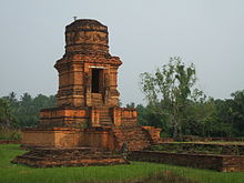
The Padang Lawas archaeological site is partly located in the regency. The site covers approximately 1,500 km², encompassing the kecamatan (districts) of Portibi and Padang Bolak in this regency, and Barumun and Barumun Tengah in the Padang Lawas Regency. Hindu-Buddhist remains are found on the site, including structures called biaro (from Sanskrit vihara, meaning "temple" or "monastery").
The village of Batu Gana in Padang Bolak Julu district is the location of a burial site consisting of a megalithic structure.[citation needed]
In the village of Padang Bujur in the same district, one can also find megalithic remains and what seems to be the base for a padmasana.[citation needed]
Other megalithic remains are found at Aek Korsik and Aek Tolong Huta, also in the Padang Bolak district.[citation needed]
| Wikimedia Commons has media related to North Padang Lawas Regency. |
References[]
- ^ Badan Pusat Statistik, Jakarta, 2021.
- ^ Biro Pusat Statistik, Jakarta, 2011
- ^ Badan Pusat Statistik, Jakarta, 2021.
- ^ "BPS Padang Lawas Utara". palutakab.bps.go.id (in Indonesian).
- ^ Jump up to: a b Biro Pusat Statistik, Jakarta, 2011.
- ^ Badan Pusat Statistik, Jakarta, 2021.
- ^ Badan Pusat Statistik, Jakarta, 2021.
- Simanjuntak, Truman, M. Hisyam, Bagyo Prasetyo, Titi Surti Nastiti (éds.), Archaeology: Indonesian perspective : R.P. Soejono's festschrift, LIPI, Jakarta, 2006, ISBN 979-26-2499-6

Coordinates: 1°27′36″N 99°40′25″E / 1.4601°N 99.6735°E

This North Sumatra location article is a stub. You can help Wikipedia by . |
- Regencies of North Sumatra
- North Sumatra geography stubs