Outline of Transnistria

The following outline is provided as an overview of and topical guide to Transnistria:
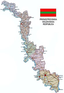
Transnistria is a breakaway state located mostly on a strip of land between the River Dniester and the eastern Moldovan border with Ukraine. Since its declaration of independence in 1990, and especially after the War of Transnistria in 1992, it has been governed as the Pridnestrovian Moldavian Republic (PMR, also known as Pridnestrovie), a state with limited recognition that claims territory to the east of the River Dniester, and also to the city of Bender (Tighina) and its surrounding localities on the west bank in the historical region of Bessarabia. The names "Transnistria" and "Pridnestrovie" both refer to the Dniester River. Unrecognised by any United Nations member state, Transnistria is designated by the Republic of Moldova as the Transnistria autonomous territorial unit with special legal status (Unitatea teritorială autonomă cu statut juridic special Transnistria), or Stînga Nistrului ("Left Bank of the Dniester").
General reference[]
- Pronunciation:
- Common English country name: Transnistria
- Official English country name: The Pridnestrovian Moldavian Republic
- Common endonym(s): Transnistrian, Pridnestrovian
- Official endonym(s):
- Adjectival(s):
- Demonym(s):
- Etymology: Name of Transnistria
- ISO country codes: See the Outline of Moldova
- ISO region codes: See the Outline of Moldova
- Internet country code top-level domain: See the Outline of Moldova
Geography of Transnistria[]
Geography of Transnistria
- Transnistria is: a de facto independent[1][2][3][4] though partially recognised sovereign state
- Location:
- Northern Hemisphere and Eastern Hemisphere
- Eurasia
- Time zone: Eastern European Time (UTC+02), Eastern European Summer Time (UTC+03)
- Extreme points of Transnistria
- :
- : 4163 km2
- Atlas of Transnistria
Environment of Transnistria[]
- Climate of Transnistria
- World Heritage Sites in Transnistria: None
Regions of Transnistria[]
Ecoregions of Transnistria[]
Administrative divisions of Transnistria[]
Administrative divisions of Transnistria
- Raions of Transnistria
Raions of Transnistria[]
Raions of Transnistria
- Camenca (Romanian: Camenca, Moldovan Cyrillic: Кáменка)
- Dubăsari (Romanian: Dubăsari, Moldovan Cyrillic: Дубосса́ры)
- Grigoriopol (Romanian: Grigoriopol, Moldovan Cyrillic: Григорио́поль)
- Rîbniţa (Romanian: Rîbnița, Moldovan Cyrillic: Рыбница)
- Slobozia (Romanian: Slobozia, Moldovan Cyrillic: Слободзе́я)
Municipalities of Transnistria[]
- Capital of Transnistria: Tiraspol
- Cities of Transnistria
- Bendery (Бендéры), officially a separate municipality from Transnistria
- Tiraspol (Тира́споль)
Demography of Transnistria[]
Demographics of Transnistria
Government and politics of Transnistria[]
- Form of government: Presidential republic
- Capital of Transnistria: Tiraspol
- Elections in Transnistria
- Political parties in Transnistria
Branches of the government of Transnistria[]
Executive branch of the government of Transnistria[]
- Head of state: President of Transnistria, Vadim Krasnoselsky
- Cabinet of Transnistria
Legislative branch of the government of Transnistria[]
- Parliament of Transnistria (unicameral)
Judicial branch of the government of Transnistria[]
Foreign relations of Transnistria[]
Foreign relations of Transnistria
International organization membership[]
- none [5]
Law and order in Transnistria[]
- Constitution of Transnistria
- Crime in Transnistria
- Human rights in Transnistria
- Law enforcement in Transnistria
Military of Transnistria[]
Military of Transnistria
- Command
- Forces
Local government in Transnistria[]
History of Transnistria[]
Culture of Transnistria[]
| Part of a series on the |
| Culture of Transnistria |
|---|
 |
| History |
| People |
| Languages |
| Festivals |
| Religion |
- Media in Transnistria
- National symbols of Transnistria
- Coat of arms of Transnistria
- Flag of Transnistria
- National anthem of Transnistria
- Public holidays in Transnistria
- Religion in Transnistria
- World Heritage Sites in Transnistria: None
Art in Transnistria[]
- Television in Transnistria
Economy and infrastructure of Transnistria[]
Economy of Transnistria
- Economic rank, by nominal GDP (2007):
-
- Internet in Transnistria
- Currency of Transnistria: Ruble
- ISO 4217: N/A (informally PRB)
- Transnistrian companies
Education in Transnistria[]
See also[]
| Romanian language edition of Wikipedia, the free encyclopedia |
| Ukrainian language edition of Wikipedia, the free encyclopedia |
| Russian language edition of Wikipedia, the free encyclopedia |
- Women in Transnistria
- List of international rankings
- List of Transnistria-related topics
- Outline of Europe
- Outline of geography
- Outline of Moldova
References[]
- ^ Jos Boonstra, Senior Researcher, Democratisation Programme, FRIDE. Moldova, Transnistria and European Democracy Policies Archived 2018-08-08 at the Wayback Machine, 2007
- ^ Gerald Hinteregger, Hans-Georg Heinrich (editors), Russia — Continuity and Change, Hinteregger, Gerald; Heinrich Hans-Georg (2004). Russia — Continuity and Change. (editors). Springer. pp. 174. ISBN 3-211-22391-6.
- ^ Rosenstiel, Francis; Edith Lejard; Jean Boutsavath; Jacques Martz (2002). Annuaire Europeen 2000/European Yearbook 2000. Martinus Nijhoff Publishers. ISBN 90-411-1844-6.
- ^ Barry Bartmann, Tozun. Bahcheli (2004). De Facto States: The Quest for Sovereignty. Routledge. ISBN 0-7146-5476-0.
- ^ "Moldova". The World Factbook. United States Central Intelligence Agency. July 2, 2009. Retrieved July 23, 2009.
External links[]
 Definitions from Wiktionary
 Media from Wikimedia Commons
 News from Wikinews
 Quotations from Wikiquote
 Texts from Wikisource
 Textbooks from Wikibooks
 Resources from Wikiversity
![]() Wikimedia Atlas of Transnistria
Wikimedia Atlas of Transnistria
- BBC: Profile of Trans-Dniester
- Economist: The black hole that ate Moldova
- Organization for Security and Co-operation in Europe Mission to Moldova
- Radio Free Europe: Transdniester Conflict Was Long In The Making
- Jos Boonstra, "Moldova, Transnistria, and European Democracy Polices", FRIDE, February 2007
- Stuart Hensel, Moldova Strategic Conflict Assessment (SCA), Economist Intelligence Unit.
- Local links
- (in Russian) "Chelovek i ego Prava" ("Man and his Rights"), local newspaper
- (in English, Romanian, and Russian) Conflict.md, site about the conflict
- (in English, Romanian, and Russian) Moldova Azi: News from Moldova, news portal
- (in English, Romanian, and Russian) Moldova.org, non-governmental country portal
- (in English and Russian) PMR News, English-language news and commentaries
- (in English and Russian) Pridnestrovie.net, official English site of the PMR authorities
- (in English, Romanian, and Russian) Transnistria.md, English-language news and interviews
- (in English and Russian) VisitPMR.com, official tourist information
- (in English and Russian) Website of the Supreme Council (Parliament) of PMR, official site
- Outlines of countries
- Transnistria
- Transnistria-related lists