Pantabangan
Pantabangan | |
|---|---|
| Municipality of Pantabangan | |
 | |
 Seal | |
 Map of Nueva Ecija with Pantabangan highlighted | |
show OpenStreetMap | |
 Pantabangan Location within the Philippines | |
| Coordinates: 15°49′N 121°09′E / 15.82°N 121.15°ECoordinates: 15°49′N 121°09′E / 15.82°N 121.15°E | |
| Country | Philippines |
| Region | Central Luzon |
| Province | Nueva Ecija |
| District | 2nd district |
| Founded | 1701 |
| Barangays | 14 (see Barangays) |
| Government | |
| • Type | Sangguniang Bayan |
| • Mayor | Roberto T. Agdipa |
| • Vice Mayor | Monaliza H. Agdipa |
| • Representative | Micaela S. Violago |
| • Electorate | 24,202 voters (2019) |
| Area | |
| • Total | 392.56 km2 (151.57 sq mi) |
| Elevation | 260 m (850 ft) |
| Highest elevation | 547 m (1,795 ft) |
| Lowest elevation | 107 m (351 ft) |
| Population (2020 census) [3] | |
| • Total | 31,763 |
| • Density | 81/km2 (210/sq mi) |
| • Households | 6,107 |
| Economy | |
| • Income class | 1st municipal income class |
| • Poverty incidence | 24.92% (2015)[4] |
| • Revenue | ₱160,347,590.07 (2016) |
| Service provider | |
| • Electricity | Pantabangan Municipal Electric System (PAMES) |
| Time zone | UTC+8 (PST) |
| ZIP code | 3124 |
| PSGC | |
| IDD : area code | +63 (0)44 |
| Climate type | tropical monsoon climate |
| Native languages | Ilocano Tagalog |


Pantabangan, officially the Municipality of Pantabangan, is a 1st class municipality in the province of Nueva Ecija, Philippines. According to the 2020 census, it has a population of 31,763 people. [3]
This is the site of the Pantabangan Dam and Lake.
Located in the northern part of Nueva Ecija, Pantabangan is located at the foot of Mt. Mabilog below Mt. Dalimanok which are found between Sierra Madre and Caraballo Mountain ranges. It is home to the Pantabangan–Carranglan Watershed Forest Reserve.
History[]
The place was discovered on November 30, 1645, by Fr. Juan Alonzo de Abarca, an Augustinian priest who with the 29th Spanish mission in the Philippines.
The village grew into a settlement and was officially included in the map of the Philippines in 1747. In 1900, Pantabangan formally became a town.
In early 16th to 17th centuries, the “Id-dules” (Aetas or ) and (Ilongots) tribe inhabited the southern Sierra Madre and Caraballo Mountains. Based on Mr. Elito V. Circa, a folk visual artist and a writer who wrote most of the Pantabangan-Egongot arts and culture and interviewed some of the Egongot chieftains from Aurora province. He discovered that Pantabangan (Pantabanganan in early 18th century) came from the root Ilongot word "Sabangan or Sabanganan" that means "junction of water streams". It was learned that most of the places in Central Luzon were derived from Ilongot word like , , Cadanglaan (now Carranglan), Kabaritan (Now San Jose City) and others. Bungamong (Bongabon) and Cadanglaan was formerly sitio of Pantabangan and Kabaritan also part of Pantabangan.
When the Second World War broke out, Japanese Imperial forces occupied the town municipality of Pantabangan in 1942 under the Japanese Occupation. During the Liberation, combined military forces of the Filipino troops under the Philippine Commonwealth Army and Philippine Constabulary units and the American troops of the United States Army and the U.S. Army Air Forces came, invaded and recaptured the town of Pantabangan and defeated Japanese soldiers in the Battle of Pantabangan and ended World War II.
In May 1966, the Old Philippine Congress passed the Upper Pampanga River Project Act (Republic Act 5499) authorizing the construction of the Pantabangan Dam and its appurtenant structures. The groundbreaking ceremony led by then President Ferdinand E. Marcos took place on June 11, 1971. The project was finally completed in August 1974.
The construction of the Dam had great economic and social impact on the lives of Pantabangeños. About 8,100 hectares (20,000 acres) of productive farmland and the town center (East and West Poblacion) along with seven outlying barangays (Villarica, Liberty, Cadaclan, San Juan, Napon-Napon, Marikit and Conversion) were submerged under the new lake. Residents were relocated to higher ground overlooking the vast reservoir, which became the new Pantabangan town center. Before the expansion of the dam through the Casecnan Project in the 1990s, the belfry of the 18th century church resurfaced from the dam's summer low water level. During drought in 1983, some areas of the old town emerged.
The Pantabangan Dam is claimed[by whom?] to be the second largest dam in Asia, and supplies the irrigation requirements for about 77,000 hectares (190,000 acres) of agricultural lands in Central Luzon. Its power station generates 112 megawatts of hydroelectric power.
In February 1996, then President Fidel V. Ramos led the ground-breaking ceremony of the Casecnan Transbasin Project, a 27 kilometres (17 mi) tunnel from the Casecnan River in Nueva Viscaya to a terminal point at the Pantabangan reservoir and was commissioned on December 11, 2001. The project aims to augment the capacity of the dam to irrigate an additional 50,000 hectares (120,000 acres) of agricultural land and generate an additional 140 megawatts of hydroelectric power for the Luzon grid.
The present Pantabangan town has 14 barangays and a total land area of about 41,735 hectares. The succeeding years since its relocation saw its progress from a fifth-class municipality in 1975, then to a fourth-class, then to a second class Municipality in 2006 and finally, in July 2008, pursuant to Section 2 of the Department of Finance Order No. 23-08, Pantabangan was reclassified as First-Class Municipality. It is the only town in the Philippines which boasts of three hydroelectric plants within its territorial jurisdiction.
Barangays[]
Pantabangan is politically subdivided into 14 barangays.
- Cadaclan
- Cambitala
- Conversion
- Ganduz
- Liberty
- Malbang
- Marikit
- Napon-Napon
- Poblacion East
- Poblacion West
- Sampaloc
- San Juan
- Villarica
- Fatima
Climate[]
| hideClimate data for Pantabangan, Nueva Ecija | |||||||||||||
|---|---|---|---|---|---|---|---|---|---|---|---|---|---|
| Month | Jan | Feb | Mar | Apr | May | Jun | Jul | Aug | Sep | Oct | Nov | Dec | Year |
| Average high °C (°F) | 28 (82) |
29 (84) |
30 (86) |
32 (90) |
31 (88) |
30 (86) |
29 (84) |
28 (82) |
28 (82) |
28 (82) |
29 (84) |
28 (82) |
29 (84) |
| Average low °C (°F) | 18 (64) |
18 (64) |
19 (66) |
20 (68) |
22 (72) |
22 (72) |
22 (72) |
22 (72) |
22 (72) |
22 (72) |
20 (68) |
18 (64) |
20 (69) |
| Average precipitation mm (inches) | 4 (0.2) |
6 (0.2) |
7 (0.3) |
12 (0.5) |
61 (2.4) |
89 (3.5) |
96 (3.8) |
99 (3.9) |
81 (3.2) |
88 (3.5) |
37 (1.5) |
13 (0.5) |
593 (23.5) |
| Average rainy days | 2.5 | 3.0 | 4.1 | 6.3 | 15.8 | 19.4 | 22.5 | 21.6 | 20.1 | 17.5 | 9.6 | 4.0 | 146.4 |
| Source: Meteoblue [5] | |||||||||||||
Demographics[]
|
| |||||||||||||||||||||||||||||||||||||||||||||||||||
| Source: Philippine Statistics Authority [6] [7] [8][9] | ||||||||||||||||||||||||||||||||||||||||||||||||||||

Economy[]
| Poverty Incidence of Pantabangan | |
| Source: Philippine Statistics Authority[10][11][12][13][14][15] | |
Arts and Culture[]

The Pandawan Festival made its debut in April 2008, showcasing many local talents as well as other entertainments including Indigenouism art activities like art workshop and rural development thru art awareness programs. Tourists like to visit especially the water sport enthusiasts for jetskiing, boat riding and even bass fishing.
The memories and legends of the old town are depicted by Pantabangan's child folk painter, Elito V. Circa on his Alamat ni Minggan (Legend of Minggan), using his blood and hair on his painting. The painter always depicting the life of Pantabangan from the 70s (time where the town of Pantabangan was submerged by the water) to the present with the style of creating image of Minggan on every painting that he made. Pantabangan has sacrificed its land as it was drowned and made into a dam for the benefit of other towns by providing ample water supply for their crops.
Jason Abalos is also known showbiz artist, a member of ABS-CBN's circle of homegrown talents named Star Magic. He was discovered after joining Star Circle Quest, a reality show in search of new actors also hails from Pantabangan. Some part of history of the Pantabangan like significant birds, streets and prominent leaders and people was included in the lyrics/songs of Dr. Bernardo Dela Merced a singing doctor and Pantabangan folk singer.
Tagalog is predominantly spoken in Pantabangan followed by Ilocano dialect. People of Pantabangan "Pantabangenian" are also known for their very distinct strong Pantabangan accent, called "Adyu-ari".
Gallery[]
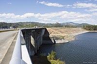
Pantabangan Dam

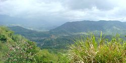
Forests and mountains (Cadaclan)

Pantabangan N.E. Transport and Public Market (East Poblacion)

Hills and forests (Marikit)


References[]
- ^ Municipality of Pantabangan | (DILG)
- ^ "2015 Census of Population, Report No. 3 – Population, Land Area, and Population Density" (PDF). Philippine Statistics Authority. Quezon City, Philippines. August 2016. ISSN 0117-1453. Archived (PDF) from the original on May 25, 2021. Retrieved July 16, 2021.
- ^ Jump up to: a b Census of Population (2020). "Region III (Central Luzon)". Total Population by Province, City, Municipality and Barangay. PSA. Retrieved 8 July 2021.
- ^ https://psa.gov.ph/sites/default/files/City%20and%20Municipal-level%20Small%20Area%20Poverty%20Estimates_%202009%2C%202012%20and%202015_0.xlsx; publication date: 10 July 2019; publisher: Philippine Statistics Authority.
- ^ "Pantabangan: Average Temperatures and Rainfall". Meteoblue. Retrieved 4 May 2020.
- ^ Census of Population (2015). "Region III (Central Luzon)". Total Population by Province, City, Municipality and Barangay. PSA. Retrieved 20 June 2016.
- ^ Census of Population and Housing (2010). "Region III (Central Luzon)". Total Population by Province, City, Municipality and Barangay. NSO. Retrieved 29 June 2016.
- ^ Censuses of Population (1903–2007). "Region III (Central Luzon)". Table 1. Population Enumerated in Various Censuses by Province/Highly Urbanized City: 1903 to 2007. NSO.
- ^ "Province of Nueva Ecija". Municipality Population Data. Local Water Utilities Administration Research Division. Retrieved 17 December 2016.
- ^ "Poverty incidence (PI):". Philippine Statistics Authority. Retrieved 28 December 2020.
- ^ https://psa.gov.ph/sites/default/files/NSCB_LocalPovertyPhilippines_0.pdf; publication date: 29 November 2005; publisher: Philippine Statistics Authority.
- ^ https://psa.gov.ph/sites/default/files/2003%20SAE%20of%20poverty%20%28Full%20Report%29_1.pdf; publication date: 23 March 2009; publisher: Philippine Statistics Authority.
- ^ https://psa.gov.ph/sites/default/files/2006%20and%202009%20City%20and%20Municipal%20Level%20Poverty%20Estimates_0_1.pdf; publication date: 3 August 2012; publisher: Philippine Statistics Authority.
- ^ https://psa.gov.ph/sites/default/files/2012%20Municipal%20and%20City%20Level%20Poverty%20Estima7tes%20Publication%20%281%29.pdf; publication date: 31 May 2016; publisher: Philippine Statistics Authority.
- ^ https://psa.gov.ph/sites/default/files/City%20and%20Municipal-level%20Small%20Area%20Poverty%20Estimates_%202009%2C%202012%20and%202015_0.xlsx; publication date: 10 July 2019; publisher: Philippine Statistics Authority.
External links[]
| Wikimedia Commons has media related to Pantabangan. |
- Pantabangan Profile at PhilAtlas.com
- Official website
- Philippine Standard Geographic Code
- Philippine Census Information
- Local Governance Performance Management System
| show Places adjacent to Pantabangan |
|---|
| show |
|---|
| show Authority control |
|---|
- Municipalities of Nueva Ecija
- Populated places on the Pampanga River
- 1645 establishments in the Spanish Empire