Pioneer Square station
| Link light rail station | |||||||||||||||||||||
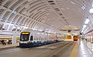 A light rail train and bus at Pioneer Square station, pictured in 2009 | |||||||||||||||||||||
| Location | 3rd Avenue and James Street Seattle, Washington, U.S. | ||||||||||||||||||||
| Coordinates | 47°36′10″N 122°19′53″W / 47.60278°N 122.33139°WCoordinates: 47°36′10″N 122°19′53″W / 47.60278°N 122.33139°W | ||||||||||||||||||||
| Owned by | King County Metro | ||||||||||||||||||||
| Line(s) | |||||||||||||||||||||
| Platforms | 2 side platforms | ||||||||||||||||||||
| Tracks | 2 | ||||||||||||||||||||
| Connections | |||||||||||||||||||||
| Construction | |||||||||||||||||||||
| Structure type | Tunnel | ||||||||||||||||||||
| Parking | Pay parking nearby | ||||||||||||||||||||
| Disabled access | Yes | ||||||||||||||||||||
| History | |||||||||||||||||||||
| Opened | September 15, 1990 | ||||||||||||||||||||
| Rebuilt | 2005–2007 | ||||||||||||||||||||
| Passengers | |||||||||||||||||||||
| 4,677 daily boardings (2019)[1] | |||||||||||||||||||||
| Services | |||||||||||||||||||||
| |||||||||||||||||||||
| |||||||||||||||||||||

Pioneer Square station is a light rail station that is part of the Downtown Seattle Transit Tunnel in Seattle, Washington, United States. The station is located under 3rd Avenue at James Street, between University Street and International District/Chinatown stations. It is served by Line 1, part of Sound Transit's Link light rail system, and provides connections to local buses and Colman Dock, a major ferry terminal serving areas west of Seattle.
The station consists of two side platforms situated under street level, with two mezzanines connecting to the surface at James Street and Yesler Way in Seattle's Pioneer Square neighborhood. It opened on September 15, 1990, and was used exclusively by buses until 2009. The tunnel and stations closed for almost two years, from 2005 to 2007, for renovation and modifications to accommodate light rail trains. Link light rail service to Pioneer Square station began on July 18, 2009, and bus service ended on March 23, 2019. Trains serve the station twenty hours a day on most days at a frequency of six minutes during peak periods and 12–20 minutes at other times. In early 2020, Pioneer Square station served as a transfer point between trains with a temporary center platform as part of construction for the East Link Extension.
Location[]
Pioneer Square station is located under 3rd Avenue between Cherry Street and Yesler Way in the Pioneer Square neighborhood of Downtown Seattle. The station is at the northern end of the Pioneer Square National Historic District, where the city's oldest buildings are located, and is near the Seattle Underground Tour and the Klondike Gold Rush National Historical Park.[2][3] To the north and east is the Seattle Civic Center, a complex of city and King County government office buildings, including Seattle City Hall and the King County Courthouse.[4][5] Pioneer Square station is six blocks east of Colman Dock, the city's primary ferry terminal for Washington State Ferries and King County Water Taxi service.[6]
Much of the non-government and non-historic land use around Pioneer Square station is for high-rise offices and multi-family housing. Within a 1⁄2-mile (0.8 km) radius of the station is an estimated population of 12,866 people, and approximately 69,795 jobs.[7] Nearby office towers include Smith Tower,[4] the Columbia Center, and Wells Fargo Center.[8] The corporate headquarters of logging company Weyerhaeuser was moved from Federal Way to Occidental Park near Pioneer Square station in 2016; the company cited transit access as one of its main reasons to choose the neighborhood.[9][10]
History[]
Earlier proposals[]
Pioneer Square was developed as Seattle's initial settlement in the 1850s and continued to serve as the city's downtown into the early 20th century.[11] In 1911, civil engineer Virgil Bogue presented a comprehensive plan for the city of Seattle, including a rapid transit system centered around a "trunk" subway under 3rd Avenue, passing through Pioneer Square and the growing commercial and retail district to the north.[12][13] The plan was rejected by voters on March 5, 1912,[14] and the 3rd Avenue subway was unsuccessfully proposed twice in the 1920s.[15][16]
In the late 1960s, the Forward Thrust Committee put forward a ballot measure to fund a rapid transit system in the Seattle metropolitan area, including a downtown subway under 3rd Avenue with a station between Cherry and James streets.[17][18] The ballot measure, requiring a supermajority to support bonding to augment $385 million in local funding with $765 million from the Urban Mass Transportation Administration, failed to reach the 60 percent threshold in 1968 and again during a second vote in 1970.[19][20] The failure of the Forward Thrust ballot measures led to the creation of Metro Transit in 1972, operating bus service across King County.[21]
Bus tunnel[]
Metro Transit began planning a bus tunnel through downtown Seattle in the 1970s, to be eventually converted to use by light rail trains. Metro approved the construction of a bus tunnel under 3rd Avenue in 1983,[22] and chose to site one of the tunnel's five stations near the King County Courthouse at 3rd Avenue and James Street.[23][24] The station was to be completed by late 1989 and use brick, stone, and tile to complement the design of nearby Pioneer Square.[25][26]
Metro awarded a $44.1 million contract to a joint venture of Atkinson and Dillingham companies to build the tunnel's 3rd Avenue segment as well as Pioneer Square station. Excavation of the station from street level began in March 1987,[27] and the project's twin tunnel boring machines reached James Street from Union Station in September.[28] In June 1987, Atkinson-Dillingham and Metro were fined $80,000 after drilling at the station severed three electric power transmission lines, causing a day-long power outage in downtown Seattle, affecting the and .[29] Work in the tunnel station was also blamed for shaking in the City Hall and Public Safety Building, requiring monitoring equipment to be set up by Metro.[30]
By late 1988, the Pioneer Square station structure was 70 percent complete, and work had begun on the station's entrances and the vaulted ceiling.[31] The station was the subject of two controversies during its construction over the use of South African materials in its construction, as the country was then under a Metro boycott for its Apartheid policies. In late 1987, Atkinson-Dillingham was forced to remove steel beams used for temporary shoring at the station box after unknowingly sourcing it from South Africa.[32] Metro later acquired South African black granite to be used in the station's platform and mezzanine, which was discovered and returned; the incident resulted in the resignation of Metro's executive director, amid outcry from African American leaders.[33][34]
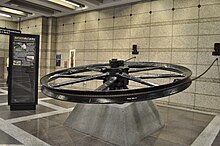
Tunnel construction was completed in June 1990, and was celebrated with a soft opening of Pioneer Square station and the re-opening of Prefontaine Park.[35] During preparation for the resurfacing of 3rd Avenue above the new tunnel station, workers discovered an 11-foot (3.4 m) cable car flywheel that had been buried after service on the Yesler Way line ceased in 1940.[36] The flywheel was later restored and placed in the south mezzanine of Pioneer Square station.[4] Bus service in the Downtown Seattle Transit Tunnel began on September 15, 1990, with several Metro bus routes moved into the tunnel from surface streets.[37] At the time of its opening, Pioneer Square station had the longest and steepest escalator west of the Mississippi River.[38] All service on routes using the tunnel was operated by dual-mode buses, which operated as diesel buses outside the tunnel and electrically, as trolleybuses, when inside the tunnel. During its early months, Pioneer Square and other stations were affected by serious water leaks, which splashed water onto walkways during the tunnel's first winter in operation.[39] The leaks were later fixed by Metro contractors, but remained visible in the form of rust stains on the station ceiling.[40][41]
Light rail[]
In the early 1990s, a regional transit authority (RTA) was formed to plan and construct a light rail system for the Seattle area. After an unsuccessful attempt in 1995, regional voters passed a $3.9 billion plan to build light rail under the RTA in 1996.[42] The downtown transit tunnel had already been planned for eventual light rail use and was built with tracks that would be incorporated into the initial system.[43][44] The RTA, later renamed Sound Transit, approved the tunnel as part of the route of its initial light rail line in 1999.[45] Ownership of the tunnel, including its stations, was transferred to Sound Transit in 2000 but returned two years later to King County Metro under a joint-operations agreement.[46][47]
The Public Safety Building, located at the station's northeast entrance, was demolished in 2005. In its place, the city planned to build Seattle Civic Square, a mixed-use skyscraper, with a new entrance to the station.[48] As of 2016, the project is on hold and a temporary entrance has been erected at street level.[49]
The downtown transit tunnel closed on September 23, 2005, for a two-year, $82.7 million renovation to accommodate light rail vehicles. The renovation included the installation of new rails, a lowered roadbed at stations for level boarding, new signalling systems and emergency ventilation.[50][51] The tunnel reopened on September 24, 2007,[52] and Link light rail service began on July 18, 2009, from Westlake station to Tukwila International Boulevard station.[53][54]
Bus service within the downtown transit tunnel ended on March 23, 2019, due to the expansion of the Washington State Convention Center at the site of Convention Place station, which includes demolition of the north portal. The tunnel became exclusively served by light rail trains, while the remaining seven bus routes were relocated to surface streets and nearby bus stops on 2nd, 3rd, 4th, and 5th avenues.[55][56]
As part of East Link Extension construction in early 2020, Pioneer Square station was outfitted with a temporary third platform in the center to allow passengers on terminating single-tracked trains to transfer.[57] The temporary platform was installed during two weekend closures in October 2019 and was used from January to March 2020.[58][59]
Station layout[]
| Street level | Entrances/Exits | |
| Mezzanine level | Ticket vending machines, to Entrances/Exits | |
| Platform level | Side platform, doors will open on the right | |
| Northbound | ← | |
| Southbound | | |
| Side platform, doors will open on the right | ||

Pioneer Square station consists of two underground side platforms used to load passengers onto trains and buses, a mezzanine level, and several surface entrances.[60] A temporary center platform is used to transfer riders between trains during single-tracking and has no means of egress except for through the train.[59] The station has two mezzanines on its north and south ends, with the center portion opened to the platform below. The north mezzanine under James Street has two entrances: a pair of escalators and a stairway to 3rd Avenue at the future site of Seattle Civic Square;[61] and a single escalator and stairway to 2nd Avenue in the Lyon Building. The south mezzanine has a single entrance to Prefontaine Park at Yesler Way between 2nd and 3rd avenues, under a large pergola similar to an older streetcar shelter in Pioneer Square. The Prefontaine Park entrance houses an 8-by-50-foot (2.4 by 15.2 m) ceramic mural created by artist Laura Sindell, depicting people-like figures, a 19th-century quilt pattern, a Coast Salish basket design, and a dugout canoe.[62][63] Several of the station's entrances feature inscribed quotes from historic Seattle figures, including Chief Seattle, "Doc" Maynard, and Arthur A. Denny. The south mezzanine also has a large flywheel once used by the Yesler Way cable car and later buried in a vault until its discovery during tunnel construction.[4][36] Pioneer Square station is approximately 570 feet (170 m) long, 70 feet (21 m) wide, and 60 to 70 feet (18 to 21 m) deep.[64]
Designed by architect Jerry McDevitt, the station has an arched vault ceiling that is meant to reflect the area's historic buildings.[60][65] The platform level also makes extensive use of red and gray granite, matching the King County Courthouse and former ,[62] and railings that resemble hitching posts and hanging lamps.[4][66] Artists Kate Ericson and Mel Ziegler created the station's two "artifact clocks", which hang from the mezzanine at each end of the platform. The north mezzanine clock uses materials from modern construction, including granite, steel beams, and electrical wires; the south mezzanine clock incorporates artifacts found during construction dating back to the city's early history, including cobblestones, brick, and cast-iron pipes.[60][67] Both clocks use various tools used during construction, including a handsaw and industrial-size tape measure, for the clock face's numerals.[62]
The station's pictogram, a frigate sailing ship, pays homage to Seattle's roots as a timber supplier for shipbuilders. It was created in 2009 by Christian French as part of the Stellar Connections series and its points represent nearby destinations, including Seattle City Hall, Colman Dock, the Klondike Gold Rush National Historical Park, and King Street Station.[68]
Services[]
Pioneer Square station is part of the Downtown Seattle Transit Tunnel, which is served by Line 1 of Sound Transit's Link light rail network. Light rail trains run from Northgate to the University of Washington campus, Downtown Seattle, the Rainier Valley, and Seattle–Tacoma International Airport. Pioneer Square is the eleventh northbound station from Angle Lake and seventh southbound station from Northgate, situated between International District/Chinatown and University Street stations. Light rail trains serve Pioneer Square twenty hours a day on weekdays and Saturdays, from 5:00 am to 1:00 am, and eighteen hours on Sundays, from 6:00 am to 12:00 am; during regular weekday service, trains operate roughly every eight to ten minutes during rush hour and midday operation, respectively, with longer headways of fifteen minutes in the early morning and twenty minutes at night. During weekends, trains arrive at Pioneer Square station every ten minutes during midday hours and every fifteen minutes during mornings and evenings. The station is approximately 33 minutes from SeaTac/Airport station and five minutes from Westlake station.[69] In 2019, an average of 4,677 passengers boarded Link trains at Pioneer Square station on weekdays.[1]
In addition to light rail service, Pioneer Square station is adjacent to several surface bus stops near its entrances, served by King County Metro, Community Transit, and Sound Transit Express routes.[70] Two of Metro's RapidRide lines, the D Line to Ballard and the E Line on Aurora Avenue North to Shoreline, terminate in Pioneer Square.[71] The area is also served by several east–west bus routes that travel towards First Hill, the Central District, and Leschi.[72] During disruptions to light rail service, King County Metro also runs a special route between all light rail stations that stops on 3rd Avenue between Jefferson and James streets to serve Pioneer Square station.[73]
Pioneer Square station is also the main entry to Colman Dock and Pier 50,[6] connecting to Washington State Ferries service to Bainbridge Island and Bremerton; Kitsap Fast Ferries service to Bremerton; and King County Water Taxi service to West Seattle and Vashon Island.[72] A future streetcar line is planned to serve a stop at 1st Avenue and Yesler Way, one block from the station's Prefontaine Park entrance.[74][75]
From 2009 to 2019, several bus routes also ran in the tunnel alongside Link light rail. The final set of bus routes in the tunnel were divided into three bays by their outbound direction: Bay A was served by three routes heading north toward Northgate and the University District and east towards Kirkland (routes 41, 74, and 255); Bay C was served by three routes heading south through the SODO Busway toward Kent and Renton (routes 101, 102, and 150); and Bay D was served by one route heading east via Interstate 90 to Bellevue (Sound Transit Express route 550).[72] The bus routes were relocated in March 2019 to new stops on 2nd, 3rd, and 5th avenues to serve Pioneer Square and the surrounding area.[76][77]
References[]
- ^ a b "Q4 2019 Service Delivery Quarterly Performance Report" (PDF). Sound Transit. February 27, 2020. Retrieved July 30, 2020.
- ^ "Pioneer Square". Seattle Department of Neighborhoods. Archived from the original on June 20, 2017. Retrieved May 27, 2017.
- ^ Seattle's Original Neighborhood: Pioneer Square (PDF) (Map). Alliance for Pioneer Square. Archived (PDF) from the original on December 17, 2016. Retrieved May 27, 2017.
- ^ a b c d e Transit Tunnel: Pioneer Square Station (PDF) (Map). King County Metro Transit. September 2007. Archived (PDF) from the original on December 22, 2014. Retrieved May 27, 2017.
- ^ "Seattle Municipal Civic Center Master Plan" (PDF). City of Seattle. June 1999. Archived from the original (PDF) on February 28, 2017. Retrieved May 27, 2017.
- ^ a b Central Link Light Rail Transit Project Draft Environmental Impact Statement, Volume 2. Sound Transit. November 30, 1998. p. 1-4. OCLC 40478464. Archived from the original on February 26, 2018. Retrieved May 27, 2017 – via Google Books.
- ^ Growing Transit Communities Oversight Committee (October 2013). "Pioneer Square: Light Rail/Bus" (PDF). The Growing Transit Communities Strategy. Puget Sound Regional Council. Retrieved May 27, 2017.
- ^ "Chapter 10: Station Area Profiles" (PDF). Background Report for Light Rail Station Area Planning in Seattle (Report). Seattle Department of Transportation. January 1999. p. 263. Archived from the original (PDF) on February 17, 2017. Retrieved May 27, 2017.
- ^ Miller, Brian (September 8, 2016). "On the Block: Weyerhaeuser may be downsizing but it'll soon have a big impact on Pioneer Square". Seattle Daily Journal of Commerce. Archived from the original on September 9, 2016. Retrieved May 27, 2017.
- ^ Newman, Morris (November 30, 2016). "Weyerhaeuser Moves Out of the Woods and Into Urban Seattle". The New York Times. p. B7. Archived from the original on May 30, 2017. Retrieved May 27, 2017.
- ^ Crowley, Walt (June 20, 2001). "Seattle Neighborhoods: Pioneer Square — Thumbnail History". HistoryLink. Archived from the original on May 14, 2017. Retrieved May 27, 2017.
- ^ Bogue, Virgil (1911). "Appendix No. III—Proposed Rapid Transit System". Plan of Seattle: Report of the Municipal Plans Commission. Seattle, Washington: Lowman & Hanford. p. 180. OCLC 1440455. Archived from the original on August 19, 2014. Retrieved May 27, 2017 – via Google Books.
- ^ "Municipal Plans Embrace Great Third Avenue Improvements". The Seattle Times. November 12, 1911. p. 25.
- ^ Crowley, Walt (September 17, 1972). "Virgil Bogue's plan: Seattle that might have been". The Seattle Times. pp. 8–9.
- ^ "2008 Find of the Month Archive: 1920 rapid transit plan". Seattle Municipal Archives. June 2008. Archived from the original on September 24, 2015. Retrieved May 27, 2017.
- ^ Trimble, William Pitt (1926). Seattle Rapid Transit Report to the City Planning Commission. Seattle Planning Commission. OCLC 14264109.
- ^ De Leuw, Cather & Company (October 30, 1967). "Chapter 8: Engineering Studies and Analyses". Report on a Comprehensive Public Transportation Plan for the Seattle Metropolitan Area. Municipality of Metropolitan Seattle. p. 93. OCLC 74314.
- ^ De Leuw, Cather & Company (February 19, 1970). "Chapter 1: Recommended Public Transportation Plan". The Rapid Transit Plan for the Metropolitan Seattle Area. Municipality of Metropolitan Seattle. p. 15. OCLC 120953.
- ^ McRoberts, Patrick (January 1, 1999). "King County voters on Forward Thrust bonds approve stadium and aquarium and nix transit on February 13, 1968". HistoryLink. Archived from the original on October 2, 2016. Retrieved May 27, 2017.
- ^ "Voters reject rail transit plan and three other Forward Thrust bond proposals on May 19, 1970". HistoryLink. September 19, 2002. Archived from the original on October 2, 2016. Retrieved May 27, 2017.
- ^ "Milestones—The 1970s". King County Metro. Archived from the original on May 7, 2017. Retrieved May 27, 2017.
- ^ Gough, William (November 4, 1983). "Metro Council OK's downtown transit tunnel". The Seattle Times. p. B1.
- ^ Nogaki, Sylvia (February 18, 1984). "Metro envisions city bus subway in 5 years". The Seattle Times. p. A6.
- ^ Nogaki, Sylvia (September 13, 1984). "Panel urges boring of Metro tunnel — and 5 stations". The Seattle Times. p. B2.
- ^ "Panel picks sites for tunnel stations". The Seattle Times. November 1, 1984. p. C6.
- ^ Lane, Bob (May 8, 1986). "Bus-tunnel stations will be designed to match buildings". The Seattle Times. p. B6.
- ^ Lane, Bob (March 2, 1987). "'Mighty mole' is a giant pest; Metro tunnel is a headache for merchants". The Seattle Times. p. B1.
- ^ Lane, Bob (September 14, 1987). "Mechanical moles". The Seattle Times. p. D1.
- ^ Brown, Charles E. (June 16, 1987). "City Light chiefs raps Metro on outage". The Seattle Times. p. B1.
- ^ Balter, Joni; Lane, Bob (February 6, 1988). "City hall gets shakes; tunnel gets blame". The Seattle Times. p. A1.
- ^ "Seattle Briefly". The Seattle Times. December 12, 1988. p. B3.
- ^ Lane, Bob (September 4, 1987). "Metro bans South African steel from bus-tunnel project". The Seattle Times. p. B2.
- ^ Lane, Bob (March 10, 1989). "Report to Metro finds no cover-up on granite". The Seattle Times. p. C1.
- ^ Pryne, Eric (January 27, 1989). "Firings sough over purchase from S. Africa". The Seattle Times. p. E1.
- ^ Lane, Bob (June 7, 1990). "Deafening silence: Bus tunnel's done". The Seattle Times. p. B1. Archived from the original on March 3, 2016. Retrieved May 27, 2017.
- ^ a b Lane, Bob (January 14, 1990). "Workers find relic from cable-car days". The Seattle Times. p. B11. Archived from the original on March 4, 2016. Retrieved May 27, 2017.
- ^ Rosenwald, Lonnie (September 15, 1990). "Seattle opens glitzy new bus tunnel today". The Spokesman-Review. Spokane, Washington: Cowles Publishing Company. p. A9. Retrieved May 27, 2017 – via Google News Archive.
- ^ Molnar, Jim (July 20, 1993). "Close to home: A rich crop of books on the Northwest". The Seattle Times. p. E4. Archived from the original on February 26, 2018. Retrieved May 27, 2017.
- ^ Anderson, Rick (November 14, 1990). "Bus tunnel users find no refuge from soggy Seattle". The Seattle Times. p. D1. Archived from the original on February 26, 2018. Retrieved May 27, 2017.
- ^ Lane, Bob (September 16, 1991). "Bus tunnel rolls into second year". The Seattle Times. p. B1. Archived from the original on February 2, 2017. Retrieved May 27, 2017.
- ^ Lange, Larry (March 6, 2005). "Getting There: Water leaks in bus tunnel may always be with us". Seattle Post-Intellignecer. Archived from the original on February 26, 2018. Retrieved May 27, 2017.
- ^ Schaefer, David (November 6, 1996). "Voters back transit plan on fourth try". The Seattle Times. p. A1. Archived from the original on March 3, 2016. Retrieved May 27, 2017.
- ^ Hamilton, Charles (November 6, 2006). "Sound Transit (King, Pierce, and Snohomish counties)". HistoryLink. Archived from the original on July 28, 2017. Retrieved May 27, 2017.
- ^ Pryne, Eric (October 13, 2005). "Bus-tunnel error years ago is costly in shutdown today". The Seattle Times. p. A1. Archived from the original on February 2, 2017. Retrieved May 27, 2017.
- ^ "Sound Transit Board achieves historic milestone by selecting route for central Link light rail" (Press release). Sound Transit. November 18, 1999. Archived from the original on July 28, 2017. Retrieved May 27, 2017.
- ^ Pryne, Eric (June 25, 2002). "Sound Transit, county agree to bus-tunnel plan". The Seattle Times. p. B1. Archived from the original on February 2, 2017. Retrieved May 27, 2017.
- ^ Pryne, Eric (May 12, 2002). "The bus tunnel tug-of-war". The Seattle Times. p. A1. Archived from the original on February 2, 2017. Retrieved May 27, 2017.
- ^ Pian Chan, Sharon (February 23, 2007). "From pit to landmark public plaza?". The Seattle Times. p. A1. Archived from the original on February 26, 2018. Retrieved May 27, 2017.
- ^ Beekman, Daniel (March 14, 2016). "Murray seeks deal with new company for stalled Civic Square project". The Seattle Times. p. B1. Archived from the original on July 23, 2017. Retrieved May 27, 2017.
- ^ Gilmore, Susan (September 23, 2005). "Bus tunnel shuts down tonight for 2 years". The Seattle Times. p. A1. Archived from the original on February 2, 2017. Retrieved May 27, 2017.
- ^ "Whats, whys of $82.7 million tunnel project". The Seattle Times. September 23, 2005. p. A15. Archived from the original on February 2, 2017. Retrieved May 27, 2017.
- ^ Gilmore, Susan (September 25, 2007). "Reopening of downtown Seattle bus tunnel goes smoothly". The Seattle Times. Archived from the original on February 2, 2017. Retrieved May 27, 2017.
- ^ "Link light rail launches new era of mobility for central Puget Sound" (Press release). Seattle, Washington: Sound Transit. July 18, 2009. Archived from the original on March 3, 2016. Retrieved May 27, 2017.
- ^ Lindblom, Mike (July 20, 2009). "Light-rail trains run smoothly, if not to capacity, on first day". The Seattle Times. p. B1. Archived from the original on November 28, 2016. Retrieved May 27, 2017.
- ^ Groover, Heidi (March 25, 2019). "Buses no longer using Seattle's transit tunnel; Monday commutes test new routes". The Seattle Times. Retrieved March 25, 2019.
- ^ Lindblom, Mike (June 25, 2017). "Reprieve for tunnel riders, but cascading projects to multiply Seattle's traffic woes". The Seattle Times. p. B1. Archived from the original on June 25, 2017. Retrieved June 26, 2017.
- ^ Lindblom, Mike (February 7, 2019). "Sound Transit prepares for its own construction squeeze in 2020". The Seattle Times. Retrieved February 7, 2019.
- ^ "Transit tunnel work to prepare for construction of Eastside light rail connection completed ahead of schedule" (Press release). Sound Transit. October 28, 2019. Retrieved October 31, 2019.
- ^ a b Lindblom, Mike (January 2, 2020). "Light-rail riders can expect more crowded, less frequent trains as downtown track construction begins". The Seattle Times. p. A1. Retrieved January 2, 2020.
- ^ a b c "Pioneer Square Station—the Pioneering Spirit". King County Metro. Archived from the original on September 9, 2015. Retrieved May 27, 2017.
- ^ Stiles, Marc (October 7, 2015). "After 8-year delay, Civic Square construction set to begin next year". Puget Sound Business Journal. Archived from the original on August 10, 2017. Retrieved May 27, 2017.
- ^ a b c Mathieson, Karen (September 12, 1990). "Tunnel Visions: Bus labyrinth beneath Seattle spawns gallery". The Seattle Times. p. C1. Archived from the original on October 6, 2014. Retrieved May 27, 2017.
- ^ "Untitled, (sculpture) by Sindell, Laura". Smithsonian Institution Research Information System. Smithsonian American Art Museum. Retrieved May 27, 2017.
- ^ Laprade, William T.; Thompson, Steven R. (1989). "Engineering Geology of the Downtown Seattle Transit Project" (PDF). Engineering Geology in Washington: Volume II. Washington State Department of Natural Resources: 667. OCLC 763131412. Archived (PDF) from the original on July 30, 2017. Retrieved May 27, 2017.
- ^ Brown, Patricia Leigh (October 4, 1990). "Currents; In Commuter Tunnel, Art at Every Stop". The New York Times. p. C3. Archived from the original on May 25, 2015. Retrieved May 27, 2017.
- ^ Demoro, Harre W. (February 19, 1990). "Seattle's Subway System of the Future: A Showcase For Art and Architecture". San Francisco Chronicle. p. A10.
- ^ Duncan, Don (August 10, 1990). "Metro shows off tunnel vision—High-tech artwork dazzles thousands at University Street bus station". The Seattle Times. p. B1. Archived from the original on October 3, 2016. Retrieved May 27, 2017.
- ^ "Stellar Connections". Sound Transit. Archived from the original on June 12, 2010. Retrieved July 27, 2017.
- ^ "Link 1 Line (Northgate — Angle Lake) schedule" (PDF). Sound Transit. October 2021. Archived (PDF) from the original on October 2, 2021. Retrieved October 3, 2021.
- ^ Regional Transit Map Book (PDF) (Map). Sound Transit. February 2014. pp. 10–11. Archived from the original (PDF) on July 28, 2017. Retrieved May 27, 2017.
- ^ 3rd Ave Boarding Locations (PDF) (Map). King County Metro. Archived (PDF) from the original on February 8, 2017. Retrieved May 27, 2017.
- ^ a b c Downtown Metro Service: Frequent Routes to Help You Get Around Downtown (PDF) (Map). King County Metro. September 2016. Archived (PDF) from the original on October 6, 2014. Retrieved May 27, 2017.
- ^ Surface Street Bus Stops When the Downtown Seattle Transit Tunnel is Closed (PDF) (Map). King County Metro. Archived (PDF) from the original on October 7, 2014. Retrieved May 27, 2017.
- ^ Makers Architecture & Urban Design (January 2015). "Center City Connector Urban Design Analysis: Urban Context & Historical Setting" (PDF). Seattle Department of Transportation. Archived from the original (PDF) on March 16, 2016. Retrieved May 27, 2017.
- ^ Lindblom, Mike (December 30, 2016). "First Avenue streetcar work starts in January, linking South Lake Union and First Hill". The Seattle Times. p. B1. Archived from the original on May 8, 2017. Retrieved May 27, 2017.
- ^ "More Metro in March: Added service, all-door boarding on Third Avenue, and buses say goodbye to the Downtown Seattle Transit Tunnel" (Press release). King County Metro. February 20, 2019. Retrieved March 25, 2019.
- ^ As of March 23, 2019: Outbound Boarding Locations for Routes 41, 74, 101, 102, 150, 255 and 550 (PDF) (Map). King County Metro. March 2019. Retrieved March 25, 2019.
External links[]
| Wikimedia Commons has media related to Pioneer Square (Link station). |
- 1990 establishments in Washington (state)
- Link light rail stations in Seattle
- Railway stations located underground in Seattle
- Railway stations in the United States opened in 2009