Platte County is a county located in the northwestern portion of the U.S. state of Missouri and is part of the Kansas City metropolitan area. As of the 2010 census, the population was 89,322.[1] Its county seat is Platte City.[2] The county was organized December 31, 1838,[3] from the Platte Purchase,[4] named for the Platte River. (Platte is derived from the French word for a low, shallow, or intermittent stream.) The Kansas City International Airport is located in the county, approximately one mile west of Interstate 29 between mile markers 12 and 15. The land for the airport was originally in an unincorporated portion of Platte County before being annexed by Platte City, and eventually Kansas City.
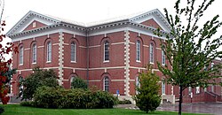
Platte County Courthouse in Platte City was built after the original courthouse was burned with the rest of Platte City during the American Civil War. Blanche Barrow was held at the adjoining jail following a Bonnie & Clyde shootout just south of Platte City.
According to the U.S. Census Bureau, the county has a total area of 427 square miles (1,110 km2), of which 420 square miles (1,100 km2) is land and 6.6 square miles (17 km2) (1.5%) is water.[5] The county's southwestern border with Kansas is formed by the Missouri River.
U.S. Decennial Census[7] 1790-1960[8] 1900-1990[9] 1990-2000[10] 2010-2015[1]
As of the census[11] of 2000, there were 73,781 people, 29,278 households, and 20,231 families residing in the county. The population density was 176 people per square mile (68/km2). There were 30,902 housing units at an average density of 74 per square mile (28/km2). The racial makeup of the county was 91.45% White, 3.49% Black or African American, 0.46% Native American, 1.48% Asian, 0.20% Pacific Islander, 1.05% from other races, and 1.87% from two or more races. Approximately 3.00% of the population were Hispanic or Latino of any race. 23.4% were of German, 12.5% Irish, 12.2% American and 11.4% English ancestry.
There were 29,278 households, out of which 34.10% had children under the age of 18 living with them, 57.00% were married couples living together, 8.80% had a female householder with no husband present, and 30.90% were non-families. 24.90% of all households were made up of individuals, and 6.00% had someone living alone who was 65 years of age or older. The average household size was 2.49 and the average family size was 3.00.
In the county, the population was spread out, with 25.80% under the age of 18, 8.30% from 18 to 24, 32.60% from 25 to 44, 24.50% from 45 to 64, and 8.80% who were 65 years of age or older. The median age was 36 years. For every 100 females there were 98.10 males. For every 100 females age 18 and over, there were 95.50 males.
The median income for a household in the county was $55,849, and the median income for a family was $65,236. Males had a median income of $44,310 versus $31,005 for females. The per capita income for the county was $26,356. About 3.30% of families and 4.80% of the population were below the poverty line, including 5.70% of those under age 18 and 5.70% of those age 65 or over.
The Republican Party controls politics at the local level in Platte County. Republicans hold all of the elected positions in the county. However, GovernorJay Nixon carried the county in his two successful elections, and in 2004, Claire McCaskill of Jackson County narrowly won a majority of the county's votes over Republican victor Matt Blunt.
Platte County is divided into four legislative districts in the Missouri House of Representatives, three held by Republicans and one held by a Democrat.
District 11 — Galen Wayne Higdon, Jr. (R-St. Joseph). Consists of the communities of Dearborn, Edgerton, Tracy, and Weston.
Missouri House of Representatives — District 11 — Platte County (2016)
Party
Candidate
Votes
%
±%
Republican
Galen Wayne Higdon, Jr.
2,690
100.00%
Missouri House of Representatives — District 11 — Platte County (2014)
Party
Candidate
Votes
%
±%
Republican
Galen Wayne Higdon, Jr.
1,298
100.00%
Missouri House of Representatives — District 11 — Platte County (2012)
Party
Candidate
Votes
%
±%
Republican
Galen Wayne Higdon, Jr.
2,454
100.00%
District 12 — Kenneth Wilson (R-Smithville). Consists of Camden Point, Platte City, and Ridgely.
Missouri House of Representatives — District 12 — Platte County (2016)
Party
Candidate
Votes
%
±%
Republican
Kenneth Wilson
3,125
62.75%
-3.10
Democratic
Sandy Van Wagner
1,696
34.06%
-0.09
Libertarian
Glenn Gustitus
159
3.19%
+3.19
Missouri House of Representatives — District 12 — Platte County (2014)
Party
Candidate
Votes
%
±%
Republican
Kenneth Wilson
1,666
65.85%
-34.15
Democratic
Sandy Van Wagner
864
34.15%
+34.15
Missouri House of Representatives — District 12 — Platte County (2012)
Party
Candidate
Votes
%
±%
Republican
Kenneth Wilson
4,025
100.00%
District 13 — Nick Marshall (R-Parkville). Consists of the communities of Farley, Ferrelview, Parkville, Waldron, Weatherby Lake, and a part of the city of Kansas City.
Missouri House of Representatives — District 13 — Platte County (2016)
Party
Candidate
Votes
%
±%
Republican
Nick Marshall
12,440
59.02%
-40.98
Democratic
Tyler McCall
8,636
40.98%
+40.98
Missouri House of Representatives — District 13 — Platte County (2014)
Party
Candidate
Votes
%
±%
Republican
Nick Marshall
7,539
100.00%
+38.04
Missouri House of Representatives — District 13 — Platte County (2012)
Party
Candidate
Votes
%
±%
Republican
Nick Marshall
11,712
61.96%
Democratic
Gerry Byrne
7,192
38.04
District 14 – Matt Sain (D-Kansas City). Consists of the communities of Houston Lake, Lake Waukomis, Northmoor, Platte Woods, Riverside, and part of the city of Kansas City.
Missouri House of Representatives — District 14 — Platte County (2018)
Party
Candidate
Votes
%
±%
Republican
Kevin Corlew
8,716
50.17%
-2.49
Democratic
Matt Sain
8,656
49.83%
+2.49
Missouri House of Representatives — District 14 — Platte County (2016)
Party
Candidate
Votes
%
±%
Republican
Kevin Corlew
10,084
52.66%
-3.55
Democratic
Martin T. Rucker II
9,067
47.34%
+3.55
Missouri House of Representatives — District 14 — Platte County (2014)
Party
Candidate
Votes
%
±%
Republican
Kevin Corlew
4,812
56.21%
+1.40
Democratic
Stephanie Isaacson
3,749
43.79
-1.40
Missouri House of Representatives — District 14 — Platte County (2012)
Party
Candidate
Votes
%
±%
Republican
Ron Schieber
9,459
54.81%
Democratic
Eric Pendell
7,799
45.19%
All of Platte County is a part of Missouri's 34th District in the Missouri Senate and is currently represented by Rob Schaaf (R-St. Joseph).
Missouri Senate — District 34 — Platte County (2014)
Party
Candidate
Votes
%
±%
Republican
Rob Schaaf
13,071
59.26%
Democratic
Martin T. Rucker
8,987
40.74%
Federal[]
U.S. Senate — Missouri — Platte County (2016)
Party
Candidate
Votes
%
±%
Republican
Roy Blunt
22,929
46.76%
+6.99
Democratic
Jason Kander
23,795
48.52%
-3.96
Libertarian
Jonathan Dine
1,413
2.88%
-4.87
Green
Johnathan McFarland
530
1.08%
+1.08
Constitution
Fred Ryman
371
0.76%
+0.76
U.S. Senate — Missouri — Platte County (2012)
Party
Candidate
Votes
%
±%
Republican
Todd Akin
17,870
39.77%
Democratic
Claire McCaskill
23,578
52.48%
Libertarian
Jonathan Dine
3,480
7.75%
All of Platte County is included in Missouri's 6th Congressional District and is currently represented by Sam Graves (R-Tarkio) in the U.S. House of Representatives.
U.S. House of Representatives – Missouri’s 6th Congressional District – Platte County (2016)
Party
Candidate
Votes
%
±%
Republican
Sam Graves
29,596
60.91%
-1.12
Democratic
David M. Blackwell
17,016
35.02%
+1.33
Libertarian
Russ Lee Monchil
1,321
2.72%
-1.56
Green
Mike Diel
653
1.34%
+1.34
U.S. House of Representatives — Missouri's 6th Congressional District — Platte County (2014)
Party
Candidate
Votes
%
±%
Republican
Sam Graves
13,780
62.03%
-0.01
Democratic
Bill Hedge
7,483
33.69%
-1.66
Libertarian
Russ Lee Monchil
951
4.28%
+1.67
U.S. House of Representatives — Missouri's 6th Congressional District — Platte County (2012)
Former U.S. SenatorHillary Clinton (D-New York) received more votes, a total of 5,434, than any candidate from either party in Platte County during the 2008 presidential primary.