Prince's Bay station
Prince's Bay | |||||||||||||||||||||||||||||||||||||||||||||||||||||||||||||
|---|---|---|---|---|---|---|---|---|---|---|---|---|---|---|---|---|---|---|---|---|---|---|---|---|---|---|---|---|---|---|---|---|---|---|---|---|---|---|---|---|---|---|---|---|---|---|---|---|---|---|---|---|---|---|---|---|---|---|---|---|---|
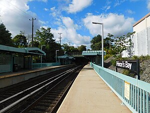 View of platforms facing southbound | |||||||||||||||||||||||||||||||||||||||||||||||||||||||||||||
| Station statistics | |||||||||||||||||||||||||||||||||||||||||||||||||||||||||||||
| Address | Seguine Avenue & Waterbury Avenue Staten Island, NY 10309 | ||||||||||||||||||||||||||||||||||||||||||||||||||||||||||||
| Borough | Staten Island | ||||||||||||||||||||||||||||||||||||||||||||||||||||||||||||
| Locale | Prince's Bay | ||||||||||||||||||||||||||||||||||||||||||||||||||||||||||||
| Coordinates | 40°31′31″N 74°12′01″W / 40.5254°N 74.2003°WCoordinates: 40°31′31″N 74°12′01″W / 40.5254°N 74.2003°W | ||||||||||||||||||||||||||||||||||||||||||||||||||||||||||||
| Division | [1] | ||||||||||||||||||||||||||||||||||||||||||||||||||||||||||||
| Services | Local Express | ||||||||||||||||||||||||||||||||||||||||||||||||||||||||||||
| Transit | |||||||||||||||||||||||||||||||||||||||||||||||||||||||||||||
| Structure | Open-cut | ||||||||||||||||||||||||||||||||||||||||||||||||||||||||||||
| Platforms | 2 side platforms | ||||||||||||||||||||||||||||||||||||||||||||||||||||||||||||
| Tracks | 2 | ||||||||||||||||||||||||||||||||||||||||||||||||||||||||||||
| Other information | |||||||||||||||||||||||||||||||||||||||||||||||||||||||||||||
| Opened | June 2, 1860[2] | ||||||||||||||||||||||||||||||||||||||||||||||||||||||||||||
| Station code | 517[3] | ||||||||||||||||||||||||||||||||||||||||||||||||||||||||||||
| Former/other names | Lemon Creek[2] | ||||||||||||||||||||||||||||||||||||||||||||||||||||||||||||
| Station succession | |||||||||||||||||||||||||||||||||||||||||||||||||||||||||||||
| Next north | Huguenot | ||||||||||||||||||||||||||||||||||||||||||||||||||||||||||||
| Next south | Pleasant Plains | ||||||||||||||||||||||||||||||||||||||||||||||||||||||||||||
| |||||||||||||||||||||||||||||||||||||||||||||||||||||||||||||
| |||||||||||||||||||||||||||||||||||||||||||||||||||||||||||||
| |||||||||||||||||||||||||||||||||||||||||||||||||||||||||||||


Prince's Bay is a Staten Island Railway station in the neighborhood of Prince's Bay, Staten Island, New York.
History[]
The station opened on June 2, 1860 as Lemon Creek, with the opening of the Staten Island Railway from Annadale to Tottenville.[2] Prior to being placed in an open-cut the station consisted of a small platform connected to a small station house, which was connected to a two-story house. The platform could be reached by going up a short staircase.[4]
Station layout[]
The station is located near Seguine Avenue and Amboy Road on the main line, and is located is in an open-cut with two side platforms, green canopies, and walls of steel and concrete. A railroad spur leading to the St. George-bound tracks also exists just outside of this parking lot. Maps do not show the station name with apostrophe while the station signs do. The latter is the historically correct (and official) name. This station was the last all-timber platform on the line before being replaced in the early 1990s.
| G | Street level | Station house, exit/entrance, buses |
| P Platform level |
Side platform | |
| Southbound | ← | |
| Northbound | | |
| Side platform | ||
Exits[]
There is an exit/entrance on the south end of each platform that allows access to Seguine Avenue. An exit/entrance on the northern end of the St. George (north) bound platform allows access to a small free commuter park & ride lot that is accessible from Herbert Street.[5][6]
References[]
- ^ "Glossary". Second Avenue Subway Supplemental Draft Environmental Impact Statement (SDEIS) (PDF). Vol. 1. Metropolitan Transportation Authority. March 4, 2003. pp. 1–2. Archived from the original (PDF) on February 26, 2021. Retrieved January 1, 2021.
- ^ a b c Irvin Leigh and Paul Matus (December 23, 2001). "SIRT The Essential History". p. 5. Retrieved March 3, 2009.
- ^ "Station Developers' Information". Metropolitan Transportation Authority. Retrieved June 13, 2017.
- ^ "Princes Bay train station". statenisland.pastperfectonline.com. 1895 to 1915. Retrieved December 23, 2017.
{{cite web}}: Check date values in:|date=(help) - ^ "Map of NYC Subway Entrances". NYC Open Data. City of New York. Retrieved July 10, 2018.
- ^
- Rosenfeld, Robbie (January 20, 2010). "Image of Prince's Bay 109502". nycsubway.org. Retrieved December 24, 2017.
- Rosenfeld, Robbie (January 20, 2010). "Image of Prince's Bay 109501". nycsubway.org. Retrieved December 24, 2017.
External links[]
![]() Media related to Prince's Bay (Staten Island Railway station) at Wikimedia Commons
Media related to Prince's Bay (Staten Island Railway station) at Wikimedia Commons
- Staten Island Railway stations
- Railway stations in the United States opened in 1860
- 1860 establishments in New York (state)
- Prince's Bay, Staten Island