Tower Hill station (Staten Island Railway)
Tower Hill | |||
|---|---|---|---|
| Former Staten Island Railway station | |||
 Sharpe Avenue | |||
| Station statistics | |||
| Borough | Staten Island | ||
| Coordinates | 40°38′19″N 74°08′14″W / 40.6387°N 74.1373°WCoordinates: 40°38′19″N 74°08′14″W / 40.6387°N 74.1373°W | ||
| Division | [1] | ||
| Line | SIR North Shore Branch | ||
| Services | none | ||
| Platforms | 1 island platform | ||
| Tracks | 2 | ||
| Other information | |||
| Opened | February 23, 1886 | ||
| Closed | March 31, 1953 | ||
| Station succession | |||
| Next north | Elm Park | ||
| Next south | Port Richmond | ||
| |||
| |||


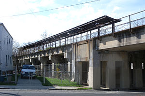
Tower Hill is a station on the abandoned North Shore Branch of the Staten Island Railway, located in between the Port Richmond and Elm Park neighborhoods. The station lies between Treadwell and Sharpe Avenues about 3.4 miles (5.5 km) from the Saint George Terminal,[2] with two tracks and an island platform. It is one of the three best-preserved stations on the line, the other two being Port Richmond and the line's western terminus at Arlington, in Mariners Harbor.
History[]
The station opened on February 23, 1886.[3][4] Formerly a surface station, it and the Port Richmond station one stop east were elevated onto the current concrete trestle in 1935 as part of an SIRT grade crossing elimination project, opening as an elevated station on February 25, 1937.[3][5][6][7][8][9] West of the station past Nicholas Avenue, the line recedes into an open-cut.[5] Tower Hill station closed on March 31, 1953, along with the South Beach Branch and the rest of the North Shore Branch.[3][9]
Station layout[]
| P Platform level |
Westbound | Trackbed |
| Island platform, not in use | ||
| Eastbound | Trackbed | |
| G | Street level | Exit/Entrance |
It is one of the few stations along the North Shore Branch still standing, although in ruins.
Like the nearby Port Richmond Station, the station has a concrete island platform with a metal canopy and street staircases at both ends of the platform. The westernmost exit is at Treadwell Avenue. The easternmost exit is just east of Sharpe Avenue on private property, leading to an empty lot on Grove Avenue.
References[]
- ^ "Glossary". Second Avenue Subway Supplemental Draft Environmental Impact Statement (SDEIS) (PDF). Vol. 1. Metropolitan Transportation Authority. March 4, 2003. pp. 1–2. Archived from the original (PDF) on February 26, 2021. Retrieved January 1, 2021.
- ^ Office of Diane J. Savino (2013). "State Senator Diane J. Savino's 2013 Staten Island Railway Rider Report" (PDF). nysenate.gov. New York State Senate. Retrieved July 31, 2015.
- ^ a b c Leigh, Irvin; Matus, Paul (January 2002). "State Island Rapid Transit: The Essential History". thethirdrail.net. The Third Rail Online. Retrieved June 27, 2015.
- ^ [1]
- ^ a b Pitanza, Marc (2015). Staten Island Rapid Transit Images of Rail. Arcadia Publishing. ISBN 978-1-4671-2338-9.
- ^ "Opens S.I. Viaduct; Longest in Nation". Brooklyn Daily Eagle. February 26, 1937. Retrieved August 25, 2015.
- ^ "Staten Island Opens Mile-Long Viaduct: Thirty-four Grade Crossings Are Eliminated" (PDF). The New York Times. February 26, 1937. Retrieved June 27, 2015.
- ^ "Open S.I. Viaduct: Longest in Nation". Brooklyn Daily Eagle. February 26, 1937. Retrieved July 19, 2015 – via Newspapers.com.
- ^ a b "NYCT NORTH SHORE ALTERNATIVES ANALYSIS: Alternatives Analysis Report" (PDF). mta.info. Metropolitan Transportation Authority. August 2012. Retrieved July 20, 2015.
- North Shore Branch stations
- Railway stations in the United States opened in 1886
- Railway stations closed in 1953
- 1886 establishments in New York (state)
- 1953 disestablishments in New York (state)