Regional District of East Kootenay
East Kootenay | |
|---|---|
| Regional District of East Kootenay | |
 | |
|
Logo | |
Major communities | |
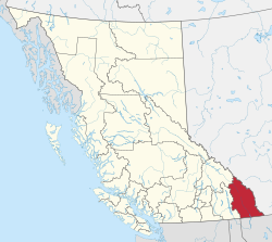 Location in British Columbia | |
| Country | Canada |
| Province | British Columbia |
| Administrative office location | Cranbrook |
| Government | |
| • Type | Regional district |
| • Body | Board of directors |
| • Chair | Rob Gay (C) |
| • Vice chair | Clara Reinhardt (Radium Hot Springs) |
| • Electoral areas |
|
| Area | |
| • Land | 27,541.84 km2 (10,633.96 sq mi) |
| Population (2016)[2] | |
| • Total | 60,439 |
| • Density | 2.2/km2 (6/sq mi) |
| Time zones | |
| Most of the district | UTC-7 (Mountain (MST)) |
| • Summer (DST) | UTC-6 (Mountain Daylight (MDT)) |
| Electoral area C (no DST) | UTC-7 (Mountain (MST)) |
| Website | www |
The Regional District of East Kootenay (RDEK) is a regional district in the Canadian province of British Columbia, Canada. At the 2016 census, the population was 60,439. Its area is 27,542.69 square kilometres (10,641.16 sq mi). The regional district offices are in Cranbrook, the largest community in the region. Other important population centres include the cities of Kimberley and Fernie, and the district municipality of Invermere and Sparwood. Despite its name, the regional district does not include all of the region known as the East Kootenay, which includes the Creston Valley and the east shore of Kootenay Lake.
Geography[]
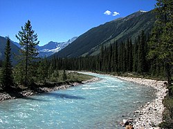
The regional district's dominant landform is the Rocky Mountain Trench, which is flanked by the Purcell Mountains and Rocky Mountains on the east and west, and includes the Columbia Valley region, the southern half of which is in the regional district (its northern half is in the Columbia-Shuswap Regional District). Another distinct area within the regional district is the Elk Valley in the southern Rockies, which is the entrance to the Crowsnest Pass and an important coal-mining region. Other than the Columbia and Kootenay Rivers, whose valleys form the bottomlands of the Rocky Mountain Trench, also included in the regional district are the northernmost parts of the basins of the Flathead, Moyie and Yahk Rivers (the Moyie and Yahk are tributaries of the Kootenay, entering it in the United States, and the Flathead is a tributary of the Clark Fork in Montana).
Municipalities[]
| Municipality | Government Type | Population |
| Cranbrook | city | 20,047 |
| Kimberley | city | 7,425 |
| Fernie | city | 5,249 |
| Sparwood | district municipality | 3,784 |
| Invermere | district municipality | 3.391 |
| Jumbo Glacier | mountain resort municipality | 0 |
| Elkford | district municipality | 2,499 |
| Radium Hot Springs | village | 776 |
| Canal Flats | village | 668 |
Health care[]
The largest hospital in the region is the East Kootenay Regional Hospital in Cranbrook.[3] There are also hospitals in Creston (Creston Valley Hospital),[4] Fernie (Elk Valley Hospital),[5] Invermere (Invermere & District Hospital),[6] and Golden (Golden & District Hospital).[7] Primary health centers are present in Sparwood and Elkford.[8][9]
First Nations[]
The First Nations people who live in the East Kootenay are from the Ktunaxa Nation.[10] There are currently four bands Columbia Lake First Nation near Windermere, Lower Kootenay First Nation near Creston, St. Mary's First Nation near Cranbrook, and Tobacco Plains First Nation near Grasmere.[10]
See also[]
References[]
- ^ "Board of Directors". Retrieved July 9, 2019.
- ^ a b "Population and dwelling counts, for Canada, provinces and territories, and census divisions, 2016 and 2011 censuses – 100% data (British Columbia)". Statistics Canada. February 8, 2017. Retrieved July 9, 2019.
- ^ "Information Page". www.interiorhealth.ca. Retrieved January 4, 2021.
- ^ "Information Page". www.interiorhealth.ca. Retrieved January 4, 2021.
- ^ "Information Page". www.interiorhealth.ca. Retrieved January 4, 2021.
- ^ "Invermere & District Hospital". www.interiorhealth.ca. Retrieved January 4, 2021.
- ^ "Golden & District Hospital". www.interiorhealth.ca. Retrieved January 4, 2021.
- ^ "Sparwood Primary Health Care". www.interiorhealth.ca. Retrieved January 4, 2021.
- ^ "Elkford Health Centre". www.interiorhealth.ca. Retrieved January 4, 2021.
- ^ a b "Our History – Lower Kootenay Band". lowerkootenay.com. Retrieved January 4, 2021.
- [1] Census Profile, 2016 Census, East Kootenay
External links[]
| Wikimedia Commons has media related to Regional District of East Kootenay. |
- Official website

 East Kootenays travel guide from Wikivoyage
Places adjacent to Regional District of East Kootenay | ||||||||||||||||
|---|---|---|---|---|---|---|---|---|---|---|---|---|---|---|---|---|
| ||||||||||||||||
Subdivisions of British Columbia | ||
|---|---|---|
| Subdivisions |  | |
| Communities |
| |
| Metro areas and agglomerations |
| |
| Regional districts |
| |
| ||
This article about a location in the Regional District of East Kootenay, Canada is a stub. You can help Wikipedia by . |
- Regional District of East Kootenay
- Regional districts of British Columbia
- British Columbia Interior geography stubs