Richibucto
Richibucto | |
|---|---|
Town | |
 | |
 Richibucto Location within New Brunswick | |
| Coordinates: 46°41′N 64°52′W / 46.68°N 64.87°WCoordinates: 46°41′N 64°52′W / 46.68°N 64.87°W | |
| Country | Canada |
| Province | New Brunswick |
| County | Kent County |
| Founded | Early 1800s |
| Government | |
| • Type | Town Council |
| • Mayor | Roger Doiron |
| Area | |
| • Total | 11.93 km2 (4.61 sq mi) |
| Population (2016)[1] | |
| • Total | 1,266 |
| • Density | 106.2/km2 (275/sq mi) |
| Time zone | UTC-4 (AST) |
| • Summer (DST) | UTC-3 (ADT) |
| Canadian Postal code | E4W |
| Area code(s) | 506 |
| Website | www |

Richibucto is a town in Kent County, New Brunswick, Canada.[2]
Geography[]
The town is situated on the Richibucto River where it discharges into the Northumberland Strait.
History[]
Richibucto had been the location of an annual Mi'kmaq summer coastal community prior to British colonisation.[3] The town takes its name from "Elsipogtog" or "L'sipuktuk" Mi'kmaq terms meaning "river of fire".[4] It is believed the term was mispronounced, or misunderstood from the Mi'kmaq language. See Elsipogtog First Nation.
Present day[]
The downtown area, situated on the mouth of the river, has commercial fishing wharves, several restaurants, and local stores. The economy is dominated by lobster and deep sea fishing.
Demographics[]
| Year | Pop. | ±% |
|---|---|---|
| 1981 | 1,722 | — |
| 1986 | 1,609 | −6.6% |
| 1991 | 1,469 | −8.7% |
| 1996 | 1,414 | −3.7% |
| 2001 | 1,341 | −5.2% |
| 2006 | 1,290 | −3.8% |
| 2011 | 1,286 | −0.3% |
| 2016 | 1,266 | −1.6% |
| [5][1] | ||
|
Religious make-up (2001)
|
Income (2006)
|
Mother tongue language (2016)[6]
|
Attractions[]
 Richibucto Head Lighthouse in 2007 | |
 | |
| Location | Richibucto, New Brunswick, Canada |
|---|---|
| Coordinates | 46°40′11″N 64°42′42″W / 46.669792°N 64.711622°W |
| Tower | |
| Constructed | 1865 (first) |
| Foundation | masonry base |
| Construction | wooden tower |
| Height | 10 m (33 ft) |
| Shape | square truncated tower with balcony and lantern[7][8][9] |
| Markings | white tower, red lantern |
| Operator | Canadian Coast Guard |
| Light | |
| First lit | 1901 (current) |
| Deactivated | 1901 (first) |
| Focal height | 18 m (59 ft) |
| Lens | fourth-order Fresnel lens |
| Light source | main power |
| Range | 14 nmi (26 km; 16 mi) |
| Characteristic | Fl W 5s |
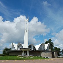
St. Louis de Gonzague Roman Catholic Church is a notable Richibucto landmark
- St. Louis de Gonzague Roman Catholic Church was completed in 1965. Designed by Belanger and Roy of Moncton, it was inspired by the designs of the Spanish architect, Félix Candela.[10]
Notable people[]
- Kate McPhelim Cleary (1863–1905), novelist
- James Hannay (1842–1910), lawyer
- Murray MacLaren (1861–1942), doctor, politician
- George McLeod (1836–1905),
- James D. Phinney (November 17, 1844 – ) lawyer, judge, politician
- Henry Powell (1855–1930), politician
- Louis Robichaud (1925–2005), former Premier of New Brunswick
- Peter Veniot (1863–1926), former Premier of New Brunswick
- Charles Wesley Weldon (1830–1896), lawyer, politician
See also[]
References[]
- ^ a b c "Census Profile, 2016 Census: Richibucto, New Brunswick". Statistics Canada. Retrieved August 14, 2019.
- ^ Richibucto Town Website
- ^ "Micmac Locations". Micmac Tribe. Access Genealogy. Retrieved 27 May 2014.
- ^ History of Richibucto Archived 2007-09-28 at the Wayback Machine
- ^ Statistics Canada: 1996, 2001, 2006 census
- ^ Statistics Canada: [1] census
- ^ List of Lights, Pub. 110: Greenland, The East Coasts of North and South America (Excluding Continental U.S.A. Except the East Coast of Florida) and the West Indies (PDF). List of Lights. United States National Geospatial-Intelligence Agency. 2015. p. {{{page}}}.
- ^ Rowlett, Russ. "Lighthouses of Canada: Northern New Brunswick". The Lighthouse Directory. University of North Carolina at Chapel Hill. Retrieved 30 March 2017.
- ^ "Richibucto Head, NB". Lighthouse Friends. Retrieved 30 March 2017.
- ^ John Leroux, Building New Brunswick: An Architectural History, Goose Lane, 2008, p. 216-219
External links[]
- Aids to Navigation Canadian Coast Guard
| Wikisource has the text of the 1905 New International Encyclopedia article "Richibucto". |
| Wikimedia Commons has media related to Richibucto. |
| Subdivisions |
|
|---|---|
| Cities |
|
| Towns | |
| |
Authority control | |||
|---|---|---|---|
| General |
| ||
| National libraries | |||
| Other | |||
| Additional |
| ||
Categories:
- Pages using infobox lighthouse with custom Wikidata item
- Communities in Kent County, New Brunswick
- Towns in New Brunswick
- Populated coastal places in Canada
- Lighthouses in New Brunswick