Roja Municipality
Roja Municipality
Rojas novads | |
|---|---|
 Flag  Coat of arms | |
 | |
| Country | |
| Formed | 2009 |
| Centre | Roja, Latvia |
| Government | |
| • Council Chair | Eva Kārkliņa (LZP) |
| Area | |
| • Total | 200.61 km2 (77.46 sq mi) |
| • Land | 196.95 km2 (76.04 sq mi) |
| • Water | 3.66 km2 (1.41 sq mi) |
| Population (2021)[2] | |
| • Total | 3,390 |
| • Density | 17/km2 (44/sq mi) |
| Website | www |
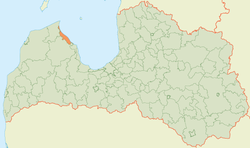
Roja Municipality (Latvian: Rojas novads) is a former municipality in Courland, Latvia. The municipality was formed in 2009 by merging Mērsrags parish and Roja parish the administrative centre being Roja. Since 2010 a separate Mērsrags municipality has been created. The population in 2020 was 3,368.[3]
On 1 July 2021, Roja Municipality ceased to exist and its territory was merged into Talsi Municipality.[4]
See also[]
- Administrative divisions of Latvia (2009)
References[]
- ^ https://data.stat.gov.lv/pxweb/lv/OSP_PUB/START__ENV__DR__DRT/DRT010/; Central Statistical Bureau of Latvia; retrieved: 25 February 2021.
- ^ https://data.stat.gov.lv/pxweb/lv/OSP_PUB/START__POP__IR__IRS/IRD060/; Central Statistical Bureau of Latvia; retrieved: 15 June 2021.
- ^ "ISG020. Population number and its change by statistical region, city, town, 21 development centres and county". Central Statistical Bureau of Latvia. 2020-01-01. Retrieved 2021-02-12.
- ^ [1] Law on Administrative Territories and Populated Areas
Coordinates: 57°30′30″N 22°48′33″E / 57.50833°N 22.80917°E

| Authority control: National libraries |
|---|
This Courland location article is a stub. You can help Wikipedia by . |
Categories:
- Roja Municipality
- Former municipalities of Latvia
- Courland geography stubs