Roslyn, New York
Roslyn, New York | |
|---|---|
Village | |
| Incorporated Village of Roslyn | |
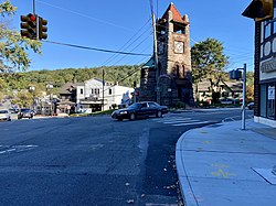 Main Street and Old Northern Boulevard in Downtown Roslyn, looking southeast. The famous Ellen Ward Clock Tower is at right. | |
| Nickname(s): "The Village" | |
 Location in Nassau County and the state of New York. | |
 Location within the state of New York | |
| Coordinates: 40°48′0″N 73°39′02″W / 40.80000°N 73.65056°WCoordinates: 40°48′0″N 73°39′02″W / 40.80000°N 73.65056°W[1] | |
| Country | |
| State | |
| County | |
| Town | North Hempstead |
| Settled | 1643[2] |
| Incorporated | 1932[2] |
| Named for | Roslin, Scotland |
| Government | |
| • Mayor | John Durkin |
| Area | |
| • Total | 0.66 sq mi (1.70 km2) |
| • Land | 0.65 sq mi (1.67 km2) |
| • Water | 0.01 sq mi (0.03 km2) |
| Elevation | 91 ft (30 m) |
| Population | |
| • Total | 2,770 |
| • Estimate (2019)[6] | 2,902 |
| • Density | 4,492.26/sq mi (1,735.48/km2) |
| Demonym(s) | Roslynian Roslynite |
| Time zone | UTC-5 (Eastern (EST)) |
| • Summer (DST) | UTC-4 (EDT) |
| ZIP code(s) | 11576 |
| Area code(s) | 516 |
| FIPS code | 36-63770 |
| GNIS feature ID | 0962929 |
| Website | https://www.roslynny.gov/ |

Roslyn (/ˈrɒzlɪn/ ROZ-lin) is a village in the Town of North Hempstead in Nassau County, on the North Shore of Long Island, in New York, United States. As of the 2010 Census, the population of the village was 2,770. It is the Greater Roslyn area's anchor community.
History[]
Roslyn was initially settled by colonists in the year 1633.[7] Originally, Roslyn was called Hempstead Harbor, but its name was changed to Roslyn on September 7, 1844 due to postal confusion regarding all the other "Hempsteads" scattered about Long Island.[8] The name "Roslyn" was selected as the new name, as its location in a valley reminded officials of Roslin, Scotland.[7][9]
Roslyn was incorporated as a village in 1932.[9] Its first Mayor was Anton E. Walbridge.[10]
The Ellen E. Ward Memorial Clock Tower in Roslyn was designed by Lamb and Rich, and was completed in 1895.[11][12] It was sold to the Village of Roslyn by the Town of North Hempstead for $1 for its centennial in 1995.[13]
Geography[]
According to the United States Census Bureau, the village has a total area of 0.6 square miles (1.6 km2), of which, 0.6 square miles (1.6 km2) of it is land and 1.56% is water.[14]
Roslyn is split between two minor drainage areas: Hempstead Harbor (part of the Hempstead Harbor Watershed) and Mill River (part of the Mill River Watershed).[15][16][17] The majority of Roslyn is within the Hempstead Harbor Watershed, meaning water in those areas drains north to Hempstead Harbor and ultimately into the Long Island Sound.[16][17] Meanwhile, the southwestern edge of the village is within the Mill River Watershed, meaning water in that area drains south to the Mill River and ultimately into Hewlett Bay and the Atlantic Ocean.[16][17] All of Roslyn is located within the larger Long Island Sound/Atlantic Ocean Watershed.[16][17][18]
According to the United States Environmental Protection Agency and the United States Geological Survey, the highest point in Roslyn is located near Piper Court, at approximately 253 feet (77 m), and the lowest point is Hempstead Harbor, which is at sea level.[16][17][19]
According to the Köppen Climate Classification, Roslyn has a four-season warm temperate climate (type Cfa) with cool, wet winters and hot, humid summers. Precipitation is uniform throughout the year, with slight spring and fall peaks. It is located in hardiness zone 7b, along with much of the inner New York area, due to the coastal location and urban heat island effect. Data is taken from nearby Mineola station.
| hideClimate data for MINEOLA, NY, 1991-2020 normals | |||||||||||||
|---|---|---|---|---|---|---|---|---|---|---|---|---|---|
| Month | Jan | Feb | Mar | Apr | May | Jun | Jul | Aug | Sep | Oct | Nov | Dec | Year |
| Average high °F (°C) | 41.6 (5.3) |
44.1 (6.7) |
51.1 (10.6) |
62.1 (16.7) |
71.9 (22.2) |
80.9 (27.2) |
86.5 (30.3) |
84.5 (29.2) |
77.5 (25.3) |
66.7 (19.3) |
55.9 (13.3) |
46.5 (8.1) |
64.1 (17.8) |
| Daily mean °F (°C) | 34.4 (1.3) |
36.2 (2.3) |
42.8 (6.0) |
52.7 (11.5) |
62.1 (16.7) |
71.2 (21.8) |
77.1 (25.1) |
75.3 (24.1) |
68.7 (20.4) |
57.9 (14.4) |
47.9 (8.8) |
39.6 (4.2) |
55.5 (13.1) |
| Average low °F (°C) | 27.2 (−2.7) |
28.2 (−2.1) |
34.5 (1.4) |
43.3 (6.3) |
52.2 (11.2) |
61.5 (16.4) |
67.7 (19.8) |
66.1 (18.9) |
59.8 (15.4) |
49.2 (9.6) |
39.8 (4.3) |
32.6 (0.3) |
46.8 (8.2) |
| Average precipitation inches (mm) | 3.65 (93) |
3.00 (76) |
4.41 (112) |
3.75 (95) |
3.13 (80) |
3.80 (97) |
4.04 (103) |
3.92 (100) |
4.08 (104) |
4.02 (102) |
3.35 (85) |
4.18 (106) |
45.33 (1,151) |
| Average snowfall inches (cm) | 2.9 (7.4) |
6.2 (16) |
3.1 (7.9) |
0.4 (1.0) |
0.0 (0.0) |
0.0 (0.0) |
0.0 (0.0) |
0.0 (0.0) |
0.0 (0.0) |
0.0 (0.0) |
0.2 (0.51) |
5.7 (14) |
18.5 (47) |
| Average precipitation days (≥ 0.01 in) | 10.6 | 9.5 | 10.5 | 10.9 | 10.5 | 9.0 | 8.7 | 8.5 | 7.9 | 8.2 | 8.8 | 10.6 | 113.7 |
| Average snowy days (≥ 0.1 in) | 1.8 | 2.3 | 1.2 | 0.2 | 0.0 | 0.0 | 0.0 | 0.0 | 0.0 | 0.0 | 0.1 | 1.4 | 7.0 |
| Source: NOAA[20][21] | |||||||||||||
Demographics[]
| Historical population | |||
|---|---|---|---|
| Census | Pop. | %± | |
| 1940 | 972 | — | |
| 1950 | 1,612 | 65.8% | |
| 1960 | 2,681 | 66.3% | |
| 1970 | 2,607 | −2.8% | |
| 1980 | 2,134 | −18.1% | |
| 1990 | 1,965 | −7.9% | |
| 2000 | 2,570 | 30.8% | |
| 2010 | 2,770 | 7.8% | |
| 2019 (est.) | 2,902 | [6] | 4.8% |
| U.S. Decennial Census[22] | |||


2010 Census[]
As of the 2010 census[23] the population was 86% White (76% Non-Hispanic White), 2.2% Black or African American, 0.2% Native American, 8.85% Asian, 2.6% from other races, and 2.2% from two or more races. Hispanic or Latino of any race were 11.2% of the population.
2000 Census[]
As of the census [5] of 2000, there were 2,570 people, 1,060 households, and 603 families residing in the village. The population density was 4,082.2 people per square mile (1,575.1/km2). There were 1,124 housing units at an average density of 1,785.4 per square mile (688.9/km2). The racial makeup of the village was 86.81% White, 2.33% African American, 0.08% Native American, 6.15% Asian, 2.02% from other races, and 2.61% from two or more races. Hispanic or Latino of any race were 6.34% of the population.
There were 1,060 households, out of which 25.8% had children under the age of 18 living with them, 47.3% were married couples living together, 7.1% had a female householder with no husband present, and 43.1% were non-families. 37.7% of all households were made up of individuals, and 9.5% had someone living alone who was 65 years of age or older. The average household size was 2.17 and the average family size was 2.89.
In the village, the population was spread out, with 18.2% under the age of 18, 3.6% from 18 to 24, 30.2% from 25 to 44, 25.3% from 45 to 64, and 22.7% who were 65 years of age or older. The median age was 44 years. For every 100 females, there were 83.8 males. For every 100 females age 18 and over, there were 78.4 males.
The median income for a household in the village was $72,404, and the median income for a family was $101,622. Males had a median income of $65,156 versus $45,221 for females. The per capita income for the village was $47,166. About 1.3% of families and 4.1% of the population were below the poverty line, including 2.9% of those under age 18 and 2.7% of those age 65 or over.
Government[]
Village government[]
As of July 2021, the Mayor of Roslyn is John Durkin, the Deputy Mayor is Marshall E. Bernstein, and the Trustees are Marta Genovese, Sarah Oral, and Craig Westergard.[24]
Representation in higher government[]
Town representation[]
Roslyn is located in the Town of North Hempstead's 4th district, which as of July 2021 is represented on the Town Board by Veronica Lurvey (D–Great Neck).[25]
Nassau County representation[]
Roslyn is located in Nassau County's 11th Legislative district, which as of July 2021 is represented in the Nassau County Legislature by Delia DiRiggi-Whitton (D–Glen Cove).[26][27]
New York State representation[]
New York State Assembly[]
Roslyn is split between the New York State Assembly's 13th Assembly district, which as of July 2021 is represented by Charles Lavine (D–Glen Cove).[26]
New York State Senate[]
Roslyn is located in the New York State Senate's 7th State Senate district, which as of July 2021 is represented in the New York State Senate by Anna Kaplan (D–North Hills).[26][28]
Federal representation[]
United States Congress[]
Roslyn is located in New York's 3rd congressional district, which as of July 2021 is represented in the United States Congress by Tom Suozzi (D–Glen Cove).[26][29]
United States Senate[]
Like the rest of New York, Roslyn is represented in the United States Senate by Charles Schumer (D) and Kirsten Gillibrand (D).[30]
Politics[]
In the 2016 U.S. presidential election, the majority of Roslyn voters voted for Hillary Clinton (D).[31]
Education[]
School district[]
The Village of Roslyn is served entirely by the Roslyn Union Free School District, which consists of five schools: Heights School, Harbor Hill School, East Hills School, Roslyn Middle School, and Roslyn High School.[26][32] In 2016, Roslyn High School was ranked 42nd in the state and 342nd in the nation.[33] The Roslyn school mascot is the Bulldog.
The Heights School serves pre-kindergarten and kindergarten for the entire district, and as first grade for half the students in the Roslyn area (students that will attend East Hills School for elementary school).
The two elementary schools each serve half of the Roslyn school district. Harbor Hill School provides education for students in grades one through five. The East Hills School serves students in grades two through five.
Roslyn Middle School has grades six through eight. Roslyn High School, built on land donated by the Mackay family, serves students in grades nine through twelve.
Library district[]
The Village of Roslyn is located entirely within the service area of Roslyn's library district, which is the Bryant Library.[26]
Infrastructure[]

Transportation[]
The William Cullen Bryant Viaduct (carrying New York State Route 25A) passes through and serves as a bypass of Roslyn.[34]
Utilities[]
Water[]
Roslyn is within the boundaries of the Roslyn Water District, which provides the entirety of Roslyn with water.[26]
Sewage[]
The Village of Roslyn operates a sanitary sewer system.[26][35] The sewage from the Village's sewer system is pumped to and is treated by the Nassau County Sewage District's treatment plants, via. the East Hills Interceptor line, which connects the village's system with Nassau County's.[36][37][38]
Prior to having the sanitary waste treated by Nassau County's facilities, the village's sewer system expelled the sanitary sewage locally into Hempstead Harbor, contributing to water pollution problems.[38]
Notable people[]
- Deborah Asnis – Infectious disease specialist; Asnis reported the first human cases of West Nile virus in the United States in 1999.[39]
- Nathan Banks – Entomologist and arachnologist.
- Michael Crichton – Author of Jurassic Park and creator of ER.[40]
- Allison Danzig – Sportswriter for The New York Times; author.
- Judy Steinberg Dean – Physician, First Lady of Vermont (1991–2003) and wife of former Gov. Howard Dean, and Roslyn High School graduate.
- Ken Hechler – Politician (D – West Virginia).[41]
- Jesse Itzler – Entrepreneur, author, and co-owner of the Atlanta Hawks.
- Edward Lampert – Chairman of Sears Holding Company.
- Bernard Madoff – former NASDAQ chairman and swindler.[42]
- Shep Messing – Olympic soccer goalkeeper and current broadcaster.
- Frank C. Moore – Artist and AIDS activist.[43]
- Lilly Pulitzer – Socialite and fashion designer.
- Samuel Rubel – Executive.[44]
- Whitney Tower – Former president of National Museum of Racing and Hall of Fame.[45]
See also[]
- Roslyn (LIRR station)
- Main Street Historic District
- Roslyn Village Historic District
References[]
- ^ "US Gazetteer files: 2010, 2000, and 1990". United States Census Bureau. 2011-02-12. Retrieved 2011-04-23.
- ^ Jump up to: a b Sloam, Myrna (2006). "Timeline of Roslyn History". Nassau County Library. Archived from the original on 2008-07-04. Retrieved 2008-07-02.
- ^ "2019 U.S. Gazetteer Files". United States Census Bureau. Retrieved July 27, 2020.
- ^ "US Board on Geographic Names". United States Geological Survey. 2007-10-25. Retrieved 2008-01-31.
- ^ Jump up to: a b "U.S. Census website". United States Census Bureau. Retrieved 2008-01-31.
- ^ Jump up to: a b "Population and Housing Unit Estimates". United States Census Bureau. May 24, 2020. Retrieved May 27, 2020.
- ^ Jump up to: a b NY, Village of Roslyn. "Village of Roslyn, NY - About Roslyn". www.historicroslyn.org. Archived from the original on January 14, 2015. Retrieved 2016-04-17.
- ^ About Roslyn Archived 2007-09-27 at the Wayback Machine
- ^ Jump up to: a b Winsche, Richard (October 1, 1999). The History of Nassau County Community Place-Names. Interlaken, New York: Empire State Books. ISBN 978-1557871541.
- ^ "Rubel Estate Overlooking Roslyn Harbor To Be Developed With 102 'Luxury' Homes". The New York Times. 1951-05-06. ISSN 0362-4331. Retrieved 2021-07-20.
- ^ "The Ellen E. Ward Clock Tower: The Symbol of Roslyn | Roslyn News". roslyn-news.com. Retrieved 2021-07-02.
- ^ "Ellen E. Ward Memorial Clock Tower | Profiles | Roslyn Landmark Society". www.roslynlandmarks.org. Retrieved 2021-07-02.
- ^ Ackerman, Ruthie (2006-10-27). "Despite Repair Hurdles, a Clock Tower Is Saved". The New York Times. ISSN 0362-4331. Retrieved 2021-07-02.
- ^ "Roslyn Village, New York Profile". data.census.gov. Retrieved 2020-09-11.
- ^ "WATER QUALITY IMPROVEMENT PLAN FOR HEMPSTEAD HARBOR NASSAU COUNTY NEW YORK" (PDF). Hempstead Harbor Protection Committee. May 1998. Retrieved 2020-06-16.
- ^ Jump up to: a b c d e "EPA – Waters GeoViewer". United States Environmental Protection Agency. Retrieved 2021-07-28.
- ^ Jump up to: a b c d e New York Rapid Watershed Assessment Profile – Northern Long Island Watershed. Syracuse, New York: United States Department of Agriculture Natural Resources Conservation Service. 2011.
- ^ "Atlantic Ocean/Long Island Sound Watershed - NYS Dept. of Environmental Conservation". www.dec.ny.gov. Retrieved 2021-07-27.
- ^ "The National Map - Advanced Viewer". United States Geological Survey. Retrieved 2021-07-30.
- ^ "NOWData - NOAA Online Weather Data". National Oceanic and Atmospheric Administration. Missing or empty
|url=(help);|access-date=requires|url=(help) - ^ "Summary of Monthly Normals 1991-2020". National Oceanic and Atmospheric Administration. Retrieved September 7, 2021.
- ^ "Census of Population and Housing". Census.gov. Retrieved June 4, 2015.
- ^ "U.S. Census website".
- ^ "Board of Trustees | Roslyn, NY". www.roslynny.gov. Retrieved 2021-07-05.
- ^ "Town of North Hempstead - Councilwoman Veronica Lurvey". northhempsteadny.gov. Retrieved 2021-07-22.
- ^ Jump up to: a b c d e f g h "Long Island Index: Interactive Map". Long Island Index Maps. Long Island Index.
- ^ "District 11 - Delia DeRiggi-Whitton | Nassau County, NY - Official Website". www.nassaucountyny.gov. Retrieved 2020-12-18.
- ^ "NY Senate District 7". NY State Senate. Retrieved 2021-07-22.
- ^ "Suozzi Declares Victory In NY 3rd Congressional District Race". Huntington, NY Patch. 2020-11-17. Retrieved 2021-07-22.
- ^ "U.S. Senate: Contacting U.S. Senators". www.senate.gov. Retrieved 2021-07-22.
- ^ Welch, Will (2017-11-08). "How Long Island Voted". Newsday. Retrieved 2021-06-23.
- ^ "Roslyn Public Schools". 2013-02-22. Archived from the original on 2013-02-22. Retrieved 2020-09-11.
- ^ "Roslyn High School in ROSLYN HEIGHTS, NY | Best High Schools | US News". www.usnews.com. Retrieved 2016-04-17.
- ^ Russell, Ellen; Russell, Sargent (2009). Roslyn. Images of America. Arcadia Publishing. p. 56. ISBN 978-0-7385-6505-7. LCCN 2008942609.
- ^ "Public Works | Roslyn, NY". www.roslynny.gov. Retrieved 2021-08-06.
- ^ "Wastewater Management Program | Nassau County, NY - Official Website". www.nassaucountyny.gov. Retrieved 2021-08-06.
- ^ "Sewerage Map – Nassau County". County of Nassau, New York. Retrieved 2021-08-05.
- ^ Jump up to: a b Times, Roy R. Silver Special to The New York (1975-02-02). "Nassau‐Roslyn Pact to End the Discharge of Sewage Into Hempstead Harbor". The New York Times. ISSN 0362-4331. Retrieved 2021-08-17.
- ^ Colker, David (2015-09-21). "Deborah Asnis dies at 59; helped detect West Nile virus in U.S." Los Angeles Times. Retrieved 2015-10-10.
- ^ Website, M. C. "For Younger Readers". MichaelCrichton.com. Retrieved 2021-07-23.
- ^ Donna Baxter. "the News-Leader". Archived from the original on May 1, 2013. Retrieved April 29, 2013.
- ^ "Wall Street legend Bernard Madoff arrested over $50 billion Ponzi scheme". The Times. London. 2008-12-12. Archived from the original on June 14, 2011. Retrieved 2010-05-22.
- ^ Local History Collection, The Bryant Library (2021-06-21). "Frank C. Moore, Class of 1971". Roslyn Local History. Retrieved 2021-07-23.
- ^ TIMES, Special to THE NEW YORK (1946-04-16). "RUBEL RESIDENCE DESTROYED IN FIRE; $1,750,000 Loss Estimated at Roslyn, Including Jewelry, Antiques and Paintings". The New York Times. ISSN 0362-4331. Retrieved 2021-07-20.
- ^ Durso, Joseph (1999-02-12). "Whitney Tower, 75, Writer And Leader in Horse Racing". The New York Times. ISSN 0362-4331. Retrieved 2021-07-23.
External links[]
| Wikimedia Commons has media related to Roslyn, New York. |
| show Places adjacent to Roslyn, New York |
|---|
| show Authority control |
|---|
- Roslyn, New York
- Town of North Hempstead, New York
- Villages in New York (state)
- Villages in Nassau County, New York
- Populated coastal places in New York (state)