Saint-Étienne-Lardeyrol
Saint-Étienne-Lardeyrol | |
|---|---|
Commune | |
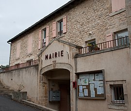 Town hall | |
show Location of Saint-Étienne-Lardeyrol | |
 Saint-Étienne-Lardeyrol | |
| Coordinates: 45°04′20″N 4°00′07″E / 45.0722°N 4.0019°ECoordinates: 45°04′20″N 4°00′07″E / 45.0722°N 4.0019°E | |
| Country | France |
| Region | Auvergne-Rhône-Alpes |
| Department | Haute-Loire |
| Arrondissement | Le Puy-en-Velay |
| Canton | Emblavez-et-Meygal |
| Government | |
| • Mayor (2020–2026) | Marc Giraud[1] |
| Area 1 | 11.8 km2 (4.6 sq mi) |
| Population (Jan. 2018)[2] | 759 |
| • Density | 64/km2 (170/sq mi) |
| Time zone | UTC+01:00 (CET) |
| • Summer (DST) | UTC+02:00 (CEST) |
| INSEE/Postal code | 43181 /43260 |
| Elevation | 669–1,033 m (2,195–3,389 ft) (avg. 815 m or 2,674 ft) |
| 1 French Land Register data, which excludes lakes, ponds, glaciers > 1 km2 (0.386 sq mi or 247 acres) and river estuaries. | |


Saint-Étienne-Lardeyrol (Auvergnat: Sant Estève) is a commune in the Haute-Loire department in south-central France.
Population[]
|
|
See also[]
References[]
- ^ "Répertoire national des élus: les maires". data.gouv.fr, Plateforme ouverte des données publiques françaises (in French). 2 December 2020.
- ^ "Populations légales 2018". INSEE. 28 December 2020.
| Wikimedia Commons has media related to Saint-Étienne-Lardeyrol. |
This Haute-Loire geographical article is a stub. You can help Wikipedia by . |
Categories:
- Communes of Haute-Loire
- Haute-Loire geography stubs