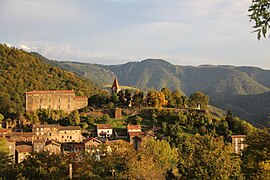
Saint-Privat-d'Allier
Saint-Privat-d'Allier | |
|---|---|
Commune | |
 | |
show Location of Saint-Privat-d'Allier | |
 Saint-Privat-d'Allier | |
| Coordinates: 44°59′27″N 3°40′47″E / 44.9908°N 3.6797°ECoordinates: 44°59′27″N 3°40′47″E / 44.9908°N 3.6797°E | |
| Country | France |
| Region | Auvergne-Rhône-Alpes |
| Department | Haute-Loire |
| Arrondissement | Le Puy-en-Velay |
| Canton | Saint-Paulien |
| Government | |
| • Mayor (2020–2026) | Guy Eyraud[1] |
| Area 1 | 37.67 km2 (14.54 sq mi) |
| Population (Jan. 2018)[2] | 398 |
| • Density | 11/km2 (27/sq mi) |
| Time zone | UTC+01:00 (CET) |
| • Summer (DST) | UTC+02:00 (CEST) |
| INSEE/Postal code | 43221 /43580 |
| Elevation | 547–1,221 m (1,795–4,006 ft) (avg. 875 m or 2,871 ft) |
| 1 French Land Register data, which excludes lakes, ponds, glaciers > 1 km2 (0.386 sq mi or 247 acres) and river estuaries. | |


Saint-Privat-d'Allier (French pronunciation: [sɛ̃ pʁiva dalje], literally Saint-Privat of Allier; Occitan: Sent Privat d'Alèir) is a commune in the Haute-Loire department in south-central France. On 1 January 2017, the former commune of Saint-Didier-d'Allier was merged into Saint-Privat-d'Allier.[3]
Population[]
|
|
See also[]
References[]
- ^ "Répertoire national des élus: les maires". data.gouv.fr, Plateforme ouverte des données publiques françaises (in French). 2 December 2020.
- ^ "Populations légales 2018". INSEE. 28 December 2020.
- ^ Arrêté préfectoral 27 September 2016 (in French)
| Wikimedia Commons has media related to Saint-Privat-d'Allier. |
This Haute-Loire geographical article is a stub. You can help Wikipedia by . |
Categories:
- Communes of Haute-Loire
- Haute-Loire geography stubs