Saint-Paul-de-Tartas
Saint-Paul-de-Tartas | |
|---|---|
Commune | |
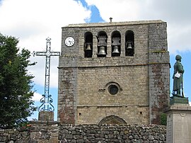 Bell tower | |
 Coat of arms | |
show Location of Saint-Paul-de-Tartas | |
 Saint-Paul-de-Tartas | |
| Coordinates: 44°48′16″N 3°54′27″E / 44.8044°N 3.9075°ECoordinates: 44°48′16″N 3°54′27″E / 44.8044°N 3.9075°E | |
| Country | France |
| Region | Auvergne-Rhône-Alpes |
| Department | Haute-Loire |
| Arrondissement | Le Puy-en-Velay |
| Canton | Velay volcanique |
| Intercommunality | Pays de Cayres et de Pradelles |
| Government | |
| • Mayor (2014–2020) | Michel Adam |
| Area 1 | 27.47 km2 (10.61 sq mi) |
| Population (Jan. 2018)[1] | 187 |
| • Density | 6.8/km2 (18/sq mi) |
| Time zone | UTC+01:00 (CET) |
| • Summer (DST) | UTC+02:00 (CEST) |
| INSEE/Postal code | 43215 /43420 |
| Elevation | 933–1,342 m (3,061–4,403 ft) (avg. 1,200 m or 3,900 ft) |
| 1 French Land Register data, which excludes lakes, ponds, glaciers > 1 km2 (0.386 sq mi or 247 acres) and river estuaries. | |


Saint-Paul-de-Tartas is a commune in the Haute-Loire department in south-central France.
Population[]
| Year | Pop. | ±% |
|---|---|---|
| 1793 | 700 | — |
| 1806 | 870 | +24.3% |
| 1821 | 799 | −8.2% |
| 1831 | 840 | +5.1% |
| 1841 | 1,014 | +20.7% |
| 1851 | 990 | −2.4% |
| 1861 | 1,004 | +1.4% |
| 1872 | 1,038 | +3.4% |
| 1881 | 1,134 | +9.2% |
| 1891 | 1,199 | +5.7% |
| 1901 | 1,225 | +2.2% |
| 1911 | 1,053 | −14.0% |
| 1921 | 1,033 | −1.9% |
| 1931 | 973 | −5.8% |
| 1946 | 761 | −21.8% |
| 1954 | 675 | −11.3% |
| 1962 | 585 | −13.3% |
| 1968 | 514 | −12.1% |
| 1975 | 415 | −19.3% |
| 1982 | 341 | −17.8% |
| 1990 | 270 | −20.8% |
| 1999 | 244 | −9.6% |
| 2008 | 188 | −23.0% |
| 2017 | 194 | +3.2% |
See also[]
References[]
- ^ "Populations légales 2018". INSEE. 28 December 2020.
| Wikimedia Commons has media related to Saint-Paul-de-Tartas. |
This Haute-Loire geographical article is a stub. You can help Wikipedia by . |
Categories:
- Communes of Haute-Loire
- Haute-Loire geography stubs