Saint-Isidore Parish, New Brunswick
Saint-Isidore
St. Isidore | |
|---|---|
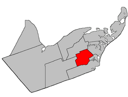 Location within Gloucester County, New Brunswick | |
| Coordinates: 47°34′N 65°08′W / 47.57°N 65.14°W | |
| Country | |
| Province | |
| County | Gloucester |
| Erected | 1881 |
| Area | |
| • Land | 173.25 km2 (66.89 sq mi) |
| Population (2016)[1] | |
| • Total | 1,361 |
| • Density | 7.9/km2 (20/sq mi) |
| • Change 2011-2016 | |
| • Dwellings | 658 |
| Time zone | UTC-4 (AST) |
| • Summer (DST) | UTC-3 (ADT) |

Saint-Isidore is a civil parish in Gloucester County, New Brunswick, Canada.[2]
For governance purposes it is divided between the Regional Municipality of Tracadie, the village of Saint-Isidore, and the local service district of the parish of Saint-Isidore[a] (which further includes the special service area of Bois-Blanc - Hacheyville - Duguayville), all of which are members of the Acadian Peninsula Regional Service Commission (APRSC).[3]
Origin of name[]
The parish's name may have come from Saint Isidore, Patron Saint of farmers.[4]
History[]
Saint-Isidore was erected in 1881 from Inkerman and Saumarez Parishes.[5]
In 1947 part of Saint-Isidore was included in the newly erected Allardville Parish.[6]
Boundaries[]
Saint-Isidore Parish is bounded:[2][7][8]
- on the north by the southern line of Range 6 of Paquetville South Settlement, which is on the south side of the Val-Doucet Road, from just west of the Pokemouche River northeast of Spruce Brook Road, to a point between Route 355 and Sugary Brook;
- on the east by a line starting at the point between Route 355 and Sugary Brook, then running southeasterly to strike the southern side of the Saint-Raymond Road on the southeastern corner of a grant that crosses both the W. Gautreau Road and Gaspereau Creek, then westerly along the southern line of the grant to Gaspereau Creek, then downstream to the southern line of a tier of grants along the W. Gautreau Road;
- on the south by a line running the southern line of a tier of grants along W. Gautreau Road and its prolongation to the sharp bend of Boishébert Road on the eastern edge of Saint-Isidore, then southeasterly to the rear line of Range 6 of the Saint Isidore Settlement, which is on the south side of Route 160, then southwesterly to the eastern line of Range 7, then southeasterly along the eastern line of Ranges 7, 8 (along part of Alderwood Road), and 9 to the Little Tracadie River, then up the Little Tracadie until it strikes the southern line of Range 9 again, then southwesterly along Range 9 and its prolongation to the southwestern corner of timber block 7, east of the Big Tracadie River;
- on the west by the western line of timber block 7 and the western line of Ranges 5 and 6 of the Saint Isidore Settlement, which are on either side of Route 160, to the northwestern corner of Range 5, then northeasterly to the prolongation of the north line of Range 1 in the Saint Isidore Settlement, which runs along the north side of Mallais Road, then northwesterly along the western line of Range 1 to its northwestern corner, then northeasterly along the northern line of Range 1 to just east of the Pokemouche River northeast of Spruce Brook Road, then northwesterly along grant lines to the southern line of Range 6 of Paquetville South.
Communities[]
Communities at least partly within the parish.[7][8][9] bold indicates an incorporated municipality
- Bois-Blanc
- Bois-Gagnon
- Duguayville
- Hacheyville
- Haut-Saint-Isidore
- Saint-Isidore
- Boishébert
- Spruce Brook
- Tilley Road
- Tracadie
- Upper Tilley Road
Bodies of water[]
Bodies of water[b] at least partly within the parish.[7][8][9]
- Little Tracadie River
- Pokemouche River
- Lac Saint-Coeur
Demographics[]
Parish population total does not include village of Saint-Isidore and portion within Regional Municipality of Tracadie
Population[]
|
Language[]Mother tongue (2016)[1]
|
Notes[]
- ^ The LSD of the parish of Saint-Isidore extends into Paquetville Parish, Saint-Isidore Parish does not.
- ^ Not including brooks, ponds or coves.
References[]
- ^ a b c d "Census Profile, 2016 Census: Saint-Isidore, Parish [Census subdivision], New Brunswick". Statistics Canada. Retrieved September 10, 2019.
- ^ a b "Chapter T-3 Territorial Division Act". Government of New Brunswick. Retrieved 13 November 2020.
- ^ "Communities in each of the 12 Regional Service Commissions (RSC) / Les communautés dans chacune des 12 Commissions de services régionaux (CSR)" (PDF), Government of New Brunswick, July 2017, retrieved 2 February 2021
- ^ Ganong, William F. (1896). A Monograph of the Place-Nomenclature of the Province of New Brunswick. Royal Society of Canada. p. 268. Retrieved 17 March 2021.
- ^ "44 Vic. c. 34 An Act to erect part of the Parishes of Saumarez and Inkerman, in the County of Gloucester, into a separate Parish.". Acts of the General Assembly of Her Majesty's Province of New Brunswick. Passed in the Month of March 1881. Fredericton: Government of New Brunswick. 1881. pp. 70–72. Available as a free ebook from Google Books.
- ^ "10 Geo. VI. c. 90 An Act to amend the Act respecting the division of the Province into Counties, Towns and Parishes, in so far as it relates to the County of Gloucester". Acts of the Legislative Assembly of New Brunswick Passed During the Session of 1946. Fredericton: Government of New Brunswick. 1946. pp. 301–309.
- ^ a b c "No. 029". Provincial Archives of New Brunswick. Department of Natural Resources and Energy Development. Retrieved 8 June 2021. Remainder of parish on maps 30, 42, and 43 at same site.
- ^ a b c "074" (PDF). Transportation and Infrastructure. Government of New Brunswick. Retrieved 8 June 2021. Remainder of parish on mapbooks 075, 093–095, and 114 at same site.
- ^ a b "Search the Canadian Geographical Names Database (CGNDB)". Government of Canada. Retrieved 24 July 2021.
- ^ Statistics Canada: 1996, 2001, 2006 census
- ^ 2011 Statistics Canada Census Profile: Saint-Isidore Parish, New Brunswick
Places adjacent to Saint-Isidore Parish, New Brunswick | ||||||||||||||||
|---|---|---|---|---|---|---|---|---|---|---|---|---|---|---|---|---|
| ||||||||||||||||
Subdivisions of New Brunswick | |
|---|---|
| Subdivisions |
|
| Cities | |
| Counties | |
| |
Coordinates: 47°34′12″N 65°08′24″W / 47.57000°N 65.14000°W
- Local service districts of Gloucester County, New Brunswick
- Parishes of Gloucester County, New Brunswick