Saint-Jorioz
Saint-Jorioz | |
|---|---|
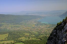 The town seen from the Col de la Cochette | |
 Coat of arms | |
show Location of Saint-Jorioz | |
 Saint-Jorioz | |
| Coordinates: 45°49′59″N 6°10′01″E / 45.8331°N 6.1669°ECoordinates: 45°49′59″N 6°10′01″E / 45.8331°N 6.1669°E | |
| Country | France |
| Region | Auvergne-Rhône-Alpes |
| Department | Haute-Savoie |
| Arrondissement | Annecy |
| Canton | Annecy-4 |
| Intercommunality | CA Grand Annecy |
| Government | |
| • Mayor (2020–2026) | Michel Beal[1] |
| Area 1 | 21.12 km2 (8.15 sq mi) |
| Population (Jan. 2018)[2] | 5,864 |
| • Density | 280/km2 (720/sq mi) |
| Demonym(s) | Saint-Joriens / Saint-Joriennes |
| Time zone | UTC+01:00 (CET) |
| • Summer (DST) | UTC+02:00 (CEST) |
| INSEE/Postal code | 74242 /74410 |
| Elevation | 443–1,657 m (1,453–5,436 ft) |
| Website | Saint-jorioz.fr |
| 1 French Land Register data, which excludes lakes, ponds, glaciers > 1 km2 (0.386 sq mi or 247 acres) and river estuaries. | |


Saint-Jorioz, located on the western banks of lake Annecy, is a commune in the Haute-Savoie department in the Auvergne-Rhône-Alpes region in south-eastern France.
World heritage site[]
It is home to one or more prehistoric pile-dwelling (or stilt house) settlements that are part of the Prehistoric Pile dwellings around the Alps UNESCO World Heritage Site.[3]
See also[]
References[]
- ^ "Répertoire national des élus: les maires". data.gouv.fr, Plateforme ouverte des données publiques françaises (in French). 2 December 2020.
- ^ "Populations légales 2018". INSEE. 28 December 2020.
- ^ UNESCO World Heritage Site - Prehistoric Pile dwellings around the Alps
| Wikimedia Commons has media related to Saint-Jorioz. |
| show Authority control |
|---|
This Haute-Savoie geographical article is a stub. You can help Wikipedia by . |
Categories:
- Communes of Haute-Savoie
- Haute-Savoie geography stubs