Saint-Louis Parish, New Brunswick
Saint-Louis
St. Louis | |
|---|---|
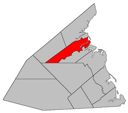 Location within Kent County, New Brunswick. | |
| Coordinates: 46°43′30″N 65°04′30″W / 46.725°N 65.075°W | |
| Country | |
| Province | |
| County | Kent |
| Erected | 1855 |
| Area | |
| • Land | 258.74 km2 (99.90 sq mi) |
| Population (2016)[1] | |
| • Total | 1,802 |
| • Density | 7.0/km2 (18/sq mi) |
| • Change 2011-2016 | |
| • Dwellings | 785 |
| Time zone | UTC-4 (AST) |
| • Summer (DST) | UTC-3 (ADT) |

Saint-Louis (originally Palmerston) is a civil parish in Kent County, New Brunswick, Canada.[2]
For governance purposes it is divided between the village of Saint-Louis de Kent and the local service districts of Saint-Ignace and the parish of Saint-Louis (which further contains the special service area of Canisto Road), all of which are members of the Kent Regional Service Commission (KRSC).[3]
Origin of name[]
The parish may take its name from the Roman Catholic ecclesiastical parish of Saint-Louis-des-Français.
History[]
Saint-Louis was erected as Palmerston Parish in 1855 from Carleton Parish.[4]
In 1857 the boundary with Carleton was altered to run along grant lines.[5]
In 1866 the parish was renamed Saint-Louis.[6]
In 1909 part of Saint-Louis was included in the new parish of Saint-Charles.[7]
Boundaries[]
Saint-Louis Parish is bounded:[2][8][9][10]
- on the west and north by a line beginning on the shore of Kouchibouguac Bay at the prolongation of the southern line of a grant about 1.5 kilometres south of the mouth of Ruisseau des Major in Kouchibouguac National Park, then running southwesterly along the grant line and its prolongation past Ruisseau des Major to the southernmost corner of the second grant, then northerly to the southern line of a grant straddling the Kouchibouguac River, then along the southern lines of five river grants until it strikes the prolongation of the starting grant line, then westerly along the prolongation to Route 134, then northwesterly along Route 134 to the southern line of Kouchibouguac River grants, then southwesterly along the northern line of two grants on either side of Route 11 and a third grant, to the northwestern corner of the third grant, then south seventy-five degrees and thirty minutes west[a] to the northern line of Weldford Parish, at a point about 3.25 kilometres west of Route 126;
- on the east by Kouchibouguac Bay and Saint-Louis Bay;
- on the southeast by a line beginning on the shore of Kouchibouguac Bay at the prolongation of the rear line of grants on the Saint-Charles River, then southwesterly along the line to near Route 134, then generally westerly along the rear line of grants along the Kouchibouguacis River until the prolongation of the Canadian National Railway line where it crosses the northern line of Weldford Parish, which runs due west from the northernmost corner of the Richibucto 15 Indian reserve;
- on the south by the northern line of Weldford Parish;
- including the islands in front in Saint-Louis Bay and Kouchibouguac Bay.
Communities[]
Communities at least partly within the parish;[8][9][10] bold indicates an incorporated municipality; italics indicate a name no longer in official use
|
|
Bodies of water[]
Bodies of water[b] at least partly in the parish:[8][9][10]
- Rivière aux Masquis
- Kouchibouguacis River
- Lac à Jos-Wilfrid
- Baie de Saint-Louis
- Saint-Louis Narrows
Conservation areas[]
Parks, historic sites, and related entities in the parish.[8][9][10]
Demographics[]
Population[]Parish population does not include the village of Saint-Louis-de-Kent Population trend[12][13][1]
|
Language[]Mother tongue (2016)[1]
|
See also[]
Notes[]
- ^ By the magnet of 1857,[5] when declination in the area was between 21º and 22º west of north.[11]
- ^ Not including brooks, ponds or coves.
References[]
- ^ Jump up to: a b c d "Census Profile, 2016 Census Saint-Louis, Parish [Census subdivision], New Brunswick". Statistics Canada. Retrieved September 14, 2019.
- ^ Jump up to: a b "Chapter T-3 Territorial Division Act". Government of New Brunswick. Retrieved 13 November 2020.
- ^ "Communities in each of the 12 Regional Service Commissions (RSC) / Les communautés dans chacune des 12 Commissions de services régionaux (CSR)" (PDF), Government of New Brunswick, July 2017, retrieved 2 February 2021
- ^ "18 Vic. c. 49 An Act to divide the Parish of Carleton, in the County of Kent, into two Parishes.". Acts of the General Assembly of Her Majesty's Province of New Brunswick, Passed in the Month of November, 1854, and in the Months of February, March, and April, 1855. Fredericton: Government of New Brunswick. 1855. p. 178. Available as a free ebook from Google Books.
- ^ Jump up to: a b "20 Vic. c. 10 An Act to amend an Act to divide the Parish of Carleton, in the County of Kent, into two Parishes.". Acts of the General Assembly of Her Majesty's Province of New Brunswick, Passed in July 1856, and March and July 1857. Fredericton: Government of New Brunswick. 1857. p. 16. Retrieved 27 March 2021.
- ^ "29 Vic. c. 10 An Act to change the name of the Parish of Palmerston in the County of Kent.". Acts of the General Assembly of Her Majesty's Province of New Brunswick, Passed in the Months of March, April, and July, 1866. Fredericton: Government of New Brunswick. 1866. p. 23. Retrieved 27 March 2021.
- ^ "8 Edward 7 c. 21 An Act to amend the Act respecting the division of the Province into Counties, Towns and Parishes, so far as relates to the County of Kent.". Acts of the Legislative Assembly of New Brunswick Passed in the Month of May 1908. Fredericton: Government of New Brunswick. 1908. pp. 49–52.
- ^ Jump up to: a b c d "No. 79". Provincial Archives of New Brunswick. Department of Natural Resources and Energy Development. Retrieved 11 June 2021. Remainder of parish on maps 80, 88, and 89 at same site.
- ^ Jump up to: a b c d "222" (PDF). Transportation and Infrastructure. Government of New Brunswick. Retrieved 11 June 2021. Remainder of parish on mapbooks 235–237 and 251–253 at same site.
- ^ Jump up to: a b c d "Search the Canadian Geographical Names Database (CGNDB)". Government of Canada. Retrieved 11 June 2021.
- ^ "Historical Magnetic Declination". National Oceanic and Atmospheric Administration. Retrieved 1 March 2021.
- ^ Statistics Canada: 1996, 2001, 2006 census
- ^ 2011 Statistics Canada Census Profile: Saint-Louis Parish, New Brunswick
| show Places adjacent to Saint-Louis Parish, New Brunswick |
|---|
| hide | |
|---|---|
| Subdivisions |
|
| Cities | |
| Counties | |
| |
Coordinates: 46°43′30″N 65°04′30″W / 46.72500°N 65.07500°W
- Parishes of Kent County, New Brunswick
- Local service districts of Kent County, New Brunswick